How Urban Street Networks and Building Density Influence Flood Severity
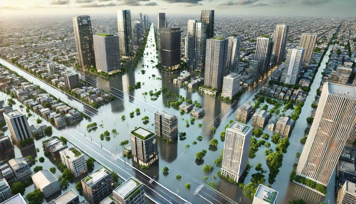
Urban flooding has become a growing concern worldwide, fuelled by a perfect storm of climate change and rapid urbanisation. From coastal cities to inland towns, the intensification of extreme weather events is a reality that’s shaping the future of urban planning.
Yet, while much focus has been placed on climate patterns, a new study from the University of California, Irvine (UC Irvine) has unveiled another crucial factor: urban form. The research points to building density and street networks as key determinants of flood severity, offering a fresh perspective for civil engineers, urban planners, and policymakers.
How Urban Layouts Shape Flood Risks
Recent findings published in Nature Communications spotlight the significance of urban form, which refers to the spatial configuration of buildings and streets in a city. The research team, led by UC Irvine’s Department of Civil and Environmental Engineering, developed an analytical model that can evaluate flood hazards at a neighbourhood level anywhere in the world. This model is built on principles derived from statistical mechanics—typically applied in physics to understand complex systems like disordered porous solids and glasses.
Co-author Mohammad Javad Abdolhosseini Qomi, associate professor at UC Irvine, emphasised the interdisciplinary approach that underpins this breakthrough. “By leveraging statistical mechanics, we’ve created a model capable of predicting flood hazards on a granular scale,” he explained. “Our method allows us to compare how different cities experience flood risks based on their urban layout. It’s a game-changer for understanding the links between urban form, flood losses, and extreme weather patterns.”
The Growing Threat of Urban Flooding
Flooding is no longer a rare event confined to monsoon-prone regions or river basins. With rapid urbanisation and the proliferation of impermeable surfaces, cities are becoming increasingly vulnerable to flash floods, especially in areas where infrastructure hasn’t kept pace with development. Lead author Sarah Balaian, a Ph.D. candidate at UC Irvine, noted that while urban flooding is a global concern, many cities lack the detailed modelling required to assess risks accurately.
“The harsh reality is that urbanisation is amplifying the impacts of climate change in ways that many cities are ill-equipped to handle,” Balaian said. “Our research addresses this gap by introducing a model that doesn’t rely solely on detailed environmental data, which many cities simply don’t have. Instead, we focus on the built environment and how its form influences flood behaviour.”
This simplified yet effective approach holds immense promise, especially for cities in low- and middle-income countries where access to comprehensive environmental data is limited. The model uses variables like building density, street orientation, and city layout to predict potential flood zones, offering a much-needed tool for regions that are often left out of the climate resilience conversation.
A Physics-Driven Approach to Flood Simulation
The UC Irvine team didn’t just stop at theoretical analysis—they validated their model through thousands of flood simulations across various city layouts. Co-author Brett Sanders, a professor of civil and environmental engineering and urban planning at UC Irvine, shared insights into the rigorous testing process. “Our simulations are grounded in the physical laws of motion,” Sanders said. “We developed a dataset covering flood depth and velocity for different urban forms observed globally. From there, we applied data analysis techniques to derive a straightforward formula that’s applicable worldwide.”
Sanders added that this formula is not only practical for planners and engineers but can also be integrated into educational curricula. “It’s vital that the next generation of civil engineers is equipped to assess how urban development decisions impact flood risks. We’re ensuring this knowledge is accessible, teachable, and adaptable.”
Implications for Urban Planning and Policy
For policymakers and urban planners, this research represents a significant leap forward in addressing flood hazards, especially in the context of rapid urban growth. Traditional flood risk assessments often rely on extensive environmental data, which is costly and time-consuming to collect. The new model, however, offers a cost-effective alternative by focusing on the urban form—a factor that is more readily observable and manageable.
This shift in perspective could have far-reaching implications. For instance, cities could begin prioritising designs that mitigate flood risks, such as incorporating more green spaces, improving drainage systems, and adopting permeable materials for roads and pavements. Additionally, the model’s scalability means it can be tailored to diverse urban settings, whether it’s a dense megacity or a sprawling suburban area.
Future-Proofing Urban Communities
The study’s release couldn’t be more timely. With climate change driving an increase in both the frequency and intensity of storms, cities need resilient infrastructure that can withstand future challenges. Urban planners now have a powerful tool that not only predicts where floods are likely to occur but also offers insights into how urban design can reduce these risks.
However, while the research is a major step forward, it also raises new questions. How will this model integrate with existing flood management practices? What role will it play in guiding new urban developments, especially in emerging economies? These are critical considerations as cities worldwide brace for an unpredictable future.
Funding and Institutional Support
The project was backed by UC Irvine’s Henry Samueli School of Engineering, with additional support from the National Science Foundation and the U.S. Department of Education.
The university, recognised as one of the top public institutions in the United States, continues to push the boundaries of interdisciplinary research, delivering innovative solutions to pressing global challenges.
Driving Change Through Data and Design
This research embodies the intersection of science, data, and urban design—offering a practical solution to one of the most pressing challenges of our time. As cities grow and the climate shifts, the ability to anticipate and mitigate flood risks will be crucial for safeguarding communities.
The UC Irvine model, with its emphasis on urban form, provides a new lens through which to view the built environment, potentially steering future urban developments toward greater sustainability and resilience.