A Universal Rulebook for Flood-Resilient Urban Transport
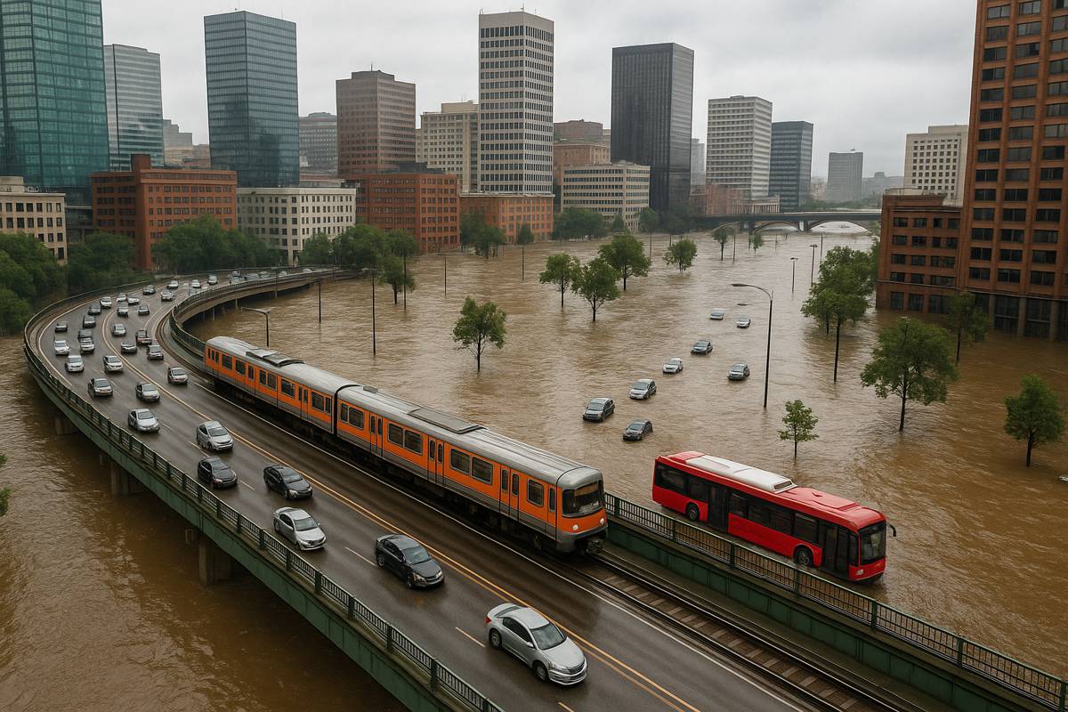
As climate change accelerates, the threat of extreme weather events grows ever more pressing. For urban planners and policymakers, floods aren’t just an inconvenience anymore — they’re an inevitable test of how well a city can hold its own. And it turns out, traffic has a few survival instincts of its own.
“In spite of increasing flood risks, more and more people are moving into flood-prone areas,” said Jianxi Gao, associate professor of computer science at Rensselaer Polytechnic Institute. “This makes it even more urgent to understand how resilient our infrastructure is — and how people adapt when disaster strikes.”
Gao is part of an international research team investigating how urban transport networks respond under the strain of severe floods. Their work, published in Nature Sustainability, shines a spotlight on a surprisingly predictable pattern of human behaviour during such disruptions. By studying traffic in Nanjing, Hamburg, and Los Angeles, the researchers uncovered a universal rule governing how people switch between public transit and private vehicles when roads go underwater.
The Science Behind the Switchover
Titled “Adaptive capacity for multimodal transport network resilience to extreme weather,” the study introduces a sophisticated traffic simulation model that mirrors real-world conditions. Using agent-based multimodal models and compound failure analytics, the team examined how millions of individual trips respond to flood-induced network failures.
In essence, the model doesn’t just track cars or buses separately. It follows people. And when push comes to shove — or, rather, when the river rises — people find a way to get to where they need to go.
What they found was consistent across very different cities: when parts of the transport network fail, people don’t simply abandon their journeys. They reroute. They swap cars for buses or trains, or vice versa, depending on what’s still working. Crucially, these switches follow a mathematical logic based on three main factors:
- Network density
- Mode competition versus complementarity
- Changes in travel demand during disruption
For example, if buses and trains support each other rather than compete, the entire network tends to bounce back faster. But when the loss of one puts pressure on the other, the system can grind to a halt.
Nanjing, Hamburg, and Los Angeles
Despite their geographical and infrastructural differences, Nanjing, Hamburg, and Los Angeles all showed similar adaptive behaviours. The simulations used real-world data, including OpenStreetMap road networks, NAVINFO and Amap mobility data, and flood hazard maps reflecting 100-year storm events.
In Nanjing, flooding disrupted subway lines. Rather than giving up, passengers migrated to the bus network, maintaining high trip completion rates. Similarly, Hamburg’s well-connected system saw commuters rerouting via trams and suburban trains, balancing the load. In Los Angeles, a city more reliant on cars, the model still revealed adaptive shifts towards what limited transit options were available.
What this indicates is that the pattern isn’t bound by geography or even infrastructure type. Instead, it follows a universal logic in human mobility resilience.
Strategies for Staying Afloat
Knowing how people will respond during floods gives cities a head start in planning for the inevitable. The study identifies several key interventions that can be deployed before, during, and after flood events:
- Emergency Public Transit Lines: Quickly activated bus or shuttle routes can pick up the slack when trains or subways are flooded.
- Dynamic Traffic Signal Control: Adjusting signal timings can reduce congestion in newly overburdened areas.
- Travel Subsidies: Offering free or discounted transit during floods encourages modal shift.
- Public Information Campaigns: Helping citizens understand alternative routes and transport modes in advance increases adaptive capacity.
These aren’t just theoretical suggestions. They’re actionable strategies rooted in behavioural modelling, and cities that act on them stand to recover more quickly from flooding events.
“This work is a step toward building smarter, more resilient infrastructure — before the next disaster hits,” Gao explained.
More Than Just Models: A Public Resource
Beyond the modelling insights, the team has made their simulations for Nanjing, Hamburg, and Los Angeles publicly available on GitHub, offering a resource for cities worldwide to study or adapt to their own needs.
The research builds on earlier efforts, such as:
- As Climate Changes, Small Increases in Rainfall May Cause Widespread Road Outages (May 9, 2019)
- Gauging the Resilience of Complex Networks (Jan. 4, 2022)
- Prediction of Human Movement During Disasters To Allow For More Effective Emergency Response (Aug. 10, 2022)
These prior studies helped lay the groundwork for the current breakthrough, pushing the boundaries of how predictive models can serve as decision-making tools in urban planning.
“Professor Gao’s work exemplifies RPI’s commitment to tackling global challenges through interdisciplinary innovation,” said Chuck Stewart, administrative dean of RPI’s School of Science. “This research not only advances our understanding of urban resilience but also provides actionable solutions for cities facing climate-driven threats.”
Looking Ahead with Confidence
There’s no sugar-coating it: floods are getting worse, not better. But what this research offers is hope — not the hand-wringing kind, but the actionable, nuts-and-bolts kind. With science pointing the way, cities don’t need to be caught off guard.
By embracing flexible, multimodal transport systems and preparing for mode-shift dynamics in advance, urban planners can ensure that when the waters rise, the wheels keep turning. And that’s not just resilience. That’s foresight in action.