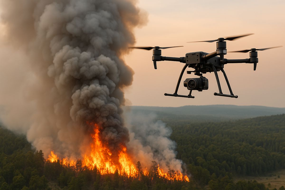
Intelligent Aerial Robotics to Transform Wildfire Smoke Analysis
Wildfires have become a persistent concern for communities worldwide, with smoke posing significant risks to health, infrastructure and the environment. As prescribed burns remain essential for land management, the need for accurate tools to monitor and predict smoke dispersion has never been more pressing.
Researchers at the University of Minnesota Twin Cities have stepped into this gap by developing advanced aerial robots equipped with artificial intelligence to detect, track and analyse wildfire smoke plumes in real time.
Their work has been published in Science of the Total Environment, highlighting its importance to the scientific community and to the wider debate on air quality management. The research aims to enhance the accuracy of computer models that forecast pollution levels, supporting more informed decisions for emergency services, policymakers and environmental agencies.
Why Better Smoke Data Matters
Prescribed burns are a necessary part of ecological stewardship, but they are not without risk. A 2024 Associated Press report noted that 43 wildfires resulted from 50,000 prescribed burns between 2012 and 2021. With rising temperatures and increasingly volatile weather conditions, understanding how smoke travels is essential for maintaining public safety.
Previous modelling tools have struggled to collect sufficiently detailed data on smoke behaviour. The unpredictable nature of fire, combined with the challenges of gathering real-world plume information, has left gaps in existing predictive models. Traditional drones and ground-based instruments often lack the flexibility or precision required for high-resolution sampling.
How AI-Guided Aerial Robots Change The Game
At the heart of this breakthrough is a swarm of AI-driven aerial robots capable of detecting smoke, navigating into plumes and capturing multidimensional data. Unlike conventional drones, these robots identify and enter regions of interest autonomously, allowing them to map smoke structure from multiple angles.
According to senior author Jiarong Hong, professor in the University of Minnesota’s Department of Mechanical Engineering: “A key step is understanding the composition of smoke particles and how they disperse. Smaller particles can travel farther and stay suspended longer, impacting regions far from the original fire.”
Using synchronised robotic movements, the team generated detailed 3D reconstructions of smoke plumes and analysed their flow patterns. This capability marks a significant advancement in smoke research, providing levels of detail previously only available through costly satellite systems.
First author Nikil Nrishnakumar from the Minnesota Robotics Institute explained the benefit: “This approach allows for high-resolution data collection across large areas, at a lower cost than satellite-based tools. It provides critical data for improving simulations and informing hazard response.”
Expanding The Technology Beyond Wildfires
Although designed with wildfire research in mind, the aerial robotic platform has potential applications far beyond fire events. The system could be adapted for:
- Sandstorm monitoring in arid regions
- Tracking volcanic ash during eruptions
- Industrial pollution assessment
- Urban air quality modelling
These wider uses underscore the versatility of the technology and reflect the growing demand for fast, granular environmental data.
Hong highlighted the importance of speed in hazard identification: “Early identification is key. The sooner you can see the fire, the faster you can respond.”
Building On Previous Breakthroughs
This project builds on earlier developments by the University of Minnesota team, who previously created an autonomous drone system capable of detecting and tracking wildfire smoke in real time using onboard vision and environmental sensors. Their new work pushes further by enabling efficient plume tracking and precise particle characterisation through Digital Inline Holography combined with coordinated multi-drone manoeuvres.
The researchers are also working on the integration of fixed-wing VTOL drones. These aircraft can take off vertically without a runway yet travel for more than an hour, offering substantial improvements for long-range monitoring missions over remote terrain.
The combination of holographic imaging, swarm robotics and extended-range UAVs is expected to reshape the way scientists understand smoke behaviour. It may also support firefighting agencies seeking faster and more accurate tools to guide response teams.
The Team Behind The Innovation
In addition to Hong and Nrishnakumar, the project team includes Shashank Sharma and Srijan Kumar Pal from the Minnesota Robotics Institute. The work received funding from the National Science Foundation Major Research Instrumentation programme, with practical support from the St. Anthony Falls Laboratory.
Their collaborative effort demonstrates how interdisciplinary research can produce meaningful advances in hazard assessment and environmental protection.
A Glimpse Into The Future Of Hazard Monitoring
As climate change intensifies the frequency and scale of wildfires, technologies like AI-guided drone swarms will become increasingly valuable. Data-driven insights can help agencies fine-tune prescribed burns, predict smoke impacts on communities and protect vulnerable infrastructure.
Researchers are aiming to transition this technology into deployable field tools capable of supporting early fire detection and real-time hazard assessment. With improvements in battery life, sensor precision and autonomous navigation, the next generation of monitoring systems promises unprecedented transparency into airborne threats.
For more technical details, readers can access the full paper, 3D characterization of smoke plume dispersion using multi-view drone swarm, available via ScienceDirect.
Safeguarding Communities
The University of Minnesota’s research marks a significant step towards smarter, more resilient environmental monitoring. As aerial robotic systems evolve, they are expected to play a central role in guiding emergency responses, shaping environmental policy and informing the public about air quality risks.
With continued investment and interdisciplinary collaboration, AI-powered drones could become essential tools for safeguarding communities in a rapidly changing world.