Drones Fuel AI-Powered Traffic Insight in Helsinki
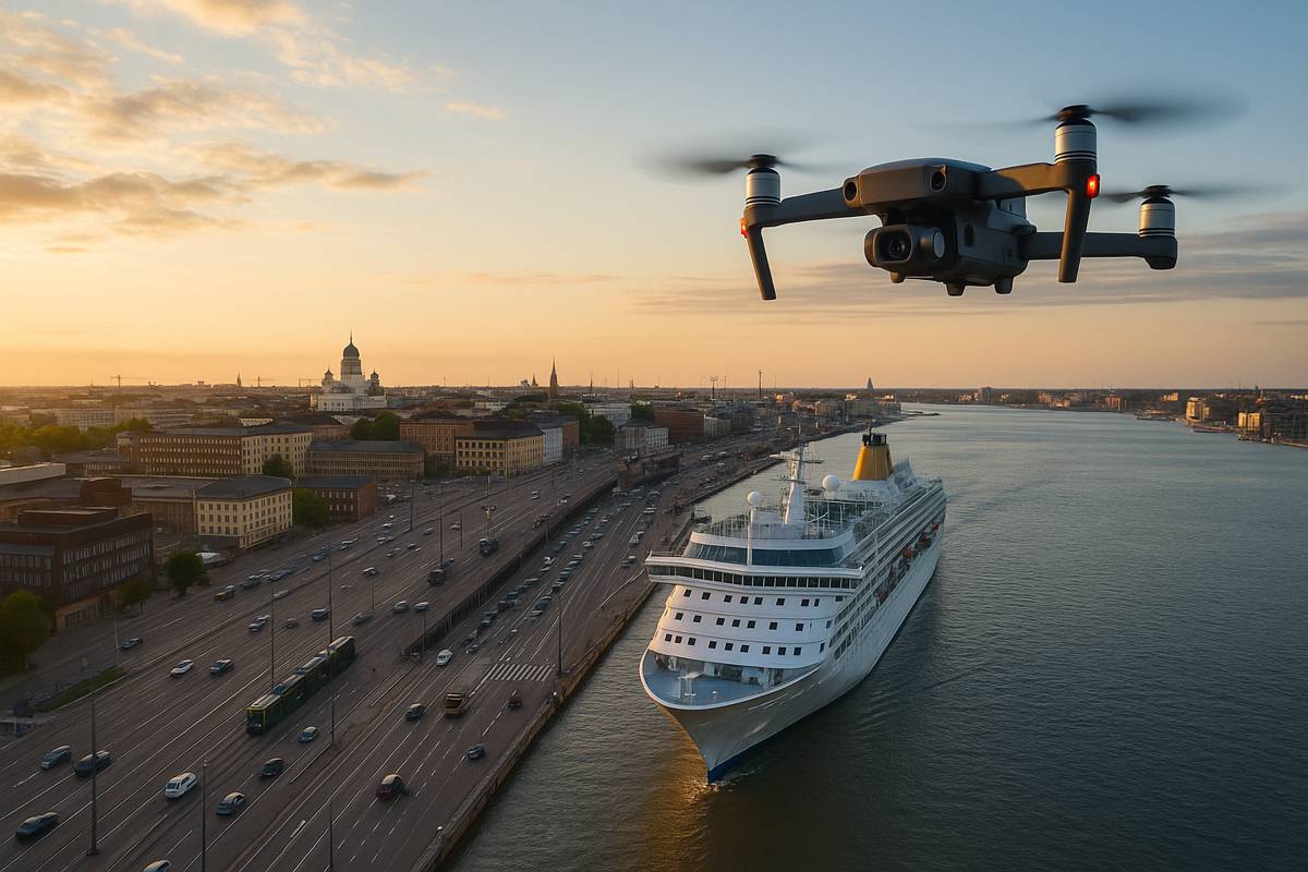
In a bold move that blends aerial surveillance with urban planning, Helsinki’s innovation arm is capturing traffic flows via drones in the city’s West Harbour.
Between 17 and 19 September 2025, six drones hovered over the area, recording movement during peak periods spurred by cruise ship arrivals and departures. The rationale? To grasp how congestion forms, how people choose routes, and how transport modes intersect, so Helsinki can refine its traffic strategies with AI-driven insight.
This marks the third and final data-gathering phase under the EU-funded ACUMEN project, a programme designed to inject smarter, greener mobility into European cities. Over the past two years, prior drone flights in 2023 and 2024 have already sketched much of the traffic contour; now, Helsinki aims to complete the picture during the harbour’s busiest window.
From Aerial Frames to Traffic Simulations
The drone campaign’s primary purpose is to harvest anonymised data around route choice and mode interactions. That means not just tracking cars, but buses, trams, trucks, bicycles, electric scooters, and pedestrian flows, essentially the full tapestry of urban mobility in the zone.
Once gathered, the footage is fed into Helsinki’s traffic simulation model. The city can then stress-test new traffic management methods in silico, anticipating bottlenecks before they arise, or mitigating them proactively. Over time, the goal is to prevent congestion rather than simply respond to it.
Senior Project Manager Eero Jalo from Forum Virium Helsinki explains: “The key challenges in the area are related to occasional congestion and ensuring sustainable mobility – such as walking, cycling and public transport. The data obtained from the flights helps us develop new AI-based tools that can manage traffic more intelligently.”
Jalo also concedes real-world caveats: some flights might be scrubbed if thunderstorms emerge or radio interference interferes. Still, the attempt signals a major step in data-driven mobility management.
ACUMEN and Smart Transport Futures
Helsinki’s drone flights are a pilot within a bigger scheme. ACUMEN is a multi-partner, multiyear initiative under Horizon Europe, with a mission to promote the green transition, responsible mobility, and citizen engagement.
In simple terms, ACUMEN aims to guide how people choose routes or modes of transport, nudging them toward more sustainable patterns. It uses AI, digital twins, and modular traffic management tools to make door-to-door trips smoother, safer, more efficient.
Helsinki, led by Forum Virium, is one of the key pilots. In this role, the city links mobility data, local transport stakeholders, and simulation platforms so the insights can migrate into policy.
Moreover, ACUMEN isn’t purely technical, it also engages policy makers. The project is constructing a regulatory and governance framework to ensure that new tools are decision-ready for urban administrators.
Lessons from the Field and Technical Considerations
Helsinki’s run is not unique. Drone traffic monitoring has been tested across cities under ACUMEN, notably in Athens, where sustained drone flights yielded trajectory data and mode-movement patterns.
From the research:
- Drone battery life and continuous recording present constraints, so multiple batteries or in-field recharging are necessary.
- Contingency days buffer against unexpected weather or regulatory setbacks.
- The bird’s-eye view adds value by enabling analysis of complex interactions, for instance, how pedestrians traverse from ferry terminals to tram platforms, or how trucks feed into local road networks.
In Helsinki’s case, earlier flights allowed the extraction of origin-destination flows via “virtual gates” on sidewalks, tram stops, and parking entrances. That in turn helped map interplay between ferry traffic, pedestrian walkways, and local vehicle access.
Crucially, the data is anonymised: no licence plates, no faces. The processing pipeline homes in on object types and trajectories, not personal identifiers.
Challenges and Public Reception
Deploying drones for traffic oversight is not without friction. Weather risks, radio interference, and airspace regulations, all could force flight cancellations or data gaps. Jalo has acknowledged as much.
Then there’s the human dimension. A recent survey of Helsinki residents explored perceptions of urban air mobility (UAM) and drone operations. Interestingly, more than half said they had “little information” about drone use; nearly a quarter reported “no information at all.”
Still, acceptance is nuanced. Drones in emergency contexts enjoy strong support (64% “very acceptable”). Environmental monitoring also ranks favourably. The primary worries? Data misuse, privacy intrusion, and criminal misuse. Noise is less of a concern.
To win public trust, Helsinki and its partners will need transparency, robust safeguards, and inclusive communication. After all, deploying drone fleets above urban districts is as much social licence as it is technological feat.
Implications for Investors, Policymakers and Construction Professionals
For investors eyeing smart city tech, Helsinki’s drone campaign offers proof of concept. The path from aerial observation to predictive simulation could yield new revenue streams in urban planning, mobility platforms, and AI tools.
Policymakers will want to watch: once reliable, AI-aided traffic management systems can reduce congestion, emissions, and transport costs, key levers for climate, economic, and social goals. The regulatory architecture being shaped via ACUMEN could serve as a blueprint for other cities.
Construction, too, has a stake. Infrastructure projects, road redesigns, transit link expansions, pedestrian improvements, can lean on simulation data to prioritise interventions. Whether adding cycle lanes or tweaking intersection geometry, the drone-derived flows can serve as real-world validation of design assumptions.
Looking ahead, future iterations might layer in real-time feedback loops, linking sensors on the ground with AI fleets in the air to dynamically adjust signal timing or reroute traffic. What’s emerging in Helsinki could be the seed of that adaptive urban system.
A Skyward Strategy for Smarter Cities
Helsinki’s drone flights represent more than a pilot, they embody a shift in urban governance. Rather than waiting for congestion to bite, cities may soon forecast and counter it intelligently. Drawing on anonymised, multimodal data, AI, simulations and citizen engagement, Helsinki is positioning itself at the frontier of smart mobility in action.
If successful, the model won’t just benefit cruise-liner timeframes in West Harbour, it could be replicated across dense corridors worldwide. When the data is rich, and the public trust secured, the skies above our cities may become as essential to traffic control as the roads below them.