VolvoCE to roll out new map feature for Haul Assist at ConExpo
VolvoCE (Volvo Construction Equipment) is rolling out a new Map feature on the Haul Assist application at CONEXPO that will allow operators to monitor hauler traffic around a jobsite and proactively adjust their driving according to traffic conditions. This update improves productivity and safety thanks to better communication and monitoring between machines.
“Haul Assist Map helps fleets work together as a more efficient unit,” said Robert Palermo, product manager, articulated haulers, Volvo CE. “Haul Assist, which launched in North America in 2019, allows operators and fleet managers to monitor the performance of their articulated hauler fleet to optimize haul cycles. It comes standard on Volvo A35G, A40G, A45G, A45G FS and A60H haulers and is an option for the A25G and A30G.
“It’s important that we continue working alongside customers to determine new features, like Map, that will help them operate more productively, efficiently and safely.”
Seeing around corners
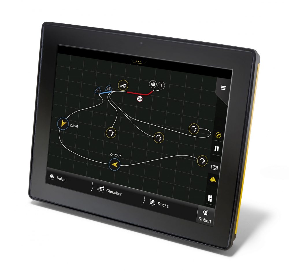
Operated via Volvo Co-Pilot — an in-cab interface with a 10-inch touch screen — Haul Assist Map uses GPS to identify the position of all haulers fitted with the technology. Being able to monitor traffic flow helps operators anticipate the optimum arrival time at load or dump areas, avoiding congestion and waiting and improving overall site efficiency. On sites with restricted visibility, it has the added benefit of allowing operators to see where other haulers are, helping reduce potentially dangerous situations.
Staying in touch
The application uses the hauler’s built-in GPS function for positioning and combines it with a digital connection via Volvo Co-Pilot to communicate with other machines. The system can also record how fast the hauler is travelling and emit an alert to remind operators to maintain a safe working speed.

Haul Assist Map on Co-Pilot
The Map function can plot out haul routes to help operators navigate their way around the site and highlight when the hauler is approaching a single-lane section that is already occupied. The map can also highlight reference points or notable areas of the site.
Volvo is also working on a future enhancement that will allow non-Volvo machines to use Haul Assist, including mapping, as long as the machines have GPS and SIM card connectivity.
Complements On-Board Weighing
Not only can load and dump zones be visualized on the map, but they can also trigger certain sub-functions such as On-Board Weighing information. On-Board Weighing, previously launched as a Haul Assist feature, shows operators real-time data on their loads, helping them eliminate under-loading and over-loading. The addition of Map enhances On-Board Weighing even further by adding the ability to include GPS coordinate data in its reports and measure material moved between various coordinates on a jobsite.
Get more details about how to use Haul Assist Map by watching this training video series: