Mapping is becoming increasingly important across global construction, infrastructure and industrial technology, influencing how projects are visualised, coordinated, delivered and managed over time.
DJI’s disclosure that it moved 10,073 kg of cargo between Everest Base Camp and Camp 1 during the spring 2026 climbing season is being reported as a mountaineering...
Exodigo’s decision to widen its product portfolio into four integrated solution categories reads less like a routine product update and more like a statement of int...
Managing extensive landscapes has traditionally required a compromise between scale and detail. Satellite imagery can cover large territories, while ground surveys reveal...
The race to build smarter machines has exposed a persistent weakness in modern perception systems. Autonomous vehicles, industrial robots, digital mapping platforms and i...
Geo Week’s decision to relocate its 2027 event from Denver to Salt Lake City marks more than a change of scenery. It signals a deliberate alignment with one of North Amer...
Urban congestion, inefficient transport networks and rising demands on infrastructure are placing extraordinary pressure on road authorities around the world. Cities are...
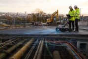
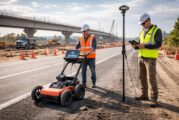
Modern infrastructure projects increasingly depend on accurate data, not only about what lies above ground but also about the hidden networks buried beneath the surface....
The global geospatial sector is entering a decisive phase. From digital twins and infrastructure resilience to AI driven analytics and satellite intelligence, location da...
The quiet digitisation of maritime chart production rarely makes headlines, yet it underpins everything from naval readiness and port construction to offshore energy and...
The push towards safer, more automated mobility has exposed a long-standing weakness in digital mapping. High-definition maps have traditionally delivered accuracy, but o...
Location has always mattered. What has changed is the precision, accessibility and analytical power now available to interpret it. As climate pressures intensify, conflic...
A breakthrough in global geospatial research has emerged from the Technical University of Munich, where a team led by Prof. Xiaoxiang Zhu has created the GlobalBuildingAt...
Looq AI has strengthened its position in the rapidly evolving world of ground-based reality capture, announcing seven new partnerships across North America, Europe, India...
Accurate land cover mapping has become a linchpin for biodiversity protection, climate adaptation, precision agriculture, and sustainable land-use planning. Yet, despite...
Access to basic sanitation remains one of the most pressing public health and social challenges in the world. Now, ground-breaking research from Australia has shed light...
Microsoft recently released a report identifying professions potentially at risk from AI automation, listing geographers among them. Professor Trisalyn Nelson, Jack and L...
In the race to make the digital world more inclusive, Maine is carving out a blueprint that could serve as a model for rural regions across the United States. For years,...
Across Asia, rivers have long served as lifelines—nourishing lands, feeding communities, and shaping ancient cultures. But for decades, thousands of dams, many now obsole...
Modern cities are a maze of high-rises, tight alleyways, and oddly shaped rooftops—a visual playground for drones and satellites, but a headache for traditional remote se...
In a move that’s set to shake up the landscape of geospatial technology, Esri has announced a deeper integration with Microsoft, leveraging the Azure OpenAI Service...
In construction, it all starts at ground level—literally. A perfectly poured slab is the first step in building anything from a humble bungalow to a glittering skyscraper...
As climate change tightens its grip and extreme weather events become the new norm, how we communicate flood risks has never been more critical. Traditional static flood...
In a bold stride toward shaping the future of urban mobility, SYSTRA Limited has selected TomTom as its go-to provider for digital maps, real-time traffic data, and locat...
In the high-stakes world of energy exploration, where every foot drilled can make or break the economics of a well, Halliburton has stepped up with a game-changing innova...
GEO Business 2025 is gearing up to take over ExCeL London from 4–5 June with a dynamic showcase of geospatial innovation, and the first wave of speakers has already set t...
Geo Connect Asia 2025 celebrates a successful show in Singapore having brought together geospatial visionaries, tech innovators, and infrastructure leaders from across th...
In a bold move poised to reshape the landscape of infrastructure analytics, Bentley Systems has teamed up with Google to turbocharge asset inspections using artificial in...
In a bold move to strengthen California’s disaster readiness, Esri has teamed up with the University of California San Diego’s ALERTCalifornia programme to em...
Navigating city streets can be a frustrating experience when unexpected road closures disrupt journeys, turning straightforward commutes into time-consuming nightmares. F...
Topcon Corporation and FARO Technologies have joined forces in a strategic agreement poised to transform the laser scanning industry. This collaboration is set to push th...
In a bold move set to transform photogrammetry and high-precision positioning, Topcon Positioning Systems and Pix4D have announced a strategic partnership. This collabora...
Topcon Positioning Systems has unveiled its latest innovation, the HiPer XR GNSS receiver, poised to set new benchmarks in surveying, mapping, and construction applicatio...
As urbanisation accelerates, cities are becoming home to an increasing majority of the global population. Currently, 56% of the global population, about 4.4 billion peopl...
In an era where location intelligence is pivotal to decision-making, the partnership between TomTom and Esri has set the stage for transformative advances in geospatial t...
Spatial data science, the art and science of interpreting geographic information, is rapidly reshaping industries. From urban planning to climate research, its ability to...
In a bold move to modernise the construction landscape, Komatsu has merged Artificial Intelligence (AI) with its cutting-edge Smart Construction Edge platform, setting a...
Blyncsy’s open API approach transforms how DOTs manage road infrastructure, offering flexibility and adaptability like never before. By publishing this highway data openl...
When it comes to making maps that aren’t just functional but also a pleasure to behold, Esri knows a thing or two—or maybe three. With the release of the third edit...
In the ever-evolving world of logistics, staying ahead of the curve is crucial for the smooth running of commercial fleets. That’s why it’s no surprise that TomTom and IV...
The seemingly solid world around us isn’t as unyielding as we might think. Beneath the surface of what we perceive as everyday matter, a dynamic universe unfolds within t...
This website uses cookies to improve your experience while you navigate through the website. Out of these, the cookies that are categorized as necessary are stored on your browser as they are essential for the working of basic functionalities of the website. We also use third-party cookies that help us analyze and understand how you use this website. These cookies will be stored in your browser only with your consent. You also have the option to opt-out of these cookies. But opting out of some of these cookies may affect your browsing experience.
Necessary cookies are absolutely essential for the website to function properly. These cookies ensure basic functionalities and security features of the website, anonymously.
Cookie
Duration
Description
cookielawinfo-checkbox-analytics
11 months
This cookie is set by GDPR Cookie Consent plugin. The cookie is used to store the user consent for the cookies in the category "Analytics".
cookielawinfo-checkbox-functional
11 months
The cookie is set by GDPR cookie consent to record the user consent for the cookies in the category "Functional".
cookielawinfo-checkbox-necessary
11 months
This cookie is set by GDPR Cookie Consent plugin. The cookies is used to store the user consent for the cookies in the category "Necessary".
cookielawinfo-checkbox-others
11 months
This cookie is set by GDPR Cookie Consent plugin. The cookie is used to store the user consent for the cookies in the category "Other.
cookielawinfo-checkbox-performance
11 months
This cookie is set by GDPR Cookie Consent plugin. The cookie is used to store the user consent for the cookies in the category "Performance".
viewed_cookie_policy
11 months
The cookie is set by the GDPR Cookie Consent plugin and is used to store whether or not user has consented to the use of cookies. It does not store any personal data.
Functional cookies help to perform certain functionalities like sharing the content of the website on social media platforms, collect feedbacks, and other third-party features.
Performance cookies are used to understand and analyze the key performance indexes of the website which helps in delivering a better user experience for the visitors.
Analytical cookies are used to understand how visitors interact with the website. These cookies help provide information on metrics the number of visitors, bounce rate, traffic source, etc.
Advertisement cookies are used to provide visitors with relevant ads and marketing campaigns. These cookies track visitors across websites and collect information to provide customized ads.