Mapping is becoming increasingly important across global construction, infrastructure and industrial technology, influencing how projects are visualised, coordinated, delivered and managed over time.
In a bold move that cements its position as a powerhouse in the geospatial industry, SAM, a leading provider of spatial data collection and analysis, has announced the ac...
Geospatial technology is no longer just the domain of cartographers and data scientists—it’s now a transformative force reshaping industries, influencing policy, an...
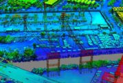
Drones have rapidly evolved from niche technology into essential tools within the construction industry. Their ability to provide aerial perspectives and gather critical...
In an era where data security is paramount, especially within government operations, Esri’s latest achievement is a significant milestone. The global leader in location i...
On November 20, 2024, the world will come together to celebrate the 25th anniversary of GIS Day, a global event that highlights the power of Geographic Information System...
In an era where urban management and planning are becoming increasingly crucial, a ground-breaking project has emerged to illuminate the urban landscape of East Asia. Res...
In a significant leap forward, Esri has announced a deepened collaboration with Microsoft, seamlessly integrating its powerful spatial analytics technology with Microsoft...
TomTom’s maps and traffic data will power location-based services across Microsoft’s solutions, reaching hundreds of millions of people and organizations daily, and the c...
The Sanborn Map Company Inc., a leader in the geospatial industry, today announced the acquisition of the assets of VeriDaaS, a cutting-edge technology company specializi...
MATT3R®, an exciting new pioneer in Artificial Intelligence (AI) technology, has begun taking pre-orders for its K3Y™ device, which enables owners of Tesla vehicle...
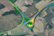
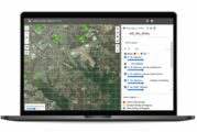
Using the new state-of-the-art mapping tool will make it easier for National Highways to keep track of its Soft Estate ecosystems bordering the country’s 4,300 miles of m...
Delta.g, the deep tech startup creating quantum enabled gravity gradiometry solutions to deliver the ‘Google Maps for the underground’ has appointed Tony Lowe...
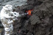
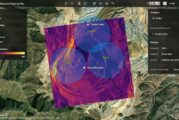
Millions of people live near active volcanoes that are constantly monitored for signs of an impending eruption. When one occurs, scientists and governments rely on data t...
The team at Sanborn Geophysics ULC has been building electro-magnetic, radiometric, and magnetic airborne geophysical survey equipment for more than thirty years. The lat...
Leica Geosystems, part of Hexagon, introduces the Leica TerrainMapper-3 airborne LiDAR sensor, featuring new scan pattern configurability to support the widest variety of...
The Sanborn Map Company has unveiled an enhanced version of its Sanborn Image Analyst™, a web-based imagery data review application accessible through the Sanborn...
In the latest AgriTech innovation a team from MIT used machine learning to analyse satellite and roadside images of areas where small farms predominate and agricultural d...
Maxar Intelligence, a provider of secure, precise, geospatial intelligence, today announced that it received a contract to provide the National Geospatial-Intelligence Ag...
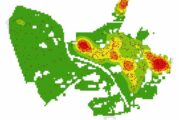
In a pioneering study published in Geo-spatial Information Science, a research group led by Yuyu Zhou from The University of Hong Kong developed an integrated framework t...
By learning about mapping skills and geography, students, teachers, and others can gain a better understanding of how the world’s most crucial issues, challenges, and opp...
Felt, the world’s first collaborative mapping tool, today launched Felt 2.0 with powerful data transformation tools that enhance its intuitive and professional platform....
In 2013, researchers carried a Microsoft Kinect camera through houses in Japan’s Fukushima Prefecture. The device’s infrared light traced the contours of the buildings, m...
As severe urban overcrowding is trending worldwide many underground development projects are being carried out in metropolitan centres worldwide. South Korea has experien...
Precisely, the global leader in data integrity, today announced its membership to the Overture Maps Foundation. Founded by Amazon Web Services (AWS), Meta, Microsoft, and...
Researchers at The University of Texas at El Paso have constructed a fully autonomous boat that can carry out bathymetric surveys — surveys of the depth and terrain of bo...
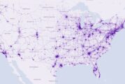
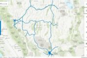
Most navigation apps can show you the fastest possible route to your destination and some can even suggest an eco-friendly route calculated to produce the least amount of...
The CHCNav CGI+ 610 is a cutting-edge GNSS receiver designed to revolutionize the world of precise positioning. With advanced features, exceptional accuracy, and robust c...
Aurigo Software, the leading provider of capital planning and construction management software for infrastructure and private owners, is partnering with the University of...
GeoPlace has provided expert resource to support the creation of the National Underground Asset Register (NUAR) which is being launched by the Geospatial Commission, part...
Most current courses for software application development focus on technology and architecture rather than the tenets of interface design. Steve Jobs was quoted as saying...
Fugro has been awarded a 6-year contract with the Louisiana Department of Transportation and Development (DOTD) for pavement distress mapping services. The contract is pa...
The purpose of mapping has been to help people navigate around places in the physical world, something that has held true for centuries. But driving has evolved and, most...
In 1990, the government of Malta formed the Malta Information Technology Agency (MITA) with a mission to manage the implementation of public IT programs; since then, the...
In an increasingly digital and automated world, geospatial data plays a critical role in understanding the physical environment and powering the next generation of locati...
Hexagon’s Safety, Infrastructure & Geospatial division announced Ness Czech, a leading Czech system integrator and supplier of IT solutions and part of Ness Digital E...
The Nevada Department of Transportation (NDOT) oversees 5,400 miles of highway and over 1,000 bridges, and is responsible for the planning, construction, operation, and m...
Exodigo, the breakthrough non-invasive subsurface imaging platform, announced a partnership today with Esri, the world leader in Geographic Information System (GIS) softw...
Climate change is compounding risks of food insecurity, displacement, and natural disasters across broad regions of the African continent, with vulnerable populations fac...
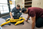
MFE Inspection Solutions announced today its appointment as a reseller of Emesent, a world leader in drone autonomy. This partnership will give MFE customers access to th...
BlackSky Technology and Esri have developed an integration that gives Esri’s global customer base access to BlackSky’s dynamic tasking services through ArcGIS Online. The...
This website uses cookies to improve your experience while you navigate through the website. Out of these, the cookies that are categorized as necessary are stored on your browser as they are essential for the working of basic functionalities of the website. We also use third-party cookies that help us analyze and understand how you use this website. These cookies will be stored in your browser only with your consent. You also have the option to opt-out of these cookies. But opting out of some of these cookies may affect your browsing experience.
Necessary cookies are absolutely essential for the website to function properly. These cookies ensure basic functionalities and security features of the website, anonymously.
Cookie
Duration
Description
cookielawinfo-checkbox-analytics
11 months
This cookie is set by GDPR Cookie Consent plugin. The cookie is used to store the user consent for the cookies in the category "Analytics".
cookielawinfo-checkbox-functional
11 months
The cookie is set by GDPR cookie consent to record the user consent for the cookies in the category "Functional".
cookielawinfo-checkbox-necessary
11 months
This cookie is set by GDPR Cookie Consent plugin. The cookies is used to store the user consent for the cookies in the category "Necessary".
cookielawinfo-checkbox-others
11 months
This cookie is set by GDPR Cookie Consent plugin. The cookie is used to store the user consent for the cookies in the category "Other.
cookielawinfo-checkbox-performance
11 months
This cookie is set by GDPR Cookie Consent plugin. The cookie is used to store the user consent for the cookies in the category "Performance".
viewed_cookie_policy
11 months
The cookie is set by the GDPR Cookie Consent plugin and is used to store whether or not user has consented to the use of cookies. It does not store any personal data.
Functional cookies help to perform certain functionalities like sharing the content of the website on social media platforms, collect feedbacks, and other third-party features.
Performance cookies are used to understand and analyze the key performance indexes of the website which helps in delivering a better user experience for the visitors.
Analytical cookies are used to understand how visitors interact with the website. These cookies help provide information on metrics the number of visitors, bounce rate, traffic source, etc.
Advertisement cookies are used to provide visitors with relevant ads and marketing campaigns. These cookies track visitors across websites and collect information to provide customized ads.