Felt 2.0 hailed as the most powerful tool for Professional Map Making
Felt, the world’s first collaborative mapping tool, today launched Felt 2.0 with powerful data transformation tools that enhance its intuitive and professional platform.
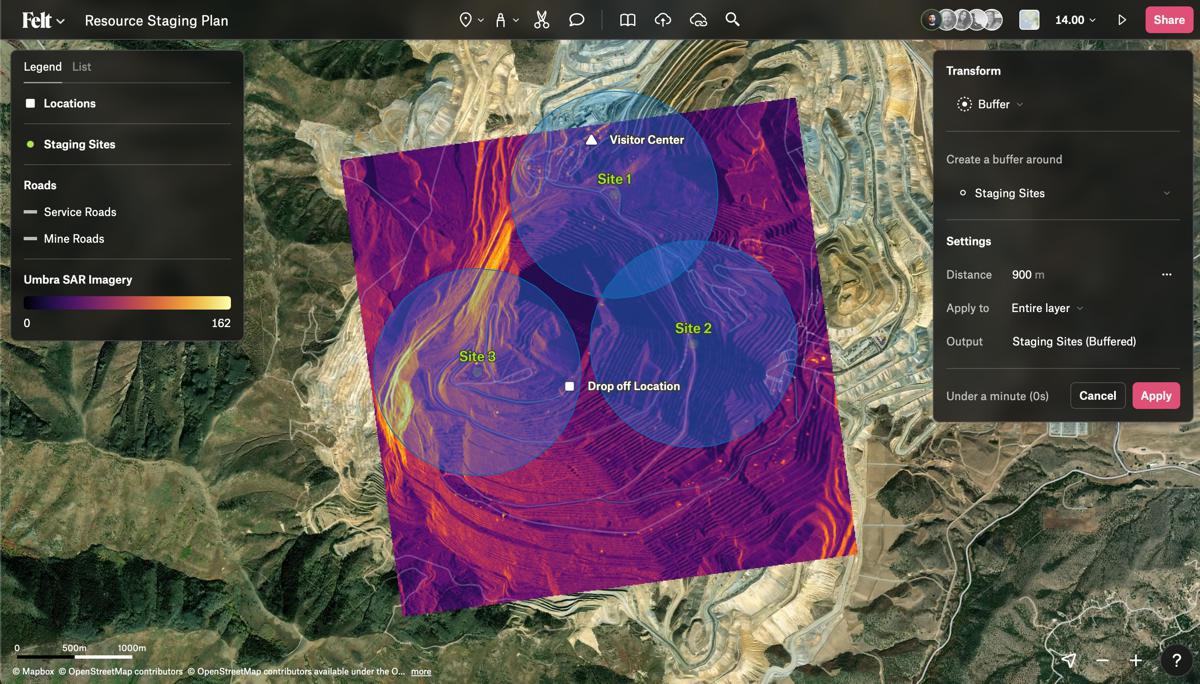
Now with spatial analysis features, users can manipulate and analyse geographic data, making it easier to unite and extract meaningful information from different datasets on a map. Combined with modern, web-based collaboration features, Felt 2.0 makes mapping workflows more iterative and accessible across organizations, and empowers better decision-making for the various industries that rely on maps to do their jobs.
Maps are increasingly a part of our lives and used to solve some of the world’s biggest challenges—from mitigating climate change, to city planning, scientific research, and more. Yet the tools many Geographic Information Systems (GIS) specialists and other professionals use are difficult and often desktop based, making the seamless and rapid collaboration users have grown to expect nearly impossible for mapping workflows.
With Felt 2.0, maps shift from something experts do in a silo to a participatory workflow, providing the same collaborative benefits as moving from Microsoft Word to Google Docs. Felt’s familiar UX allows anyone working in the context of maps to remove bottlenecks and increase the velocity of work, the creativity in which it gets done, and the diversity of the people doing it.
“It’s so easy to share a document, video, or design file today, yet despite how often we see them, maps remain incredibly difficult to make. We founded Felt to do what Google did for Docs, and what Figma did for design; maps aren’t just a static artefact anymore, they’re a live, collaborative experience,” said CEO and co-founder, Sam Hashemi. “With Felt 2.0, we’ve expanded on our foundation built for teams to meet the needs of GIS professionals. We’re proud to be changing the paradigms of what a map is and what it can accomplish.”
Trusted by GIS professionals and users from the largest global Architecture, Engineering, and Construction firms, top universities, and start-ups of all sizes, Felt has been helping teams visualize, share, and collaborate on geospatial data since its launch in 2021. This year, Felt became the first flagship sustaining member of the open source project, QGIS, and introduced a plugin so QGIS users can seamlessly share work across organizations. As industries across the board seek modern mapping software that integrates with current workflows, Felt is attracting new customers at a rapid clip, particularly across urban planning & development; energy; natural resource management; disaster response, and satellite imagery.
Introducing Felt 2.0
Felt’s fresh approach to mapping software removes complexity and uses AI to deliver faster workflows for GIS professionals and their teams. For example, users can Upload Anything to the platform, and—no matter the format—Felt reads, understands, and delivers an internet-fast visualization to the users’ workspace. Felt 1.0 brought mapping workflows to the browser and introduced the value of collaboration, shifting the need for organizations to rely on a single GIS expert and equipping entire teams with the right amount of insight and ability to provide seamless feedback.
Felt 2.0 marks the beginning of a new chapter for the platform, introducing its first set of powerful spatial analysis tools alongside a beautiful new UI experience for professionals. Spatial analysis empowers better decision-making, helping users answer questions like, “How many commercial buildings are within a certain radius of a flooding area?” or “Which sites are optimal for installing electric vehicle chargers?” With Felt’s fast and intuitive design, now anyone on a team can work with spatial tools, no matter their level of experience or background.
Felt is the best way to make maps on the internet. Try Felt 2.0 here.