GIS is becoming increasingly important across global construction, infrastructure and industrial technology, influencing how projects are visualised, coordinated, delivered and managed over time.
Managing extensive landscapes has traditionally required a compromise between scale and detail. Satellite imagery can cover large territories, while ground surveys reveal...
Most infrastructure stories in emerging markets are told as funding stories, built on the assumption that projects fail to happen because the capital is not there. The pa...
The Drone Was Never the Point Autonomous Sensor Workflows are Redrawing Infrastructure Drone Surveying For most of the past decade, the commercial drone story was a story...
When a software company releases books rather than product updates, it is easy to file the news under corporate housekeeping and move on. That would be a mistake in this...
Esri has made ArcGIS Velocity generally available for self-hosted ArcGIS Enterprise, and for infrastructure owners the significance is less about the software itself than...
For anyone who plans roads, bridges, pipelines, drainage systems or flood defences, the quality of the underlying water map has always set the ceiling on what the analysi...
Esri has published The Spatial Edge: The Strategic Advantage of GIS Skills Across Higher Education, a guide arguing that geographic information systems belong across an e...
Esri has confirmed the theme and headline speakers for its 2026 User Conference, the largest annual gathering of the geographic information system community, and the line...
Location data has quietly become one of the most influential forces shaping modern infrastructure, transport networks, utilities, emergency response systems and urban pla...
The geospatial technology sector has entered another phase of consolidation as VertiGIS completes its £87.1 million acquisition of 1Spatial, bringing together application...
The global infrastructure sector is undergoing a quiet but profound transformation. From digital twins and smart highways to climate resilience planning and urban mobilit...
The growing reliance on location intelligence across infrastructure, construction and transport is no longer a niche trend. It has become a core operational layer for how...
Geo Week’s decision to relocate its 2027 event from Denver to Salt Lake City marks more than a change of scenery. It signals a deliberate alignment with one of North Amer...
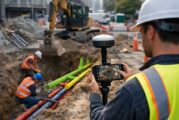
Underground utility strikes remain one of the most persistent and costly risks in construction. Despite decades of safety campaigns, improved regulations, and widespread...
Across construction, transport and infrastructure, software skills have quietly become as critical as concrete strength or asphalt mix design. Engineering teams now manag...
For years, high-resolution reality capture sat at the edge of construction workflows. Laser scanners were accurate but slow, mobile mapping systems were fast but complex,...
Across the global infrastructure sector, the most expensive problems are often the ones nobody can see. Utilities, highways agencies and contractors consistently face del...
The global geospatial sector is entering a decisive phase. From digital twins and infrastructure resilience to AI driven analytics and satellite intelligence, location da...
For governments, transport agencies and construction leaders managing critical infrastructure, data has become as valuable as concrete and steel. Modern highways, ports,...
The quiet digitisation of maritime chart production rarely makes headlines, yet it underpins everything from naval readiness and port construction to offshore energy and...
Location has always mattered. What has changed is the precision, accessibility and analytical power now available to interpret it. As climate pressures intensify, conflic...
Winter maintenance has always been a demanding responsibility, yet recent years have amplified the strain on road authorities. Climate volatility, ageing transport networ...
Sikkim, perched in the Himalayas and celebrated for its natural beauty, is charting a new path for sustainable and resilient urban development. With rapid urbanisation an...
Esri, the global leader in geographic information system (GIS) technology, has unveiled a major leap forward in marine mapping and data management. The latest capabilitie...
In the ever-evolving world of construction, few sectors are growing as rapidly, or as relentlessly, as data centres. With the rise of AI, cloud computing, and connected t...
Topcon Positioning Systems has unveiled a dedicated global business unit focused exclusively on geomatics, signalling a major shift in how the company approaches geospati...
Esri, a global leader in geographic information system (GIS) software, has published a ground-breaking book, GeoAI: Artificial Intelligence in GIS, which explores how art...
With urbanisation advancing at an unprecedented pace and the construction industry expanding worldwide, the effective management of construction and demolition (C&D)...
Access to basic sanitation remains one of the most pressing public health and social challenges in the world. Now, ground-breaking research from Australia has shed light...
Esri, the global leader in location intelligence, has unveiled Esri Mexico (Esri MX) as its new geospatial innovation centre for the country, taking over all products and...
In the race to make the digital world more inclusive, Maine is carving out a blueprint that could serve as a model for rural regions across the United States. For years,...
Modern cities are a maze of high-rises, tight alleyways, and oddly shaped rooftops—a visual playground for drones and satellites, but a headache for traditional remote se...
Esri, the global heavyweight in location intelligence, has just upped the ante with a trio of powerful new publications that blend storytelling, technical mastery, and ed...
In a move that’s set to shake up the landscape of geospatial technology, Esri has announced a deeper integration with Microsoft, leveraging the Azure OpenAI Service...
In a bold step towards democratising access to spatial intelligence, Esri has launched a streamlined e-commerce platform that places authoritative demographic data at use...
Designing with location in mind is no longer a luxury – it’s a necessity. And in a world where urban sprawl, sustainability pressures, and digital transformation collide,...
In construction, it all starts at ground level—literally. A perfectly poured slab is the first step in building anything from a humble bungalow to a glittering skyscraper...
In a bold stride toward shaping the future of urban mobility, SYSTRA Limited has selected TomTom as its go-to provider for digital maps, real-time traffic data, and locat...
As anticipation builds for the United States Geospatial Intelligence Foundation’s GEOINT Symposium 2025, all eyes are turning to Esri, the global heavyweight in GIS...
In a game-changing move for infrastructure planning and public policy, the American Society of Civil Engineers (ASCE) has unveiled its 2025 Report Card for America’...
This website uses cookies to improve your experience while you navigate through the website. Out of these, the cookies that are categorized as necessary are stored on your browser as they are essential for the working of basic functionalities of the website. We also use third-party cookies that help us analyze and understand how you use this website. These cookies will be stored in your browser only with your consent. You also have the option to opt-out of these cookies. But opting out of some of these cookies may affect your browsing experience.
Necessary cookies are absolutely essential for the website to function properly. These cookies ensure basic functionalities and security features of the website, anonymously.
Cookie
Duration
Description
cookielawinfo-checkbox-analytics
11 months
This cookie is set by GDPR Cookie Consent plugin. The cookie is used to store the user consent for the cookies in the category "Analytics".
cookielawinfo-checkbox-functional
11 months
The cookie is set by GDPR cookie consent to record the user consent for the cookies in the category "Functional".
cookielawinfo-checkbox-necessary
11 months
This cookie is set by GDPR Cookie Consent plugin. The cookies is used to store the user consent for the cookies in the category "Necessary".
cookielawinfo-checkbox-others
11 months
This cookie is set by GDPR Cookie Consent plugin. The cookie is used to store the user consent for the cookies in the category "Other.
cookielawinfo-checkbox-performance
11 months
This cookie is set by GDPR Cookie Consent plugin. The cookie is used to store the user consent for the cookies in the category "Performance".
viewed_cookie_policy
11 months
The cookie is set by the GDPR Cookie Consent plugin and is used to store whether or not user has consented to the use of cookies. It does not store any personal data.
Functional cookies help to perform certain functionalities like sharing the content of the website on social media platforms, collect feedbacks, and other third-party features.
Performance cookies are used to understand and analyze the key performance indexes of the website which helps in delivering a better user experience for the visitors.
Analytical cookies are used to understand how visitors interact with the website. These cookies help provide information on metrics the number of visitors, bounce rate, traffic source, etc.
Advertisement cookies are used to provide visitors with relevant ads and marketing campaigns. These cookies track visitors across websites and collect information to provide customized ads.