GIS is becoming increasingly important across global construction, infrastructure and industrial technology, influencing how projects are visualised, coordinated, delivered and managed over time.
National Highways has been announced as the only UK winner of an Esri Special Achievement in GIS Award, having won the accolade for its innovative use of geospatial techn...
Organizations in national, state, and local governments; architecture, engineering, and construction (AEC) sectors; and more are implementing 3D workflows for everything...
India’s city of Delhi is actually made up of two cities. To the north is Old Delhi, the historic city, and the south is New Delhi, the capital of India since 1947. It is...
VertiGIS, a leading global provider of spatial asset management solutions is pleased to announce the global launch of its VertiGIS Networks product line following its Nor...
Precisely, the global leader in data integrity, has announced the launch of MapInfo Pro v2023 – the latest release of its popular desktop Geographic Information System (G...
VertiGIS, a leading solution provider and software developer in the field of geographic information systems (GIS) and spatial asset management, today announced it has acq...
Topcon Positioning Systems has announced a new addition to its Topcon Solutions Store organization. Boyd Instrument and Supply of Horsham, Pennsylvania is now part of the...
Students across the nation learn about environmental and social concerns every day not just in the classroom, but from the communities in which they live. Complex issues...
Most current courses for software application development focus on technology and architecture rather than the tenets of interface design. Steve Jobs was quoted as saying...
Wejo Group Limited, a global leader in Smart Mobility for Good™ cloud and software solutions for connected, electric and autonomous vehicle data, today announced a...
The purpose of mapping has been to help people navigate around places in the physical world, something that has held true for centuries. But driving has evolved and, most...
In 1990, the government of Malta formed the Malta Information Technology Agency (MITA) with a mission to manage the implementation of public IT programs; since then, the...
In an increasingly digital and automated world, geospatial data plays a critical role in understanding the physical environment and powering the next generation of locati...
Hexagon’s Safety, Infrastructure & Geospatial division announced Ness Czech, a leading Czech system integrator and supplier of IT solutions and part of Ness Digital E...
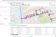
The Nevada Department of Transportation (NDOT) oversees 5,400 miles of highway and over 1,000 bridges, and is responsible for the planning, construction, operation, and m...
Climate change is compounding risks of food insecurity, displacement, and natural disasters across broad regions of the African continent, with vulnerable populations fac...
Otonomo Technologies Ltd., the platform powering the mobility economy, today announced that Geograma, a geographic information systems (GIS) and location intelligence ser...
Nextech AR Solutions Corp., a Metaverse Company and leading provider of augmented reality experience technologies and 3D model services has announced that ARway, a no-co...
Non-profits are increasingly taking a geographic approach to implementing their plans and ensuring the success of their goals. One non-profit organization recently used g...
From magnetic tapes to cloud computing, technology has advanced greatly over the 50-plus-year history of geographic information system (GIS) software. Today’s moder...
BlackSky Technology and Esri have developed an integration that gives Esri’s global customer base access to BlackSky’s dynamic tasking services through ArcGIS Online. The...
Smartphone navigation apps have given people a greater sense of personal freedom, allowing them to efficiently venture from one unfamiliar place to another, still knowing...
Wejo Group, a global leader in cloud and software analytics for connected, electric and autonomous vehicle data, today announced an expansion and extension of its existin...
Geo Connect Asia, the second edition of Southeast Asia’s flagship geospatial and location intelligence technology trade event, came to a successful close after a fruitful...
International events organiser Montgomery Asia announced today that Geo Connect Asia (GCA), the highly anticipated flagship geospatial and location intelligence industry...
Aeva®, a leader in next-generation sensing and perception systems, today announced that NASA’s Kinematic Navigation and Cartography Knapsack (KNaCK) Instrument project, a...
Capturing and sharing life’s experiences today often requires multiple platforms and tools, which can result in disjointed storytelling. To serve creators’ ne...
Esri UK has announced the full programme for its upcoming annual conference and exhibition on 17 May 2022, including speakers from Arcadis, Jacobs, Argent Related, Centre...
GeoPlace’s annual conference will take place on 10th and 11th May 2022, with the theme of ‘Connecting People to Places’. The event is online, reflecting appreciation show...
For years, staff at the City of Yakima have managed all the geographic data for the municipality and used imagery as a tool to support the city’s government, police...
Governments and businesses across the world are pledging to adopt more sustainable and equitable practices. Many are also working to limit activities that contribute to c...
VertiGIS, a leading geographic information systems (GIS) solution provider and software developer, has completed the acquisition of 100% of EDP Consult AB, an established...
EyeVi Technologies, an AI-driven mapping technology start-up, has raised €1.8 million in a seed round led by ff Venture Capital, with the participation of RKKVC, Decacorn...
When a winter storm battered a major city in the southwestern US and left millions in the community without power or drinking water, emergency responders relied on geogra...
Getting to Know ArcGIS Pro 2.8 It’s never been easier to get data, but for many organizations it is still challenging to make sense of all of it. Putting data on a...
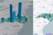
The global population grew by almost two billion people during the last 20 years—nearly 30 percent. Such growth is not evenly distributed over time or across space: the e...
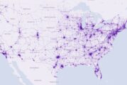
Orbital Insight’s fusion of multi-sensor geospatial data and state-of-the-art algorithms has been helping customers address critical concerns for years—from determi...
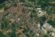
The Autodromo di Franciacorta is a race track in Castrezzato, Italy, which has hosted a variety of prestigious motorsport events throughout the years and most recently, t...
The American Society of Civil Engineers gives America’s foundational systems an overall grade of C-. Geospatial technology and digital twins are crucial building blocks f...
Gammon Construction Limited announces a collaboration between their innovation incubator Digital G Limited and Esri China (Hong Kong) Limited to co-develop GIS-based solu...
This website uses cookies to improve your experience while you navigate through the website. Out of these, the cookies that are categorized as necessary are stored on your browser as they are essential for the working of basic functionalities of the website. We also use third-party cookies that help us analyze and understand how you use this website. These cookies will be stored in your browser only with your consent. You also have the option to opt-out of these cookies. But opting out of some of these cookies may affect your browsing experience.
Necessary cookies are absolutely essential for the website to function properly. These cookies ensure basic functionalities and security features of the website, anonymously.
Cookie
Duration
Description
cookielawinfo-checkbox-analytics
11 months
This cookie is set by GDPR Cookie Consent plugin. The cookie is used to store the user consent for the cookies in the category "Analytics".
cookielawinfo-checkbox-functional
11 months
The cookie is set by GDPR cookie consent to record the user consent for the cookies in the category "Functional".
cookielawinfo-checkbox-necessary
11 months
This cookie is set by GDPR Cookie Consent plugin. The cookies is used to store the user consent for the cookies in the category "Necessary".
cookielawinfo-checkbox-others
11 months
This cookie is set by GDPR Cookie Consent plugin. The cookie is used to store the user consent for the cookies in the category "Other.
cookielawinfo-checkbox-performance
11 months
This cookie is set by GDPR Cookie Consent plugin. The cookie is used to store the user consent for the cookies in the category "Performance".
viewed_cookie_policy
11 months
The cookie is set by the GDPR Cookie Consent plugin and is used to store whether or not user has consented to the use of cookies. It does not store any personal data.
Functional cookies help to perform certain functionalities like sharing the content of the website on social media platforms, collect feedbacks, and other third-party features.
Performance cookies are used to understand and analyze the key performance indexes of the website which helps in delivering a better user experience for the visitors.
Analytical cookies are used to understand how visitors interact with the website. These cookies help provide information on metrics the number of visitors, bounce rate, traffic source, etc.
Advertisement cookies are used to provide visitors with relevant ads and marketing campaigns. These cookies track visitors across websites and collect information to provide customized ads.