GIS is becoming increasingly important across global construction, infrastructure and industrial technology, influencing how projects are visualised, coordinated, delivered and managed over time.
GEO Business 2025 is gearing up to take over ExCeL London from 4–5 June with a dynamic showcase of geospatial innovation, and the first wave of speakers has already set t...
Geo Connect Asia 2025 celebrates a successful show in Singapore having brought together geospatial visionaries, tech innovators, and infrastructure leaders from across th...
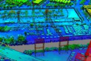
In a bold move poised to reshape the landscape of infrastructure analytics, Bentley Systems has teamed up with Google to turbocharge asset inspections using artificial in...
In a bold move to strengthen California’s disaster readiness, Esri has teamed up with the University of California San Diego’s ALERTCalifornia programme to em...
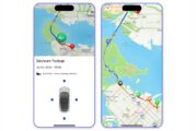
Navigating city streets can be a frustrating experience when unexpected road closures disrupt journeys, turning straightforward commutes into time-consuming nightmares. F...
In a significant stride towards enhancing geospatial data accessibility, Esri, the global leader in location intelligence, has unveiled the Content Store for ArcGIS. This...
The rapid evolution of geospatial technology is reshaping industries across the globe, and Geo Connect Asia (GCA) 2025 is set to take centre stage in showcasing its trans...
The Esri Developer & Technology Summit, now in its 20th year, is set to take centre stage in Palm Springs, California, from March 11–14, 2025. Recognised as the premi...
Topcon Positioning Systems has taken a significant leap forward with the expansion of its Topnet Live reference station network, adding 200 geodetic stations strategicall...
In an era where location intelligence is pivotal to decision-making, the partnership between TomTom and Esri has set the stage for transformative advances in geospatial t...
Spatial data science, the art and science of interpreting geographic information, is rapidly reshaping industries. From urban planning to climate research, its ability to...
In a bold move to modernise the construction landscape, Komatsu has merged Artificial Intelligence (AI) with its cutting-edge Smart Construction Edge platform, setting a...
Topcon Positioning Systems has made a substantial leap in its GNSS (Global Navigation Satellite System) correction services with an extensive expansion of its Topnet Live...
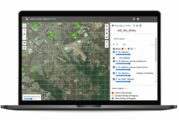
Blyncsy’s open API approach transforms how DOTs manage road infrastructure, offering flexibility and adaptability like never before. By publishing this highway data openl...
When it comes to making maps that aren’t just functional but also a pleasure to behold, Esri knows a thing or two—or maybe three. With the release of the third edit...
In the fast-paced world of public sector fleet operations, efficiency and accuracy are more critical than ever. Enter the ground-breaking partnership between Samsara Inc....
In a bold move set to redefine the digital landscape, Bentley Systems, a global leader in infrastructure engineering software, has announced its acquisition of Cesium, a...
In the windswept plains of Wyoming, where the skies stretch endlessly and the weather can shift in an instant, the state’s three major interstate highways play a crucial...
In an era where data security is paramount, especially within government operations, Esri’s latest achievement is a significant milestone. The global leader in location i...
On November 20, 2024, the world will come together to celebrate the 25th anniversary of GIS Day, a global event that highlights the power of Geographic Information System...
In an era where urban management and planning are becoming increasingly crucial, a ground-breaking project has emerged to illuminate the urban landscape of East Asia. Res...
Esri, the global leader in location intelligence, today announced the publication of Getting to Know ArcGIS Pro 3.2. The newest edition of this comprehensive guide introd...
TomTom’s maps and traffic data will power location-based services across Microsoft’s solutions, reaching hundreds of millions of people and organizations daily, and the c...
The Sanborn Map Company Inc., a leader in the geospatial industry, today announced the acquisition of the assets of VeriDaaS, a cutting-edge technology company specializi...
MATT3R®, an exciting new pioneer in Artificial Intelligence (AI) technology, has begun taking pre-orders for its K3Y™ device, which enables owners of Tesla vehicle...
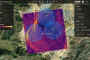
Millions of people live near active volcanoes that are constantly monitored for signs of an impending eruption. When one occurs, scientists and governments rely on data t...
Mobile mapping technology and AI-driven software expedite and improve roadway design and construction, while providing the data necessary for cost-effective, ongoing main...
Topcon Positioning Systems has announced strategic agreements with Bentley Systems and Worldsensing to integrate its advanced GNSS (Global Navigation Satellite System) te...
Leica Geosystems, part of Hexagon, introduces the Leica TerrainMapper-3 airborne LiDAR sensor, featuring new scan pattern configurability to support the widest variety of...
The Sanborn Map Company has unveiled an enhanced version of its Sanborn Image Analyst™, a web-based imagery data review application accessible through the Sanborn...
In the latest AgriTech innovation a team from MIT used machine learning to analyse satellite and roadside images of areas where small farms predominate and agricultural d...
Maxar Intelligence, a provider of secure, precise, geospatial intelligence, today announced that it received a contract to provide the National Geospatial-Intelligence Ag...
In a pioneering study published in Geo-spatial Information Science, a research group led by Yuyu Zhou from The University of Hong Kong developed an integrated framework t...
In 2021, Esri, the global leader in location intelligence, released ArcGIS Platform, a geospatial platform as a service (PaaS) for developers to integrate location capabi...
Trimble has announced the launch of SketchUp Viewer for Meta Quest 2, Meta Quest Pro and Meta Quest 3, a powerful, immersive way to view and present 3D SketchUp models in...
By learning about mapping skills and geography, students, teachers, and others can gain a better understanding of how the world’s most crucial issues, challenges, and opp...
To meet the growing demand for spatial analytics, Esri is extending its long-standing strategic collaboration with Microsoft through a unified analytics platform powered...
Digital transformation is rapidly changing the foundational processes powering the architecture, engineering, and construction (AEC) sectors. Industry leaders are relying...
Felt, the world’s first collaborative mapping tool, today launched Felt 2.0 with powerful data transformation tools that enhance its intuitive and professional platform....
This website uses cookies to improve your experience while you navigate through the website. Out of these, the cookies that are categorized as necessary are stored on your browser as they are essential for the working of basic functionalities of the website. We also use third-party cookies that help us analyze and understand how you use this website. These cookies will be stored in your browser only with your consent. You also have the option to opt-out of these cookies. But opting out of some of these cookies may affect your browsing experience.
Necessary cookies are absolutely essential for the website to function properly. These cookies ensure basic functionalities and security features of the website, anonymously.
Cookie
Duration
Description
cookielawinfo-checkbox-analytics
11 months
This cookie is set by GDPR Cookie Consent plugin. The cookie is used to store the user consent for the cookies in the category "Analytics".
cookielawinfo-checkbox-functional
11 months
The cookie is set by GDPR cookie consent to record the user consent for the cookies in the category "Functional".
cookielawinfo-checkbox-necessary
11 months
This cookie is set by GDPR Cookie Consent plugin. The cookies is used to store the user consent for the cookies in the category "Necessary".
cookielawinfo-checkbox-others
11 months
This cookie is set by GDPR Cookie Consent plugin. The cookie is used to store the user consent for the cookies in the category "Other.
cookielawinfo-checkbox-performance
11 months
This cookie is set by GDPR Cookie Consent plugin. The cookie is used to store the user consent for the cookies in the category "Performance".
viewed_cookie_policy
11 months
The cookie is set by the GDPR Cookie Consent plugin and is used to store whether or not user has consented to the use of cookies. It does not store any personal data.
Functional cookies help to perform certain functionalities like sharing the content of the website on social media platforms, collect feedbacks, and other third-party features.
Performance cookies are used to understand and analyze the key performance indexes of the website which helps in delivering a better user experience for the visitors.
Analytical cookies are used to understand how visitors interact with the website. These cookies help provide information on metrics the number of visitors, bounce rate, traffic source, etc.
Advertisement cookies are used to provide visitors with relevant ads and marketing campaigns. These cookies track visitors across websites and collect information to provide customized ads.