


Affordable Machine Control and Construction Solutions
It is well known that many small and medium construction companies have a slow technology adoption rate; some rely on old technologies, believing they are saving money by avoiding investments into new infrastructure, and others are not tech-savvy enough (as they may think), so any innovation sounds frightening.
Although both types of business owners can recognize the benefits of newer technologies, it is often difficult for technology departments in construction companies to have adequate budgets.
CHCNAV’s latest product releases mark the start of a global one-stop-shop solution for small and mid-size contractors: affordable, easy-to-use machine control and construction solutions that give them access to previously inaccessible GNSS RTK technologies for better data consistency and high accuracy during the entire construction project, for the entire job site, from GNSS rovers with CAD field surveying software to GNSS machine control systems for excavators and motor graders.
Establishing a GNSS positioning network, a cost-effective solution with optimal accuracy
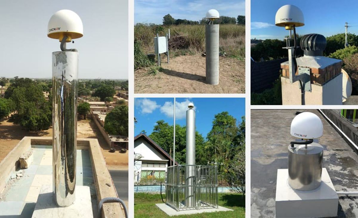
For nearly a decade, CHC Navigation has been deploying GNSS infrastructure around the world, ranging from a corrections service network at local sites, such as port automation, to regional coverage for construction engineering projects and national coverage for surveying applications. The combination of the CHCNAV’s server-based CPS RTK Network software, the P5 geodetic GNSS station, and the C220GR2 GNSS antenna (CORS), provides a powerful solution for any business for delivering ultimate, accurate, and uninterrupted positioning and navigation services.
Compared to traditional triangulation/traverse networks, the GNSS RTK network geometry is less critical, and the accuracy is higher and more reliable. Stations can be installed in areas where they are required, in convenient locations rather than on remote hilltops. Users set up their field receivers where they will be operating, get reference station data online, and then calculate their positions. A network of this type can be almost any size and shape.
Adding an RTK network to a construction site is a good idea because it corrects common errors in satellite navigation systems. This is done in real-time and on-site, which means that you never have to go out again for additional measurements or rework. Moreover, the RTK corrections network results in accuracy down to the centimetre, making measurements more reliable and accurate.
This solution can be utilized for construction works such as:
- site levelling and grading;
- installation of utilities such as pipelines, power lines, and other cables, and the construction of buildings, their landscapes, and access roads;
- staking out of road marks, pipelines, utilities, landscapes, fences, etc.;
- site mapping;
- deformation and monitoring (utility stability, ground movements, soil behaviour, surrounding structures, etc.);
- site exploration for new projects;
- etc.
GNSS RTK networks speed up operations in construction projects. They bring efficiency to construction sites, offering positioning accuracy and consistency of all surveying coordinates throughout the entire site and between different operators, regardless of the RTK rover’s brand.
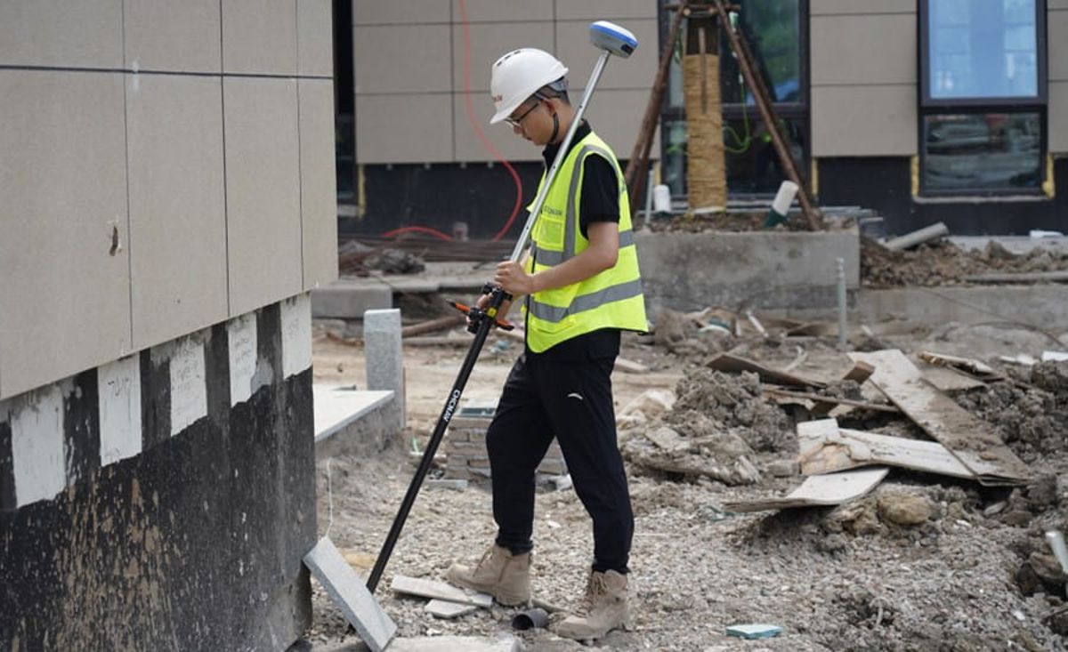
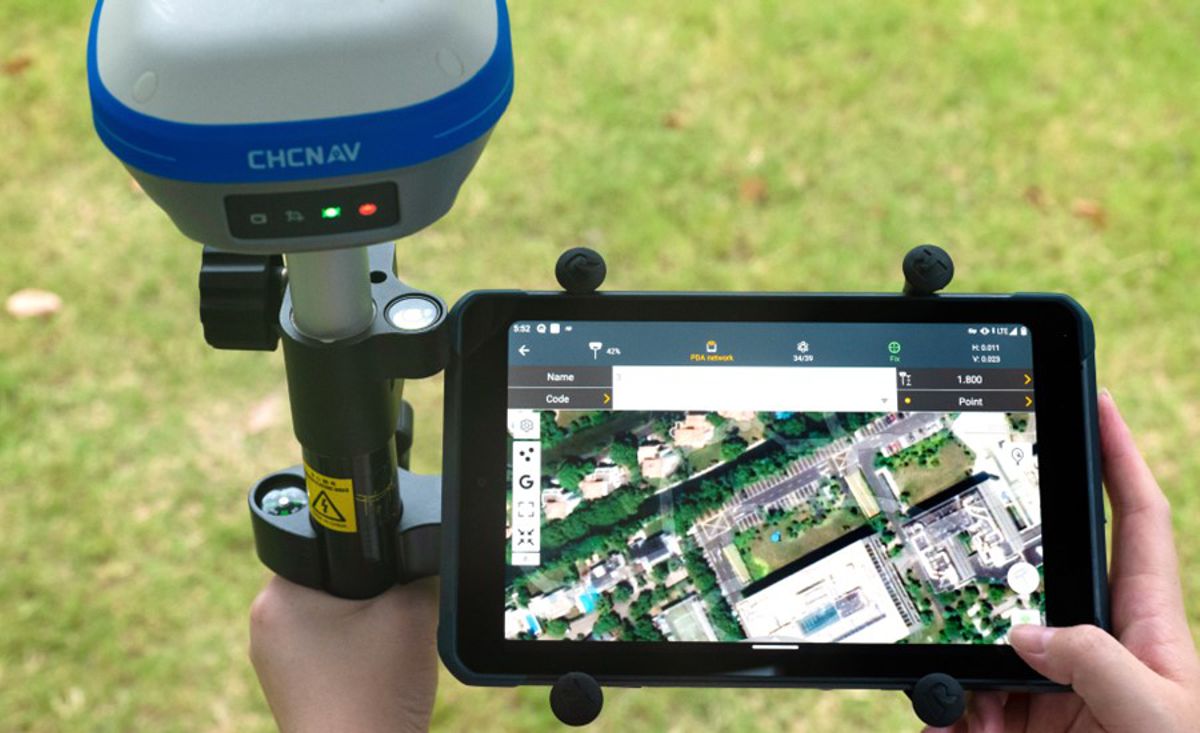
Enabling surveyors and all site foremen to own a survey-grade GNSS receiver
CHCNAV also provides GNSS receivers, controllers, total stations, and software tools that result in position accuracy on any job site. These systems are designed to operate in the most demanding environments and applications and are structured to boost productivity to bring growth to your construction business in the short and long run.
Construction companies looking for more accurate measurements can benefit from the i73+ compact GNSS receiver with a built-in UHF modem that achieves survey-grade, fixed RTK centimetre positioning, increasing the efficiency of point measurements by up to 20% and stakeout surveys by up to 30%. More accurate data means fewer errors during earthmoving applications, so less time is spent on finishing a project.
Similarly, the i83 smart and versatile IMU-RTK GNSS receiver is the perfect GNSS RTK survey tool with built-in connectivity modules such as wi-fi, Bluetooth, NFC, UHF and 4G modem, while the Landstar 8 land surveying and mapping App for Android makes onsite mapping and surveying projects quicker and more accessible due to its easy-to-use workflow manager and intuitive graphical interface integrating all surveying features for different applications, including construction surveying, control point measurement, native CAD project support, fast and accurate points, lines and surfaces stakeouts, road construction, GIS data acquisition, and more.
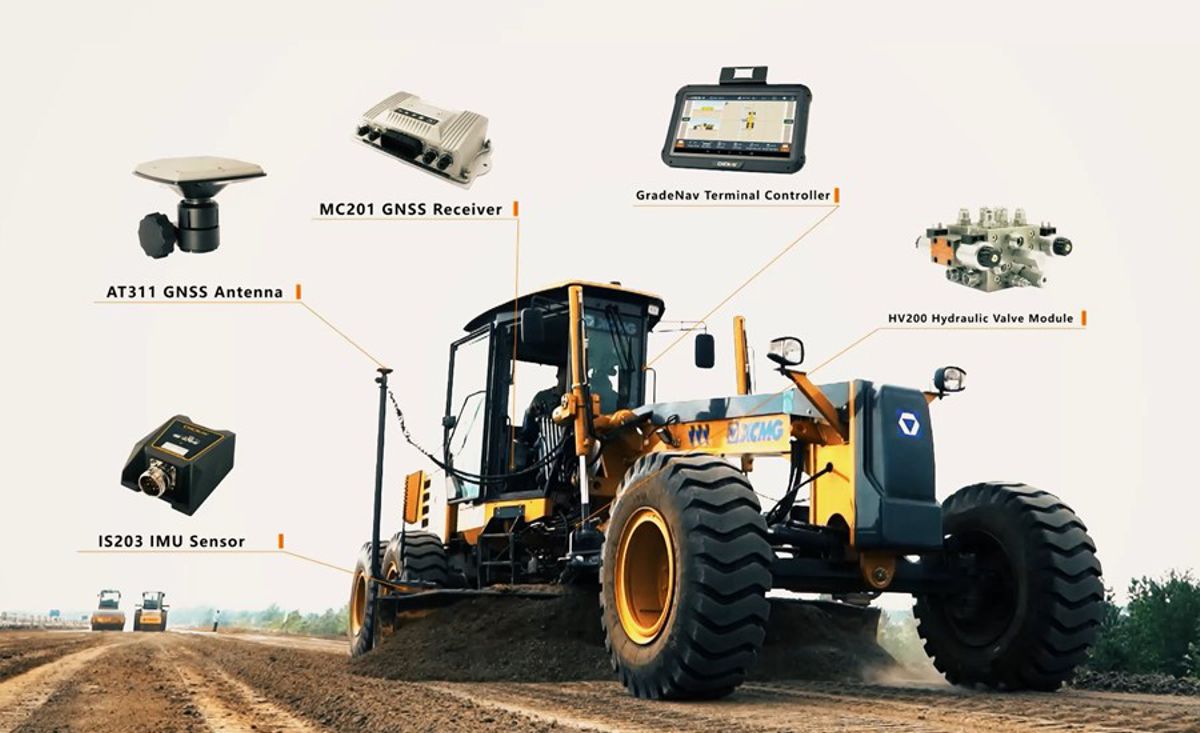
Making machine control systems available to contractors, no matter the size of their business
The CHCNAV’s latest automatic 3D grade control system, the TG63, improves the quality and efficiency of grading operations. The system combines dual-GNSS satellite positioning with inertial navigation to ensure the ultimate accuracy, regardless of the machine’s position. As a result, overall efficiency and productivity are increased significantly with the TG63, eliminating the need for manual staking while safety is always guaranteed for everyone involved.
The TG63 provides survey-grade data accuracy and reliability, without having to contract additional surveying capacity, as 3D design models and GNSS systems accurately position earthwork equipment. More than just robust GNSS technology, CHCNAV’s TG63 machine control solution is a highly productive tool that helps our clients complete their projects faster by bringing significant gains in productivity, accuracy, and speed to earthmoving applications.

Bringing accuracy to your construction project today
CHCNAV’s affordable, cutting-edge, easy-to-use, and complete machine control and construction solutions enable constructors to do their work faster, leading to better results, overall data consistency and less rework. These solutions are available everywhere on the planet and are guaranteed to bring your business growth in both the short and long term, providing you with professional surveying tools that add value to your machine control and construction tools.
To conclude, rather than viewing new technology in a negative light, construction companies should see it as an opportunity to improve efficiency and productivity. By investing in technologies, leaders in the construction sector can position themselves for future growth and mitigate the risk of being left behind by competitors. Once implemented, technology can be leveraged to increase profit margins and reduce costs over time.
CHC Navigation and its partners near you are open to discussing your operational challenges and how our solutions may help you address them.


