How New Caledonia’s Engineers Tamed a Landslide Without Rerouting
New Caledonia’s dramatic landscape is nothing short of breath-taking – a rugged blend of mountainous terrain, tropical downpours, and vibrant ecosystems. But for engineers tasked with building critical road infrastructure through such terrain, it’s less postcard-perfect and more of a logistical and geological minefield. Still, when a deep-seated landslide threatened to derail a major road project, a clever blend of digital tools, remote collaboration, and data-driven design saved the day – and the budget.
Hatch, the global engineering firm at the heart of this challenge, was managing the construction of a vital 2.2km access road slicing through steep hillsides. With high-cut slopes and volatile tropical soils in play, the project was already a juggling act. Then, in October 2021, Mother Nature threw a curveball.
When the Ground Gave Way
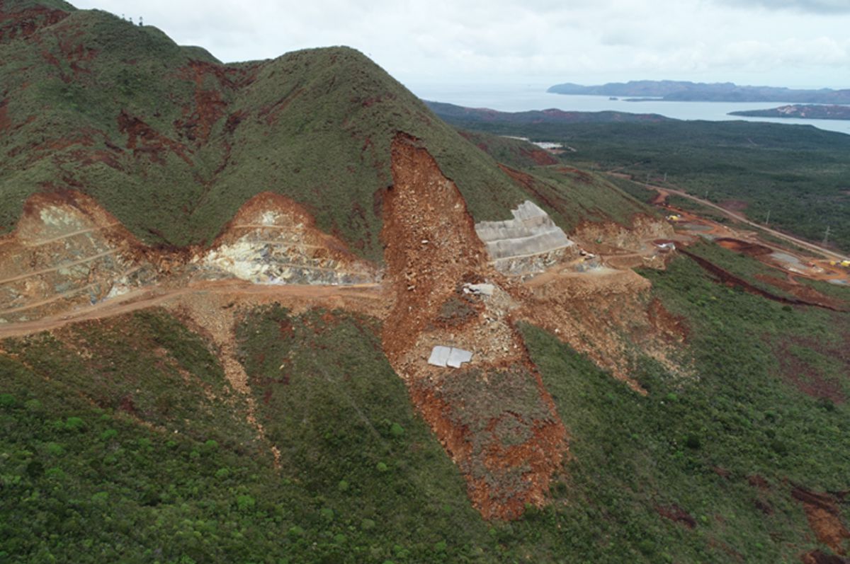
Late one afternoon, after the crew had clocked out, roughly 15,000 cubic metres of soil and rock decided to shift. A landslide swept across a 50-metre section of the road under construction. Fortunately, no one was hurt, but the incident halted work instantly. Within ten days, a secondary slide added another 10,000 cubic metres to the mess.
The kicker? This wasn’t even the steepest or highest section of the road.
With the clock ticking and budgets on edge, two obvious but costly solutions surfaced: build an entirely new road around the hazard or flatten the existing slope at a safer angle. Either choice would have strained the $50 million budget and pushed timelines back by months.
So, what now?
Enter the Digital Toolbox
Rather than panic or bulldoze ahead, Hatch turned to cutting-edge digital geotechnical tools from Seequent and Bentley Systems. These weren’t just fancy modelling programs – they became the backbone of the remediation strategy.
Simon Hope, principal geotechnical engineer at Hatch, put it plainly: “The software allowed for the landslide to be stabilised and slope conditions assessed so that the project could continue.”
Let’s break down the digital dream team:
- OpenGround: A cloud-based platform for collecting and managing geotechnical site data.
- Leapfrog Works: Used to develop 3D geological models.
- GeoStudio and PLAXIS: Heavy-hitters for stability analysis.
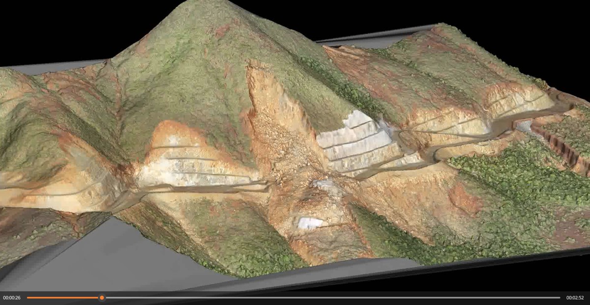
Initially, the team worked with traditional 2D cross-sections of the slope. That worked fine in some areas. But in others? Not so much. The road’s meandering path and variable rock formations made it impossible to grasp the bigger picture. Leapfrog Works changed that.
Hope noted: “Trying to interpolate between these [2D] sections was very difficult due to the meandering road geometry and variable geological conditions. A 3D Leapfrog model was therefore adopted to best model and assess the complex project conditions.”
Building the Bigger Picture
By developing a full 3D model using Leapfrog, the team could finally see what was happening beneath their boots. That model flagged a zone of particularly weak material at the base of the failed slope. Bingo – that was likely the trigger for the collapse above.
The compatibility between OpenGround, Leapfrog, and GeoStudio meant that updates could be made on the fly as construction progressed. And because OpenGround was cloud-based, Hatch engineers in Brisbane, Perth, Calgary and on the island could collaborate in near real-time, even during pandemic travel restrictions.
The perks didn’t stop at project continuation:
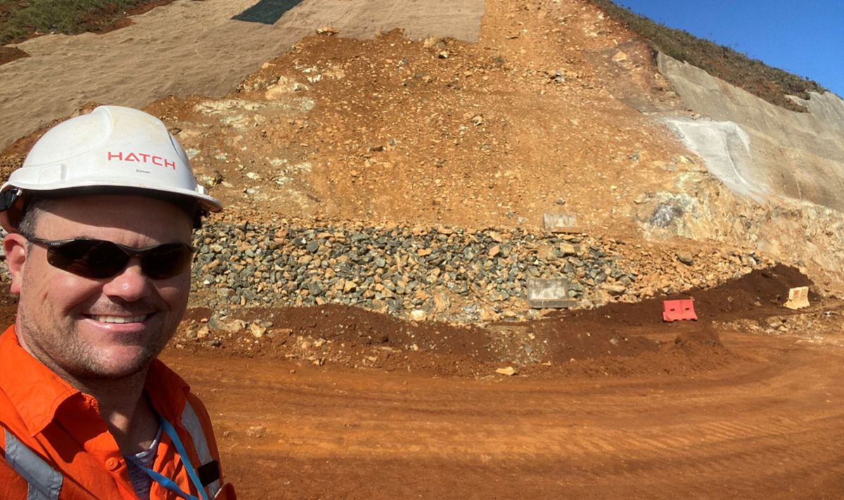
- Landslide remediation costs were halved.
- The need for a complete road realignment was avoided, saving time and cash.
- Carbon emissions were cut by 17,000 tonnes, thanks to reduced earthworks and remote collaboration.
- Sensitive rainforests were preserved, preventing ecological and cultural damage in a politically complex region.
Visuals Speak Louder Than Words
Beyond the numbers, there was another unexpected benefit: communication. With key stakeholders, including the project’s independent verifier, speaking French, and the technical jargon of geotechnical engineering in English, discussions were hitting language barriers.
The solution? Let the visuals do the talking.
“Leapfrog made the consolidation and visualisation of the site survey results and geological and geotechnical data a very powerful and important tool in the quick turnaround and progress of our project,” said Hope.
“The model was routinely presented in meetings to explain a concept or present technical data. As they say, a picture speaks a thousand words.”
Working Smarter, Not Harder
Faced with nature’s unpredictability, the Hatch team managed to dodge both disaster and delay. By using technology to diagnose the slope’s failure mechanism and reassess construction strategies on the go, they kept the road project alive and on track.
This wasn’t just about pushing pixels around in a 3D model. It was about using advanced geotechnical insight to guide practical, boots-on-the-ground decisions. And in places like New Caledonia, where every truckload of gravel and every dig must be weighed against its ecological and cultural footprint, that matters.
Engineering with Purpose
What’s perhaps most impressive here isn’t just the successful use of software, but how it allowed a diverse, multilingual, and globally distributed team to function like a single, cohesive unit. Real-time data sharing, collaborative decision-making, and smart visualisation made all the difference.
It also hints at a wider trend in infrastructure: where digital twins, cloud collaboration, and geo-visualisation aren’t just buzzwords – they’re lifelines.
In a world of increasingly complex terrain, weather, and stakeholder demands, the future of construction lies in intelligent modelling, smart data, and teams that can adapt swiftly and communicate clearly. Hatch’s work in New Caledonia is a shining example of all three.
Paving the Way Forward
Thanks to a forward-thinking approach, Hatch not only kept the road project on track, but also set a new benchmark for how to approach complex geotechnical problems. It’s a lesson in the power of preparedness, the strength of global collaboration, and the growing importance of integrating technology seamlessly into construction workflows.
This project reminds us that engineering success isn’t always about building the biggest bridge or the tallest tower. Sometimes, it’s about reading the land, adapting with finesse, and using every tool at your disposal to ensure progress doesn’t come at the cost of people, nature, or budget.