Looq AI Expands Global Partnerships to Accelerate Reality Capture
Looq AI has strengthened its position in the rapidly evolving world of ground-based reality capture, announcing seven new partnerships across North America, Europe, India, and the Middle East. This broadened global network marks a significant step in the company’s ambition to modernise how professionals capture, analyse, and manage field data for critical infrastructure.
The latest expansion arrives at a time when demand for fast, intelligent, and cost-effective data capture has surged. Surveyors, engineers, and utility operators increasingly face environments where traditional aerial methods fall short or fail to meet the necessary accuracy. Looq AI’s technology complements LiDAR systems, closes coverage gaps, and replaces outdated multi-tool processes with a far more streamlined, survey-grade approach.
Advancing The Future Of Ground-Based Reality Capture
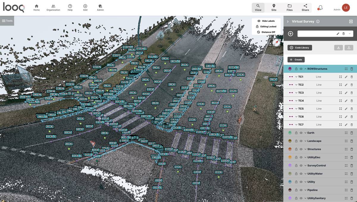
Looq AI’s platform centres on a handheld, ground-based capture system that blends innovative camera hardware with intelligent software. This creates a continuous workflow for creating, visualising, analysing, and sharing high-precision spatial datasets. Its capabilities support a wide range of topographic, utility, and infrastructure applications, ensuring users can work with confidence while keeping teams safe.
The system was designed to meet the growing need for rapid capture without sacrificing detail. Traditional methods, which often require multiple tools, repeated site visits, and an array of specialists, are increasingly challenging to justify for fast-paced engineering and utility projects. Looq AI’s platform helps reduce those inefficiencies, giving teams a reliable, survey-grade output while also minimising operational costs.
Dominique Meyer, CEO of Looq AI, emphasised the value of this user-focused approach: “Our mission is to empower professionals with tools that deliver uncompromising accuracy and measurable efficiency gains, often realised in just days, helping engineering firms reduce project costs and increase margins.”
Why Ground-Based Capture Matters
Infrastructure operators are under pressure to deliver precise, up-to-date spatial information to support asset maintenance, construction planning, and emergency response. Drone-based methods have expanded rapidly over the past decade, yet aerial capture is limited by flight restrictions, obstructed environments, and operational costs.
Ground-based systems address these challenges by:
- Capturing corridors where drones cannot safely fly.
- Operating in dense urban or forested environments.
- Filling data gaps in utility, road, and rail infrastructure mapping.
- Offering a more accessible and cost-effective method of achieving survey-grade outputs.
Recent advances in photogrammetry, edge computing, and AI-driven modelling have positioned ground-based capture as an essential complement to LiDAR, particularly for utilities, construction, energy transmission, and public works.
Strengthening The Partner Ecosystem Across The United States
Looq AI’s expanded presence in the United States includes several well-established partners that each bring regional expertise.
- AllTerra Central: Serving Texas, Oklahoma, Arizona, and New Mexico, AllTerra Central incorporates Looq AI’s survey-grade solutions to accelerate field-to-office workflows. Their experience in land surveying, geospatial operations, and infrastructure mapping positions them well to support Looq AI customers.
- LiDAholics: Based in Seattle, LiDAholics specialises in advanced scanning technologies. Their offerings complement Looq AI’s ground-based capture, ensuring professionals can deliver complete and accurate datasets for transportation, utilities, and industrial sites.
- Monsen Engineering: With coverage across Utah and Nevada, Monsen Engineering adds Looq AI to its established portfolio of surveying and mapping technologies. Their customers gain a rapid, reliable method of capturing reality data, particularly valuable for tight construction timelines.
- Terrain LLC: Terrain LLC strengthens Looq AI’s footprint across the Northeast United States. Their expertise in surveying, engineering, and infrastructure digitisation helps support utility clients and engineering firms seeking faster, more dependable project delivery.
Expanding Across Europe With Trusted Geospatial Leaders
Europe’s adoption of digital workflows continues to grow, and Looq AI’s new partnerships aim to accelerate that momentum.
- ECOGIS Sp. z o.o.: Operating across Poland and Croatia, ECOGIS has been a specialist in GIS projects, digital mapping, digital photogrammetry, and geodesy since 1992. Their capabilities enhance Looq AI’s reach across Central and Eastern Europe.
- Geometius: With more than 30 years of measurement expertise, Geometius serves professionals in the Netherlands, Belgium, and Luxembourg. Their integration of Looq AI technologies supports full digital workflows for surveying, mapping, and infrastructure monitoring.
These partners bring long-standing relationships with engineering firms, disaster response agencies, and infrastructure operators. Their adoption of Looq AI reflects a broader trend toward integrating ground-based systems into digital twin environments.
Growth Across India And The Middle East
Demand for digitised infrastructure data in India and the GCC continues to accelerate due to rapid urbanisation, utility modernisation, and large-scale investment in roads, power transmission, and urban redevelopment.
- IRIS STAR Technologies: IRIS STAR Technologies strengthens Looq AI’s reach across India and the Gulf states, supporting applications ranging from digital twins and geospatial surveying to infrastructure monitoring. Their cross-sector expertise is particularly important in markets where the scale of construction and utility expansion demands high-efficiency, survey-grade capture systems.
A Platform Built For Scalable Infrastructure Digitisation
Looq AI is positioning itself as a critical enabler of next-generation infrastructure management. The company’s innovations in camera technology make it possible to produce survey-grade 3D capture at a scale previously unattainable for many organisations.
Users across utilities, energy transmission, and engineering firms rely on the platform for topographic mapping, asset modelling, and risk assessment. By reducing manual effort and cutting down on repeated site visits, Looq AI provides a compelling value proposition for teams operating on tight schedules and budgets.
Additional industry research shows growing alignment with Looq AI’s mission. Reports from the American Society of Civil Engineers and the European Construction Industry Federation indicate that digital capture technologies are now seen as essential for improving productivity and reducing lifecycle costs across large infrastructure assets. With governments worldwide investing heavily in modernising transport and utility networks, demand for accessible, accurate, and rapid ground-based capture continues to increase.
The Future Of Infrastructure Digitisation
As Looq AI deepens its global footprint, it is clear the company aims to reshape expectations around field data workflows. The combination of intelligent software, advanced optics, and strong regional partnerships creates a solid foundation for broader adoption.
Professionals striving for consistent accuracy and operational efficiency now have access to a system designed specifically for the realities of ground-level work. Looq AI’s ongoing growth suggests that the future of infrastructure digitisation will rely increasingly on fast, safe, and scalable ground-based capture solutions.