XenomatiX Brings High Precision Profiling Down to Earth
Across the world, road agencies face a familiar dilemma. Networks are ageing, budgets are tightening, and the cost of deferred maintenance continues to climb. According to research from the World Bank and OECD transport studies, preventative maintenance typically costs several times less than rehabilitation once deterioration accelerates. Yet accurate condition data, the foundation of preventative maintenance, has historically required expensive specialist vehicles and complex measurement systems.
That imbalance has created a structural gap in infrastructure management. National highway agencies could afford survey fleets equipped with high-end scanning rigs, but municipalities and regional contractors often relied on visual inspection or manual surveys. The result has been inconsistent condition data and maintenance decisions based more on judgement than evidence.
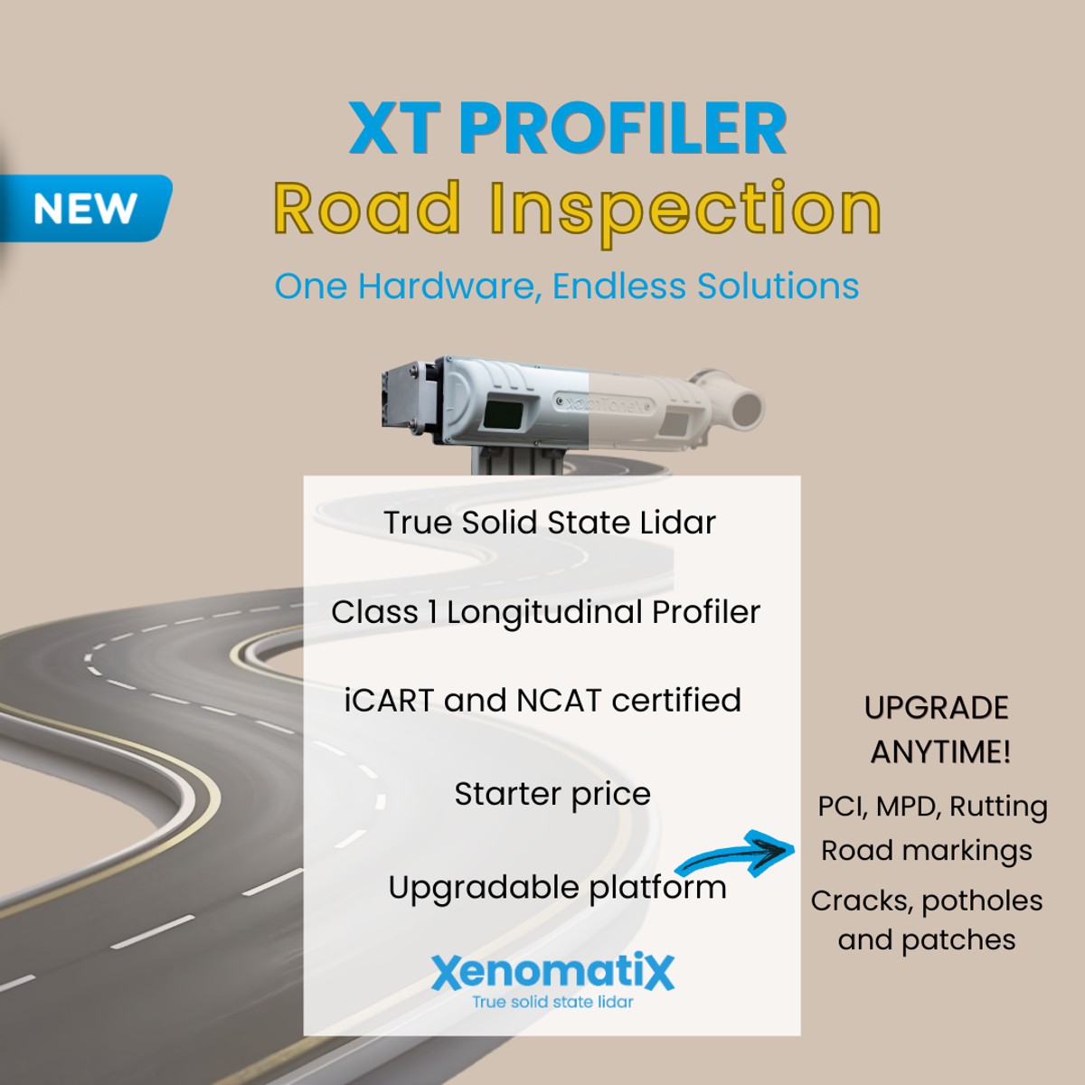
Belgian sensing technology firm XenomatiX has now introduced a new Class 1 longitudinal profiler called the XT Profiler. Rather than targeting national survey programmes, the system aims squarely at organisations that need certified data but lack the resources for a full road scanning platform. The move signals a broader shift within infrastructure technology, where high-precision measurement is transitioning from specialist capability to everyday operational tool.
A Practical Entry Point into Certified Road Measurement
The XT Profiler has been designed as a simplified implementation of XenomatiX’s existing 6D road scanning architecture. The company’s flagship systems combine geometry and reflectivity data to evaluate pavement condition, but such platforms historically represented a significant investment in hardware, training, and operational integration.
In practice, many users only require longitudinal profiling for indices such as ride quality and roughness. The International Roughness Index remains one of the most widely used performance indicators in asset management contracts and performance-based maintenance programmes worldwide. However, obtaining certified IRI measurements typically requires calibrated sensors operating under controlled conditions.
The new profiler aims to remove the operational barriers rather than merely reduce hardware size. Municipal engineers, contractors and consultants can deploy a measurement system capable of certified results without operating a dedicated survey vehicle fleet. By focusing on the most commonly required measurements first, the technology aligns with real-world procurement patterns rather than laboratory capability.
Crucially, the system retains compliance credentials. The device is ICART and NCAT certified, meaning data can be used for official road condition assessments and contract validation. For many agencies, certification is the dividing line between useful data and legally accepted measurement.
Solid State LiDAR Changes How Roads Are Measured
Traditional road profilers typically rely on laser spot sensors or line scanners. These methods measure vertical displacement along a narrow track beneath the vehicle and infer pavement characteristics from sampled points. While accurate at speed, they often struggle in urban environments where vehicles must stop frequently.
The XT Profiler instead uses true solid state LiDAR derived from XenomatiX’s broader sensing portfolio. Rather than sampling isolated points, the sensor continuously observes the road surface geometry while also capturing intensity information about material characteristics. The result is simultaneous geometric and surface data rather than a single vertical measurement trace.
This difference becomes especially relevant in city networks. Stop-and-go traffic has long been problematic for high-precision profilometry because sensors rely on motion to calculate surface shape. Solid state LiDAR removes that limitation, enabling so-called zero-speed measurements. Data quality remains consistent whether the survey vehicle travels at highway speed or pauses at traffic lights.
Urban authorities increasingly prioritise accessibility and ride comfort for buses and bicycles, making low-speed accuracy as important as motorway profiling. Technologies capable of stable measurement in congestion therefore have direct implications for urban transport planning.
From High End Surveying to Everyday Asset Management
Infrastructure digitisation has progressed unevenly across sectors. Building information modelling transformed design workflows, but asset management data collection often remained manual, particularly for local authorities. The missing link has been affordable measurement hardware capable of automated data capture.
The XT Profiler reflects a modular approach rather than a single monolithic system. Organisations can begin with longitudinal profiling and later unlock additional analytical capabilities through software upgrades. This removes the need to predict long-term technology requirements during procurement.
For smaller agencies, this approach reduces financial risk. A local authority might initially use roughness data to prioritise resurfacing programmes, then later incorporate additional analytics once staff workflows mature. Because the hardware remains constant, investment decisions become incremental rather than all-or-nothing.
The broader industry trend mirrors developments in construction robotics and telematics. Instead of buying maximum capability upfront, infrastructure operators increasingly deploy scalable sensing platforms that expand alongside operational maturity.
Data Consistency Becomes the New Infrastructure Currency
Certified measurement systems play a crucial role in performance-based maintenance contracts. Contractors paid on condition outcomes rather than activities rely on objective data to avoid disputes. Historically, only large national networks could support continuous measurement programmes due to cost constraints.
By lowering entry barriers, compact certified profiling systems may alter contracting practices. Smaller municipalities could implement performance specifications once measurement verification becomes affordable. This shift could standardise maintenance quality across networks rather than concentrating high data quality on motorways alone.
Consistent measurement also affects lifecycle planning. Pavement deterioration models depend heavily on historical condition data. When measurement intervals lengthen due to cost, predictive accuracy declines and budgets fluctuate unpredictably. More frequent surveys improve forecasting reliability, which in turn stabilises infrastructure funding requirements.
Integration with a Broader Sensing Ecosystem
The profiler sits within a wider sensing portfolio developed by XenomatiX. The company’s XenoTrack system already measures pavement indices such as IRI and PCI, while Xavia sensors combine LiDAR and camera data for 3D perception in mobility and industrial applications. Edge AI processing allows interpretation to occur within the sensor system rather than relying entirely on remote computation.
This convergence reflects a growing overlap between mobility sensing and infrastructure inspection. Technologies originally developed for automated vehicles are increasingly applied to asset management, safety analysis and smart city monitoring. As sensors become smaller and cheaper, the distinction between inspection equipment and operational equipment continues to blur.
A single vehicle platform may soon perform traffic monitoring, road condition measurement and safety analytics simultaneously. From a policy perspective, this convergence supports integrated transport management rather than siloed infrastructure programmes.
Implications for Contractors and Consultants
Contractors stand to gain operational flexibility from portable certified profiling. Smaller firms often rely on third-party survey providers to document completed works, introducing delays between construction and verification. Having in-house measurement capability can accelerate payment certification and reduce disputes.
Consultants likewise benefit from rapid data acquisition during design investigations. Early stage feasibility studies frequently require surface condition information but cannot justify full survey mobilisation. Lightweight certified systems enable preliminary engineering assessments without major logistical overhead.
Over time, this could influence procurement structures. Instead of separate survey contracts, measurement may become a routine component of construction workflows, much like GNSS positioning has already done for earthmoving operations.
Standardised Data for Smarter Maintenance Decisions
Infrastructure authorities worldwide are moving toward digital twins of road networks. Such models require consistent, repeatable measurement rather than occasional snapshots. The challenge has always been collecting sufficient data without excessive cost.
Affordable certified profiling contributes directly to digital asset strategies. When networks can be surveyed regularly, deterioration trends become visible early. Maintenance shifts from reactive repair to planned intervention, reducing lifecycle expenditure and improving safety outcomes.
From an economic standpoint, the significance lies less in the sensor itself and more in the decision-making it enables. Reliable measurement data forms the foundation of predictive maintenance, contract accountability and long-term investment planning.
A Wider Industry Turning Point
The introduction of smaller certified inspection tools suggests a maturing market. Early infrastructure digitisation focused on demonstrating technical capability. The current phase prioritises accessibility and scalability. Instead of proving that roads can be scanned accurately, the industry now seeks to make accurate scanning routine.
That shift parallels developments in surveying, where GNSS receivers moved from specialist instruments to standard site equipment over two decades. As measurement technologies commoditise, attention moves toward analytics and management outcomes rather than raw data collection.
The XT Profiler therefore represents more than another sensor launch. It highlights the transition of road condition measurement from niche expertise to operational necessity, enabling a broader range of infrastructure stakeholders to participate in data-driven maintenance.