Esri Charting the Future with ArcGIS Maritime for Hydrographic Intelligence
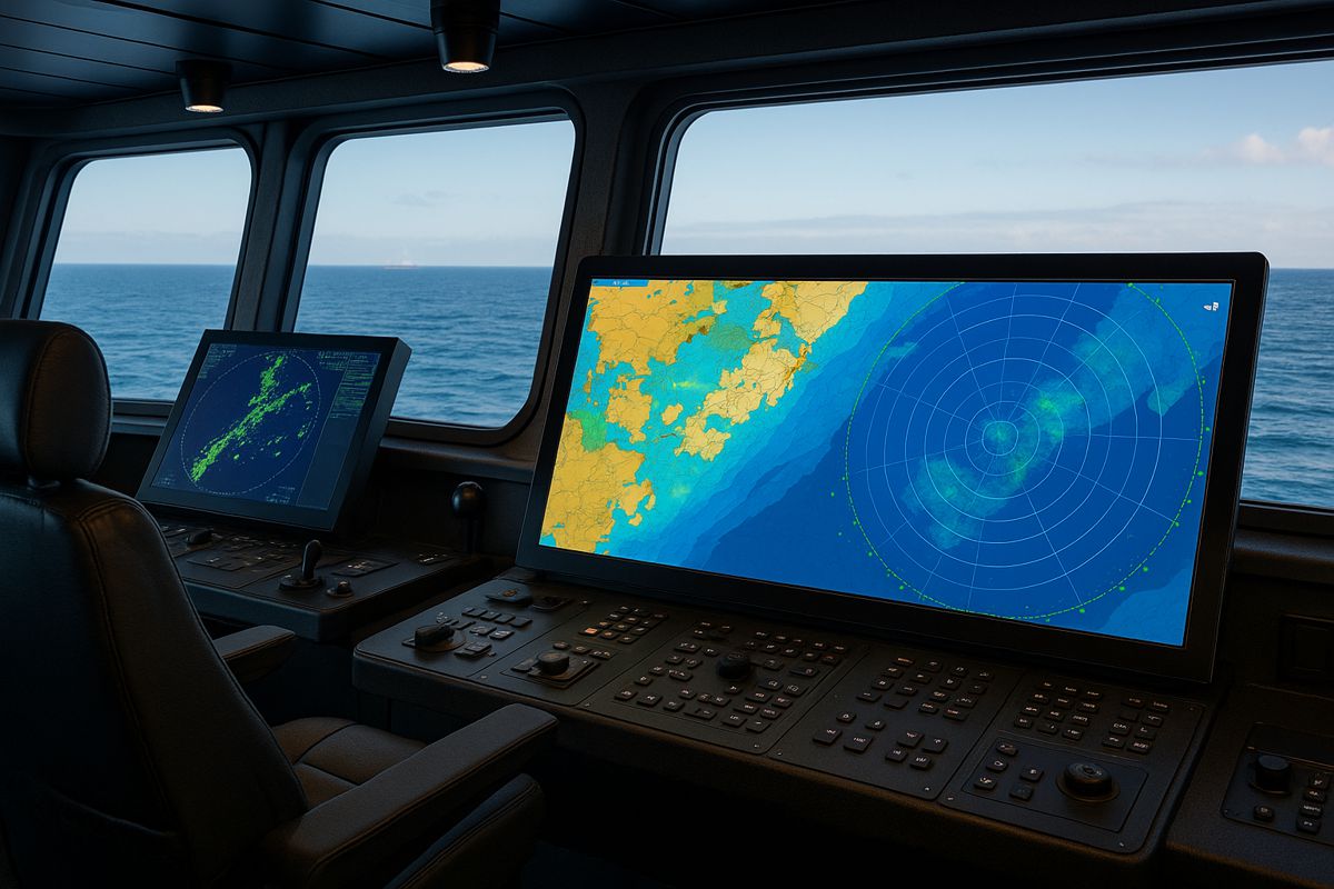
Esri, the global leader in geographic information system (GIS) technology, has unveiled a major leap forward in marine mapping and data management. The latest capabilities in ArcGIS Maritime now support the production of S-100 compliant nautical charts, marking a pivotal step in the evolution of hydrographic information.
This breakthrough enables maritime organisations to generate both S-57 and S-101 charts simultaneously, empowering them to fully leverage GIS technologies for safer, smarter, and more sustainable maritime operations.
The International Hydrographic Organization’s (IHO) new S-100 series of standards represents a transformational upgrade from the older S-57 framework. Designed as a modern, extensible model for marine spatial data, the S-100 standards accommodate not only electronic navigational charts but also bathymetric, meteorological, and oceanographic datasets. It’s a flexible, data-rich foundation that aligns seamlessly with GIS ecosystems, enhancing interoperability across the maritime sector.
The S-57 to S-101 Transition
Hydrographic offices worldwide are facing a period of dual responsibility. As they migrate towards the advanced S-100 series, many vessels still rely on S-57-based Electronic Chart Display and Information Systems (ECDIS). Until all fleets adopt the new framework, both chart formats will need to be produced concurrently, a practice the industry has dubbed the “dual fuel” phase.
This dual standard brings operational challenges. Managing parallel workflows can lead to redundancy, inefficiency, and increased costs. However, Esri’s ArcGIS Maritime aims to simplify this process. The software will continue supporting legacy S-57 charts while seamlessly introducing S-101 chart production capabilities. With S-57 slated for deprecation by 2034, the move to S-100-ready charting ensures future-proofed digital navigation and efficient transition management.
Enhancing Maritime Safety and Situational Awareness
At its core, the S-100 transition is about more than just compliance, it’s about advancing maritime safety, environmental stewardship, and economic resilience. By integrating S-100 charting with modern GIS technology, hydrographic offices can develop dynamic, data-driven tools that go far beyond traditional navigation.
Geoff Dean, Esri’s Senior Business Development Manager for National Government, highlighted the shift: “The core mission of maritime authorities like hydrographic offices is supporting safe navigation, but they are increasingly being called upon to support broader priorities like the blue economy and environmental stewardship. Combining the interoperability of the S-100 framework with modern GIS technologies like ArcGIS enables real-time decision-making, automation, and interagency coordination. These are key elements of a geospatial framework that prepares hydrographic offices for efficiently meeting the evolving demands placed on them.”
This evolution turns static nautical charts into living, data-rich resources. Ships, ports, and coastal agencies can access near real-time updates on seabed conditions, tide models, and vessel traffic, information critical for reducing accidents, protecting marine ecosystems, and optimising shipping routes.
From Charts to Geospatial Intelligence
ArcGIS Maritime is more than a mapping tool; it’s a full-fledged geospatial intelligence platform for the marine domain. By embracing the S-100 model, Esri’s solution transforms hydrography from a narrowly chart-centric discipline into a key pillar of global ocean data management.
Rafael Ponce, Principal Consultant at Esri, elaborated on the paradigm shift: “By transforming hydrography from a chart-centric discipline into a central pillar of marine geospatial information, this new framework will enable smarter navigation, better integration with GIS, and broader use of marine data for safety, sustainability, and economic development.”
With S-100-ready GIS, governments and maritime organisations can fuse nautical data with terrestrial and atmospheric datasets, creating a holistic geospatial view. This integration enhances coordination between agencies involved in shipping, coastal management, offshore energy, and marine research.
Supporting the Blue Economy
The world’s oceans drive much of the global economy, shipping, fisheries, offshore wind, and tourism all depend on accurate and up-to-date marine data. As the blue economy grows, the ability to collect, analyse, and share interoperable geospatial information becomes vital.
The S-100 standard supports this economic expansion by making marine data universally understandable and usable across platforms. Through ArcGIS Maritime, Esri enables nations and businesses to harness that data for decision-making, from protecting coral reefs to planning offshore wind farms or managing shipping corridors.
Moreover, integrating marine geospatial data into national GIS frameworks supports Sustainable Development Goals (SDGs), including those related to climate action, life below water, and resilient infrastructure. This alignment positions hydrographic offices as key contributors to global sustainability agendas.
Automation and the Power of GIS
One of the most exciting outcomes of combining S-100 with GIS is automation. With ArcGIS Maritime, hydrographic data processing can be streamlined, cutting down the time and labour traditionally required for chart updates. Real-time monitoring, AI-assisted data validation, and automatic conflict detection are just a few capabilities that make this possible.
The result is an intelligent maritime information ecosystem where data flows seamlessly between sources, systems, and users. Mariners benefit from accurate, continuously updated charts, while authorities can respond faster to hazards, environmental changes, or maritime incidents.
Showcasing Innovation at Hydro 2025
Esri will demonstrate these advancements at the upcoming Hydro 2025 Conference, taking place from 28–30 October in Liverpool, UK. Visitors to Esri’s booth (#7) will be able to experience live demonstrations of the new ArcGIS Maritime features and gain insights into how S-100 integration is shaping the next era of marine navigation.
Hydro 2025 serves as an ideal platform for Esri to engage with hydrographic professionals, policymakers, and technology partners. Attendees will explore how GIS-driven hydrography can streamline operations, foster collaboration, and support sustainable ocean development.
Esri’s Global Reach and Legacy of Innovation
Founded in 1969 in Redlands, California, Esri has become synonymous with location intelligence. Its technology underpins operations in hundreds of thousands of organisations worldwide, from government agencies and NGOs to Fortune 500 companies and universities. With offices and partners in over 100 countries, Esri’s footprint extends across six continents.
Through its pioneering GIS platforms, Esri continues to tackle complex global challenges by placing them in their most crucial context: location. The company’s commitment to innovation ensures that its customers can harness spatial data to make better decisions, improve efficiency, and drive sustainability.
A Smarter, Safer Maritime Future
The S-100 era is setting sail, and Esri’s ArcGIS Maritime is steering the course. By combining cutting-edge GIS with international hydrographic standards, Esri is helping the maritime sector navigate a future defined by digital transformation, sustainability, and interconnectivity.
As the world looks to the oceans for answers, the ability to map, analyse, and understand marine data will prove invaluable. With ArcGIS Maritime at the helm, the next generation of navigation and ocean management promises to be smarter, safer, and more sustainable.