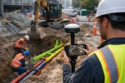
ArcGIS is becoming increasingly important across global construction, infrastructure and industrial technology, influencing how projects are visualised, coordinated, delivered and managed over time.
When a software company releases books rather than product updates, it is easy to file the news under corporate housekeeping and move on. That would be a mistake in this...
Esri has made ArcGIS Velocity generally available for self-hosted ArcGIS Enterprise, and for infrastructure owners the significance is less about the software itself than...
For anyone who plans roads, bridges, pipelines, drainage systems or flood defences, the quality of the underlying water map has always set the ceiling on what the analysi...
Across construction, transport and infrastructure, software skills have quietly become as critical as concrete strength or asphalt mix design. Engineering teams now manag...
Across the global infrastructure sector, the most expensive problems are often the ones nobody can see. Utilities, highways agencies and contractors consistently face del...
Location has always mattered. What has changed is the precision, accessibility and analytical power now available to interpret it. As climate pressures intensify, conflic...
The construction, infrastructure, and wider industrial sectors are experiencing a surge in demand for clearer data visibility, more reliable forecasts, and faster decisio...
Esri, the global leader in geographic information system (GIS) technology, has unveiled a major leap forward in marine mapping and data management. The latest capabilitie...
Esri, the global leader in location intelligence, has unveiled Esri Mexico (Esri MX) as its new geospatial innovation centre for the country, taking over all products and...
Esri, the global heavyweight in location intelligence, has just upped the ante with a trio of powerful new publications that blend storytelling, technical mastery, and ed...
In a move that’s set to shake up the landscape of geospatial technology, Esri has announced a deeper integration with Microsoft, leveraging the Azure OpenAI Service...
As anticipation builds for the United States Geospatial Intelligence Foundation’s GEOINT Symposium 2025, all eyes are turning to Esri, the global heavyweight in GIS...
In a bold move to strengthen California’s disaster readiness, Esri has teamed up with the University of California San Diego’s ALERTCalifornia programme to em...
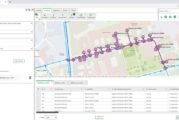
Navigating city streets can be a frustrating experience when unexpected road closures disrupt journeys, turning straightforward commutes into time-consuming nightmares. F...
In a significant stride towards enhancing geospatial data accessibility, Esri, the global leader in location intelligence, has unveiled the Content Store for ArcGIS. This...
In an era where location intelligence is pivotal to decision-making, the partnership between TomTom and Esri has set the stage for transformative advances in geospatial t...
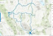
In the windswept plains of Wyoming, where the skies stretch endlessly and the weather can shift in an instant, the state’s three major interstate highways play a crucial...
In an era where data security is paramount, especially within government operations, Esri’s latest achievement is a significant milestone. The global leader in location i...
Esri, the global leader in location intelligence, today announced the publication of Top 20 Essential Skills for ArcGIS Online, a step-by-step guide through the process o...
Industry leaders in the architecture, engineering, and construction (AEC) sectors are increasingly relying on the interoperability of geographic information systems (GIS)...
In 2021, Esri, the global leader in location intelligence, released ArcGIS Platform, a geospatial platform as a service (PaaS) for developers to integrate location capabi...
To meet the growing demand for spatial analytics, Esri is extending its long-standing strategic collaboration with Microsoft through a unified analytics platform powered...
Digital transformation is rapidly changing the foundational processes powering the architecture, engineering, and construction (AEC) sectors. Industry leaders are relying...
Organizations in national, state, and local governments; architecture, engineering, and construction (AEC) sectors; and more are implementing 3D workflows for everything...
VertiGIS, a leading global provider of spatial asset management solutions is pleased to announce the global launch of its VertiGIS Networks product line following its Nor...
Students across the nation learn about environmental and social concerns every day not just in the classroom, but from the communities in which they live. Complex issues...
Business, government, and science organizations increasingly rely on drones, crewed aircraft, and satellites to capture imagery. Detailed imagery data provides visibility...
In an increasingly digital and automated world, geospatial data plays a critical role in understanding the physical environment and powering the next generation of locati...
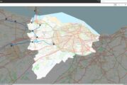
The Nevada Department of Transportation (NDOT) oversees 5,400 miles of highway and over 1,000 bridges, and is responsible for the planning, construction, operation, and m...
From magnetic tapes to cloud computing, technology has advanced greatly over the 50-plus-year history of geographic information system (GIS) software. Today’s moder...
BlackSky Technology and Esri have developed an integration that gives Esri’s global customer base access to BlackSky’s dynamic tasking services through ArcGIS Online. The...
For years, staff at the City of Yakima have managed all the geographic data for the municipality and used imagery as a tool to support the city’s government, police...
Getting to Know ArcGIS Pro 2.8 It’s never been easier to get data, but for many organizations it is still challenging to make sense of all of it. Putting data on a...
Orbital Insight’s fusion of multi-sensor geospatial data and state-of-the-art algorithms has been helping customers address critical concerns for years—from determi...
Global construction challenges, from affordable housing availability to infrastructure stress as a result of climate change, have increased in recent years. As a result,...
Esri, the global leader in location intelligence, today shared increased momentum with ArcGIS Field Maps, helping businesses transform how mobile workers perform duties t...
Esri, the global leader in location intelligence, announced today that zooom productions, a marketing agency specializing in sports and lifestyle brands, is among the lat...
Esri, a global leader in location intelligence, announced today that Relive, a company which developed an app that chronicles outdoor adventures and journeys by letting u...
Esri UK partner Symology has been recognised in the global Esri Partner Network awards, for its achievements using cloud-based GIS, by winning an ArcGIS Adoption Award. T...
Esri, the global leader in location intelligence, today released a new integration in its Site Scan for ArcGIS flight planner with business partner Airspace Link, Inc., t...
This website uses cookies to improve your experience while you navigate through the website. Out of these, the cookies that are categorized as necessary are stored on your browser as they are essential for the working of basic functionalities of the website. We also use third-party cookies that help us analyze and understand how you use this website. These cookies will be stored in your browser only with your consent. You also have the option to opt-out of these cookies. But opting out of some of these cookies may affect your browsing experience.
Necessary cookies are absolutely essential for the website to function properly. These cookies ensure basic functionalities and security features of the website, anonymously.
Cookie
Duration
Description
cookielawinfo-checkbox-analytics
11 months
This cookie is set by GDPR Cookie Consent plugin. The cookie is used to store the user consent for the cookies in the category "Analytics".
cookielawinfo-checkbox-functional
11 months
The cookie is set by GDPR cookie consent to record the user consent for the cookies in the category "Functional".
cookielawinfo-checkbox-necessary
11 months
This cookie is set by GDPR Cookie Consent plugin. The cookies is used to store the user consent for the cookies in the category "Necessary".
cookielawinfo-checkbox-others
11 months
This cookie is set by GDPR Cookie Consent plugin. The cookie is used to store the user consent for the cookies in the category "Other.
cookielawinfo-checkbox-performance
11 months
This cookie is set by GDPR Cookie Consent plugin. The cookie is used to store the user consent for the cookies in the category "Performance".
viewed_cookie_policy
11 months
The cookie is set by the GDPR Cookie Consent plugin and is used to store whether or not user has consented to the use of cookies. It does not store any personal data.
Functional cookies help to perform certain functionalities like sharing the content of the website on social media platforms, collect feedbacks, and other third-party features.
Performance cookies are used to understand and analyze the key performance indexes of the website which helps in delivering a better user experience for the visitors.
Analytical cookies are used to understand how visitors interact with the website. These cookies help provide information on metrics the number of visitors, bounce rate, traffic source, etc.
Advertisement cookies are used to provide visitors with relevant ads and marketing campaigns. These cookies track visitors across websites and collect information to provide customized ads.