Deep Learning Transforms Vehicle Tracking for Critical Infrastructure
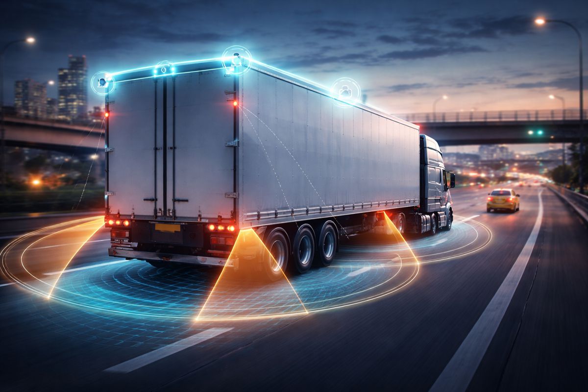
Safeguarding nuclear materials has always demanded vigilance, precision and a fair bit of patience. Now, researchers at Oak Ridge National Laboratory are reshaping how that vigilance works in practice. By combining drone imagery, ground-based cameras and advanced deep learning models, the team has developed an algorithm capable of identifying unusual vehicle activity that may signal illicit transport, including the movement of nuclear materials.
For the global construction and infrastructure community, this is not merely a laboratory curiosity. Critical infrastructure, from ports and highways to energy facilities and logistics hubs, increasingly sits at the intersection of security and data science. As transport networks become more digitised, the ability to detect abnormal patterns of vehicle behaviour in near real time is fast becoming a cornerstone of national resilience. ORNL’s work illustrates how artificial intelligence can move beyond static object recognition and into dynamic, long term behavioural analysis.
From Vehicle Recognition to Patterns of Life
The foundation of this research lies in a previously developed ORNL technology focused on recognising specific vehicles from side views. While useful, conventional vehicle re identification systems have often relied on tightly controlled conditions. They typically require images captured from similar angles or perspectives to confirm that two images depict the same car or truck. In the real world, that constraint quickly becomes a limitation.
ORNL’s latest deep learning model breaks free of that rigidity. Instead of depending on matching angles, it can process images captured from almost any viewpoint and at varying distances. As lead researcher Sally Ghanem explained: “The majority of the current re-identification models require specific views of the car from the same angles. But our model does not have any of these limitations,” Ghanem said. “We can basically put in any view, from any distance, and determine if it is the same vehicle.”
In practical terms, that means the roof of a truck captured by a drone can be accurately matched with a side profile recorded by a roadside camera. For security agencies monitoring sensitive facilities, that flexibility is transformative. Vehicles no longer need to cooperate with the camera’s angle. The system adapts to the vehicle.
Infrastructure Security
Across Europe, North America and Asia, governments are tightening oversight of critical infrastructure as part of broader national security and resilience strategies. The International Atomic Energy Agency has repeatedly emphasised the importance of robust safeguards and monitoring frameworks to prevent the diversion of nuclear materials. Digital tools capable of identifying suspicious shipment activity can complement physical inspections and regulatory compliance systems.
Infrastructure operators face similar challenges. A surge in overnight truck movements at a facility that normally operates during daylight hours may indicate nothing more than a change in shift patterns. Then again, it could signal something more concerning. By establishing a baseline of routine traffic patterns over time, ORNL’s software creates what researchers describe as a “pattern of life.” Deviations from that baseline trigger closer scrutiny.
This shift from reactive inspection to proactive anomaly detection mirrors broader trends in infrastructure management. Just as predictive maintenance systems monitor vibration data to anticipate equipment failure, AI driven surveillance models can monitor traffic flows to anticipate risk. In both cases, the principle is the same. Learn what normal looks like, then flag what does not.
Training the Algorithm at Scale
Achieving this level of accuracy required an expansive and carefully curated training dataset. The ORNL team trained the model on hundreds of thousands of publicly available images captured by surveillance cameras, ground sensors and drones. To broaden its exposure, they also introduced computer generated imagery based on detailed vehicle specifications.
ORNL researcher John Holliman constructed 3D digital models of numerous car and truck brands. Paint colours, lighting conditions and viewing angles were varied to simulate a wide spectrum of real world scenarios. Crucially, the dataset included older vehicle models that are often underrepresented in standard recognition libraries. That decision reflects a practical reality. Illicit activity is not typically conducted using brand new, easily traceable vehicles.
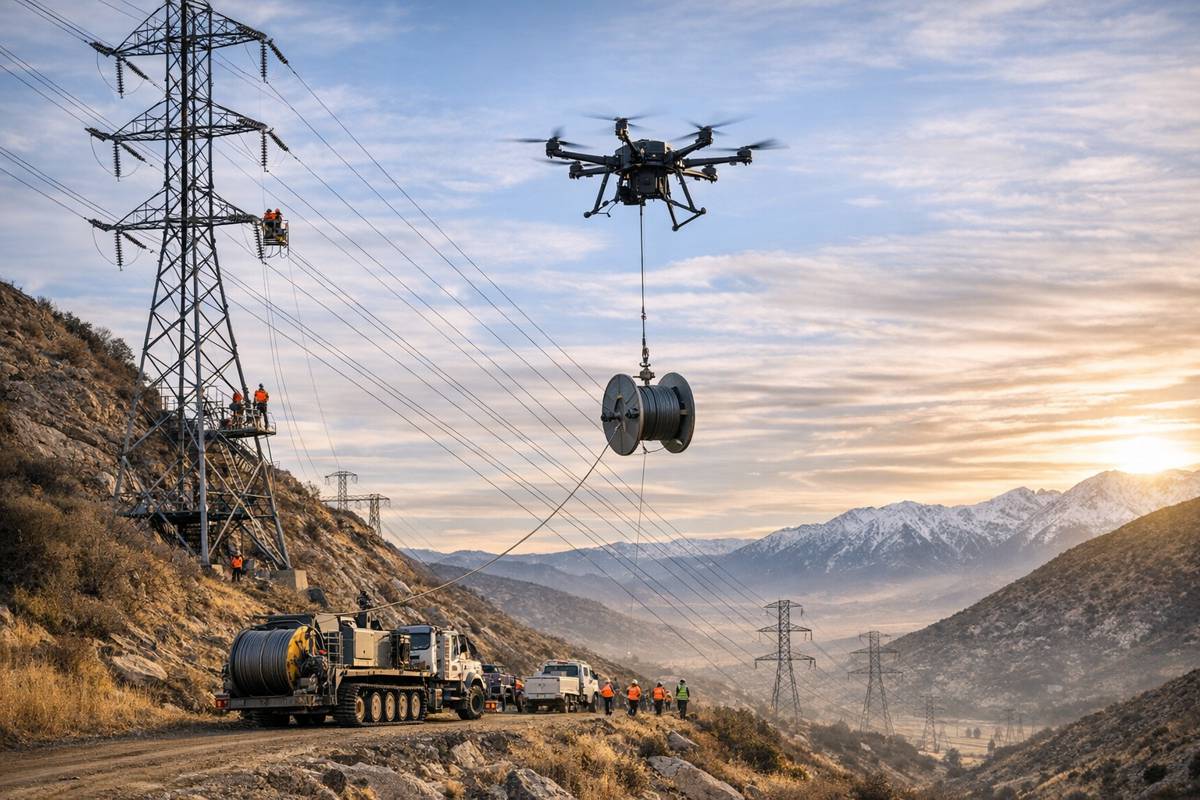
The team further enriched the dataset through six dedicated data collection campaigns at three intersections on the ORNL campus. These locations were selected because vehicles entered and exited via the same route, allowing consistent multi angle capture. Drones were deployed to circle vehicles and capture images from multiple heights and perspectives. According to Ghanem: “We’re using drones to improve the training data because they are very flexible,” Ghanem said. “Drones can circle a vehicle and change their distance to get many angles, so we can simulate images collected from a satellite or at road level.”
Embracing Imperfection to Improve Accuracy
Rather than filtering out imperfect data, the researchers leaned into it. Blurry footage caused by electrical or magnetic interference was included. Vehicles partially obscured by tree branches or traffic lights were kept in the dataset. Night time images and low resolution captures were deliberately integrated.
As Ghanem noted: “The more low-resolution images we include, the more robust the model.” This approach reflects a broader shift in AI research. Systems trained only on pristine, high resolution imagery often falter when confronted with messy, real world conditions. By exposing the algorithm to challenging inputs from the outset, the team ensured it could handle degraded or incomplete data with confidence.
To reduce bias, repetitive images of identical angles or vehicle types were removed. The algorithm was also trained using both correct and incorrect image pairs, with correct matches intentionally representing different perspectives. As Ghanem explained: “By retraining the model on challenging pairs, we make it more capable of tricky matches.” That deliberate exposure to ambiguity helps prevent the system from defaulting to superficial similarities, such as matching vehicles solely because they share a colour or body shape.
Measured Performance and Neural Network Architecture
Following training, the model was tested against 10,000 image pairs, evenly split between correct and incorrect matches. The result was more than 97 percent accuracy. In the realm of computer vision, especially under variable lighting and viewpoint conditions, that figure is notable.
The system leverages a series of neural networks designed to operate in tandem. These computational models, loosely inspired by the structure of the human brain, do more than compare pixels. They extract distinguishing features, correlate them across viewpoints and, over time, derive patterns from repeated observations. The result is not only identification but behavioural insight.
Ghanem underscored the strategic importance of this capability: “The project supports nuclear nonproliferation, enabling us to identify whether shipment activities are happening at a specific place.” That statement positions the research squarely within global nonproliferation efforts led by the US Department of Energy and international partners.
Broader Applications Across Transport Modes
While the immediate focus is nuclear material monitoring, the underlying methodology has far wider implications. The algorithm is precise enough to track individual vehicles distinguished by stickers, dents or other minor features across multiple sensor types. Repeated visits to a location can be flagged even if the vehicle approaches via different routes on each occasion.
Researchers are exploring the integration of non visual sensor data, potentially expanding the system’s capabilities to include acoustic, magnetic or other environmental inputs. Beyond road vehicles, the same principles could be applied to maritime shipping and aviation logistics. Ports and airports already rely on a mix of CCTV, satellite imagery and tracking systems. An AI model capable of fusing these inputs into a coherent anomaly detection framework could significantly enhance oversight.
For infrastructure investors and policymakers, the commercial relevance is clear. As global trade volumes grow and supply chains become more complex, regulators face mounting pressure to ensure that hazardous or illegal materials are not concealed within legitimate shipments. AI driven surveillance systems may become as integral to modern logistics hubs as weighbridges and customs scanners.
Infrastructure, Security and the Digital Convergence
The High Flux Isotope Reactor at ORNL, a user facility of the DOE Office of Science, served as one of the environments for drone based data collection. Although the reactor itself is a specialised research facility, the lessons extend well beyond its perimeter.
Transport corridors, industrial parks and energy installations worldwide are converging with digital technologies at pace. Sensors, drones and cameras now form part of the operational fabric. Yet data alone is not enough. Without advanced analytics, vast streams of imagery remain little more than archived footage. ORNL’s work demonstrates how those streams can be transformed into actionable intelligence.
For the construction and infrastructure sector, the message is straightforward. As projects become more connected and assets more instrumented, cybersecurity and physical security are no longer separate disciplines. They intersect through data. Deep learning systems that interpret vehicle behaviour may soon sit alongside structural health monitoring tools and smart traffic management platforms in the digital infrastructure toolkit.
A Step Toward Smarter Safeguards
This research, funded through ORNL’s Laboratory Directed Research and Development programme, signals a maturation of AI in the service of national and infrastructure security. It moves beyond static recognition toward contextual understanding. It acknowledges the messy realities of field data. And it demonstrates that with careful training and bias mitigation, deep learning systems can achieve high levels of reliability in complex environments.
As global infrastructure networks continue to expand and digitise, the ability to detect subtle anomalies in transport behaviour will likely become indispensable. Whether monitoring nuclear shipments, hazardous materials or critical supply chains, AI driven pattern recognition stands poised to play a defining role in the next chapter of infrastructure security.
![]()