Topcon CR S1 Brings Everyday Reality Capture to Infrastructure Workflows
For years, high-resolution reality capture sat at the edge of construction workflows. Laser scanners were accurate but slow, mobile mapping systems were fast but complex, and data processing required specialist skills. The result was predictable. Surveys happened at milestones rather than continuously, meaning project teams worked from snapshots instead of a living digital record.
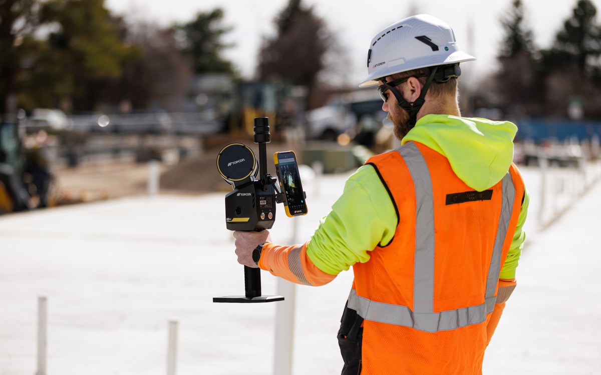
The arrival of compact multi-sensor handheld systems is changing that equation. Topcon Positioning Systems has introduced the CR-S1, a portable scanning device combining LiDAR, panoramic imaging, visual SLAM cameras and GNSS positioning into a single unit. The significance lies less in the hardware itself and more in what it enables. Infrastructure teams can now gather dense spatial data as part of routine site activity rather than as a dedicated survey exercise.
This matters across the lifecycle of an asset. Contractors increasingly rely on digital twins to manage risk, coordinate trades and verify progress. Without frequent and reliable spatial capture, those twins drift away from reality. The industry has long talked about “as built equals as designed”. In practice, the gap between the two often widens the moment construction begins.
A handheld capture system designed for daily use moves reality capture from a specialist discipline to an operational habit. Instead of dispatching survey crews periodically, engineers and supervisors can collect data while walking the site. That shift changes how projects are monitored, disputes are resolved and quality is verified.
The Multi Sensor Approach And Why It Matters
Traditional scanners rely on a single measurement principle. LiDAR provides geometric accuracy, photogrammetry provides visual context, and GNSS provides positioning. Combining them has typically required multiple instruments and post-processing workflows.
The CR-S1 integrates these measurement methods. LiDAR records geometry, panoramic cameras capture imagery, visual SLAM determines relative positioning, and GNSS ties the dataset into global coordinates. In simple terms, each sensor compensates for the weaknesses of the others. LiDAR struggles in featureless corridors, SLAM struggles outdoors without references, and GNSS struggles indoors. Together, they create a continuous spatial record across environments.
Topcon positions the device within its Capture Reality portfolio as a higher performance option alongside the CR-S2, with increased point cloud density, extended scanning range and improved panoramic imaging. That specification is particularly relevant in infrastructure environments where geometry varies dramatically between open roads, tunnels and urban corridors.
Ron Oberlander, head of the Topcon Geomatics Platform, explained the philosophy behind the ecosystem: “Customers are looking for flexibility and efficient workflows, and our scanning portfolio and software are designed to support these needs through simplified processes, open integrations and mixed-fleet compatibility,
“With Collage serving as the central data hub supporting inputs from multiple sensors, users can obtain accurate, detailed information for decision-making.”
The emphasis on mixed fleets reflects an industry reality. Contractors rarely operate a single vendor stack. They combine total stations, GNSS rovers, UAV mapping and machine control systems. A capture device that integrates rather than replaces existing equipment has a stronger chance of adoption.
Connected Software Rather Than Isolated Data
Hardware is only half the story. Reality capture has historically failed at scale because data stayed trapped inside proprietary software environments. Processing large point clouds required powerful desktops, specialised training and time.
Topcon’s workflow centres on the Collage software ecosystem. MAGNET Flow operates on mobile devices, MAGNET Bridge handles SLAM data processing on desktop systems, and Collage Web allows cloud-based visualisation directly in a browser. Through the Collage Cloud Connector, datasets synchronise automatically and can integrate with Autodesk and ClearEdge3D platforms.
This reflects a broader shift in the industry. The value of spatial data is no longer in its collection alone but in its accessibility. Engineers, planners and clients need to inspect conditions without installing specialist software. Browser-based viewing removes friction from collaboration, particularly on multi-stakeholder infrastructure projects.
Cloud visualisation also supports distributed project teams. With international supply chains and remote project management now standard practice, the ability to review site conditions from anywhere has moved from convenience to necessity. The industry learned during pandemic disruptions that physical presence cannot be the only mechanism for verification.
Positioning Accuracy And The Role Of RTK Corrections
Handheld mapping systems historically sacrificed absolute accuracy for speed. SLAM techniques create internally consistent datasets but can drift relative to real world coordinates. Infrastructure projects, however, depend on positional precision measured in centimetres rather than metres.
The CR-S1 addresses this by connecting to Topnet Live RTK GNSS corrections. Real Time Kinematic positioning provides centimetre-level accuracy by referencing fixed base stations. When combined with SLAM trajectory data, the result is a dataset that is both continuous and geospatially reliable.
This hybrid approach mirrors trends seen in autonomous vehicles and robotics. Neither pure GNSS nor pure vision systems are reliable in all environments. Fusion of sensors produces resilient positioning. For surveying, that translates into data usable not only for visualisation but for measurement, modelling and verification.
Expanding Use Cases Across Infrastructure Sectors
Topcon lists applications ranging from land surveying to forestry analysis. While broad, the common thread is linear infrastructure. Roads, tunnels, power lines and utilities all share a requirement for continuous spatial awareness over large areas.
Tunnel surveying, for example, traditionally relies on stop-and-scan methods that interrupt construction progress. A walk-through capture method allows frequent deformation monitoring without halting work. Similarly, in mining operations, daily scanning supports volumetric calculations and safety monitoring.
Utility mapping presents another opportunity. Cities across Europe are investing heavily in underground asset mapping to support renovation and energy transition projects. Many utilities remain undocumented or inaccurately recorded. Mobile capture enables rapid documentation of trenches before they are backfilled, reducing future excavation risk.
Forestry and power line inspection benefit from mobility as well. Surveyors can traverse corridors while collecting geometry and imagery simultaneously. Instead of multiple inspection passes, a single capture session can serve engineering, safety and maintenance teams.
Mobility Options And Field Practicality
Technology adoption in construction depends on practicality more than specification sheets. The CR-S1 supports backpack and front-pack configurations for hands-free operation, rover-pole mounting, and vehicle-based mobile mapping through an adapter.
Hands-free scanning matters because surveyors rarely work in controlled environments. They climb slopes, navigate traffic management zones and operate around machinery. A system that integrates into movement rather than interrupting it reduces resistance to daily use.
Vehicle mounting introduces another operational change. Routine drives along project corridors can double as inspection surveys. Instead of scheduled survey campaigns, data collection becomes continuous. Over time this creates a historical dataset showing how an asset evolves through construction and into maintenance.
The Wider Industry Context Digital Twins And Continuous Verification
Infrastructure owners are increasingly mandating digital twin delivery, particularly for rail and transport corridors. However, maintaining a twin requires consistent updates. Without regular capture, models quickly become outdated.
Handheld scanning supports progressive verification. Contractors can compare design models against site conditions frequently rather than at completion. This reduces rework and contractual disputes. Discrepancies are identified early when correction costs remain manageable.
Research from infrastructure asset management organisations has repeatedly shown that late detection of errors multiplies project cost. Continuous capture does not eliminate errors but shortens the feedback loop. In commercial terms, that may be the most valuable outcome.
Collaboration And Open Integration
Interoperability remains a persistent challenge in geomatics. Projects often combine BIM models, GIS data and machine control files. Each discipline uses different coordinate systems and formats.
Collage Web’s browser-based viewing and integration with Autodesk and ClearEdge3D aim to bridge these environments. Rather than exporting simplified datasets, teams can share the same spatial reference across disciplines. Surveyors, planners and contractors work from a single representation of reality.
This is particularly relevant for public infrastructure projects where multiple contractors hand over work between phases. Consistent spatial context reduces interpretation errors during transitions between design, construction and operation.
Market Timing And Industry Adoption
The CR-S1 is being showcased at Geo Week 2026 in Denver, reflecting the growing prominence of geospatial technology within construction technology exhibitions. Over the past decade, reality capture has moved from niche surveying conferences to mainstream construction events.
That shift mirrors procurement trends. Owners are now specifying data deliverables rather than simply physical works. A contractor’s ability to produce verifiable spatial documentation increasingly influences contract awards. Portable capture systems therefore become strategic tools rather than optional equipment.
Availability through a dealer network with training and support also addresses a barrier that has slowed adoption historically. Advanced scanning hardware often failed not because of capability but because teams lacked operational guidance. Training infrastructure signals an expectation of wider field deployment rather than specialist usage.
Practical Implications For Contractors And Asset Owners
For contractors, the immediate benefit is faster verification and clearer communication. Instead of explaining site conditions through drawings and photographs, teams can provide navigable spatial records. Stakeholders see what actually exists rather than interpreting descriptions.
For asset owners, the long-term benefit lies in maintenance intelligence. Infrastructure assets typically outlive their construction documentation. A captured spatial history supports maintenance planning, renovation design and risk assessment years after project completion.
Over time, continuous capture could reshape contractual processes. Payment verification, variation claims and compliance inspections increasingly rely on objective records. A dense chronological point cloud provides evidence rather than interpretation.
Toward Routine Reality Capture
The introduction of a compact multi-sensor scanner does not revolutionise infrastructure overnight. What it does is remove friction from a practice the industry already recognises as valuable. When data capture becomes as routine as taking photographs, the volume and usefulness of information increases dramatically.
The construction sector has often adopted technology only when it fits existing behaviour patterns. A walk-and-capture device aligns with how sites operate. Surveyors walk corridors, engineers inspect structures and supervisors patrol works. Turning those movements into data collection transforms ordinary activity into measurable documentation.
In that sense, the CR-S1 represents less a new category of instrument and more a maturation of reality capture. The industry has been moving toward continuous spatial awareness for years. Devices like this suggest the tipping point may finally be near.