Scanning is becoming increasingly important across global construction, infrastructure and industrial technology, influencing how projects are visualised, coordinated, delivered and managed over time.
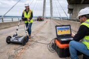
4.9 billion vehicle trips cross US bridges every single day. Most drivers don’t give it a second thought. They probably should. According to the FHWA National Bridge Inve...
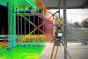
For years, high-resolution reality capture sat at the edge of construction workflows. Laser scanners were accurate but slow, mobile mapping systems were fast but complex,...
In construction, it all starts at ground level—literally. A perfectly poured slab is the first step in building anything from a humble bungalow to a glittering skyscraper...
Topcon Positioning Systems is turning up the heat in road construction tech with a suite of fresh innovations that promise to make paving, scanning, and compaction more e...
Topcon Corporation and FARO Technologies have joined forces in a strategic agreement poised to transform the laser scanning industry. This collaboration is set to push th...
In a world where heritage sites deteriorate by the day, a pioneering neural network offers a powerful tool to bring cultural relics back to their former glory—virtually,...
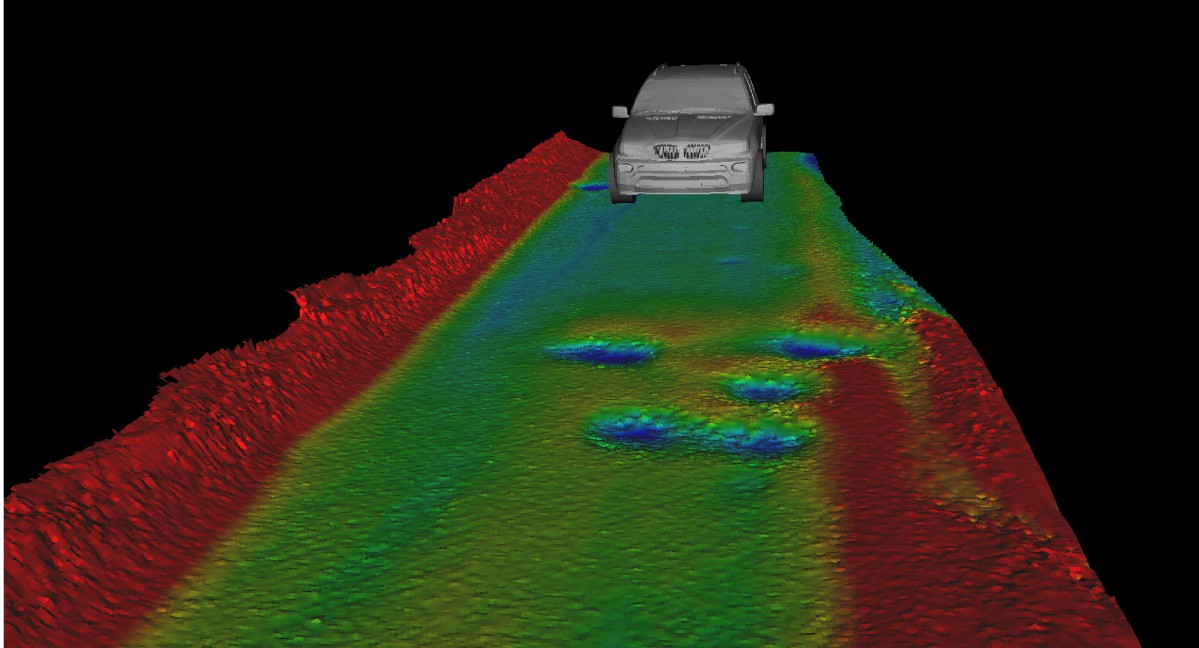
XenomatiX, a developer of true solid state lidar sensors, has added to its road scanning solution the capability to detect with 95% accuracy up to 14 types of road cracks...
PreAct Technologies, an Oregon-based developer of near-field flash LiDAR technology, today announced the availability of its Mojave LiDAR, a high-performance, low-cost se...
PreAct Technologies (PreAct), an Oregon-based developer of near-field flash LiDAR technology, today announced the release of its Mojave LiDAR as a high-performance, low-c...
CAPTURE 3D, a ZEISS company and the leading provider of innovative 3D digitizing solutions in the U.S., today announced the ZEISS ATOS LRX—a new large-volume 3D scanning...
Fugro has been awarded a 6-year contract with the Louisiana Department of Transportation and Development (DOTD) for pavement distress mapping services. The contract is pa...
Anyline, a market leader in mobile data capture, today launched a new capability to scan size and dimension information from the side of any vehicle tire. The scanner can...
EyeVi Technologies, an AI-driven mapping technology start-up, has raised €1.8 million in a seed round led by ff Venture Capital, with the participation of RKKVC, Decacorn...
Topcon Positioning Group has announced its latest scanning robotic total station — the GTL-1200. The GTL-1200 solution combines the power of a robotic total station with...
For navigation and control of any robotic or autonomous outdoor system, GNSS/INS (Inertial Navigation System) is a key component. Inevitably the question arises: should y...
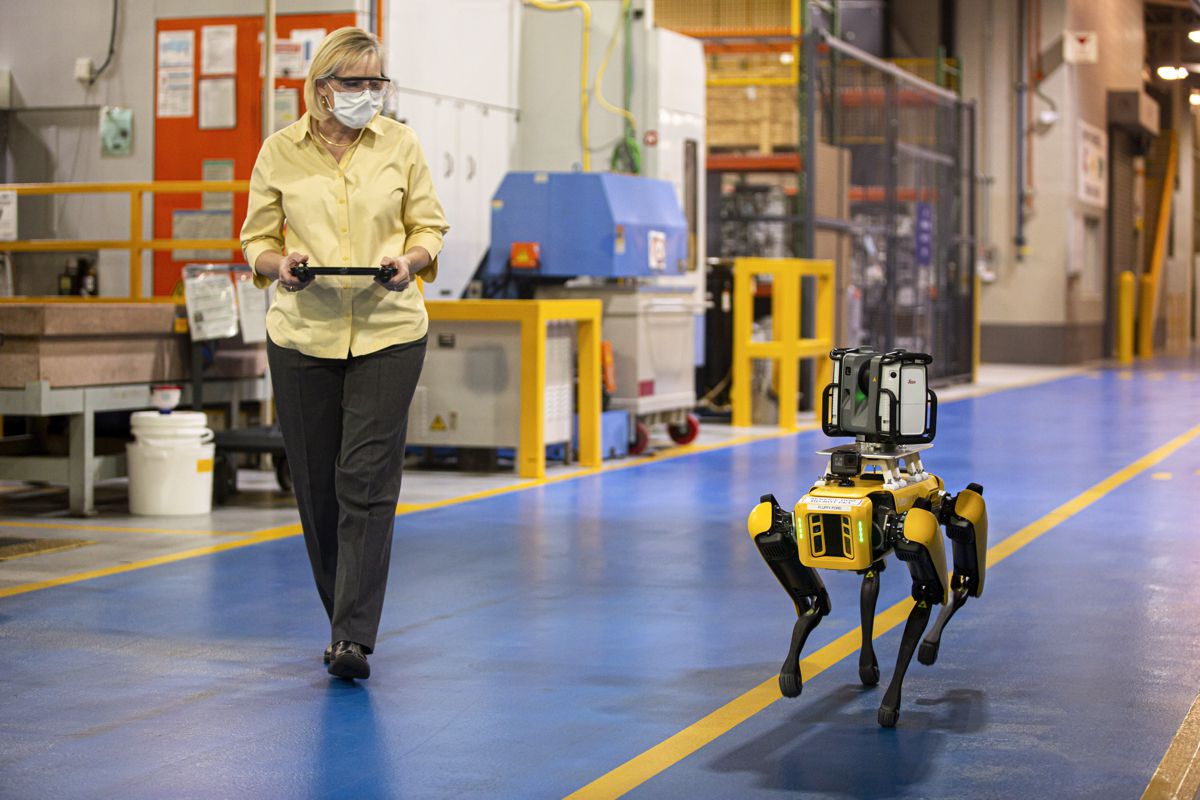
Trimble announced today the release of the Trimble® X7 3D laser scanner and Trimble FieldLink software fully integrated with Boston Dynamics’ Spot® robot. This excl...
Trimble has introduced the Trimble® MX50 mobile mapping system for asset management and mapping — a new addition to its established mobile mapping portfolio. This vehicle...
ACEINNA, one of the world’s leading developers of inertial based guidance and navigation systems for autonomous vehicles and automated machines, today announced that Geos...
Reflective Measurement Systems Ltd has launched the new RetroTek-D vehicle mounted road marking retroreflectometer in Australia and has already secured sales with the Au...
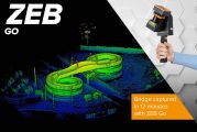
There’s a smarter way to map and understand spaces, and it’s called the ZEB Go. The latest member of the ZEB family has arrived, bringing lower cost simultaneous localiza...
Velodyne Lidar, Inc. today announced that Emesent’s newly introduced Autonomy Level 2 (AL2) technology for Hovermap uses Velodyne lidar sensors to provide real-time perce...
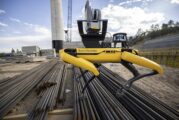
These four-legged dog-like robots can sit, shake hands and roll over. They also can perform 360-degree camera scans, handle 30-degree grades and climb stairs for hours at...
For many years, XenomatiX has been providing road mapping and road scanning services to private sector companies in Belgium, where the company is based as well as around...
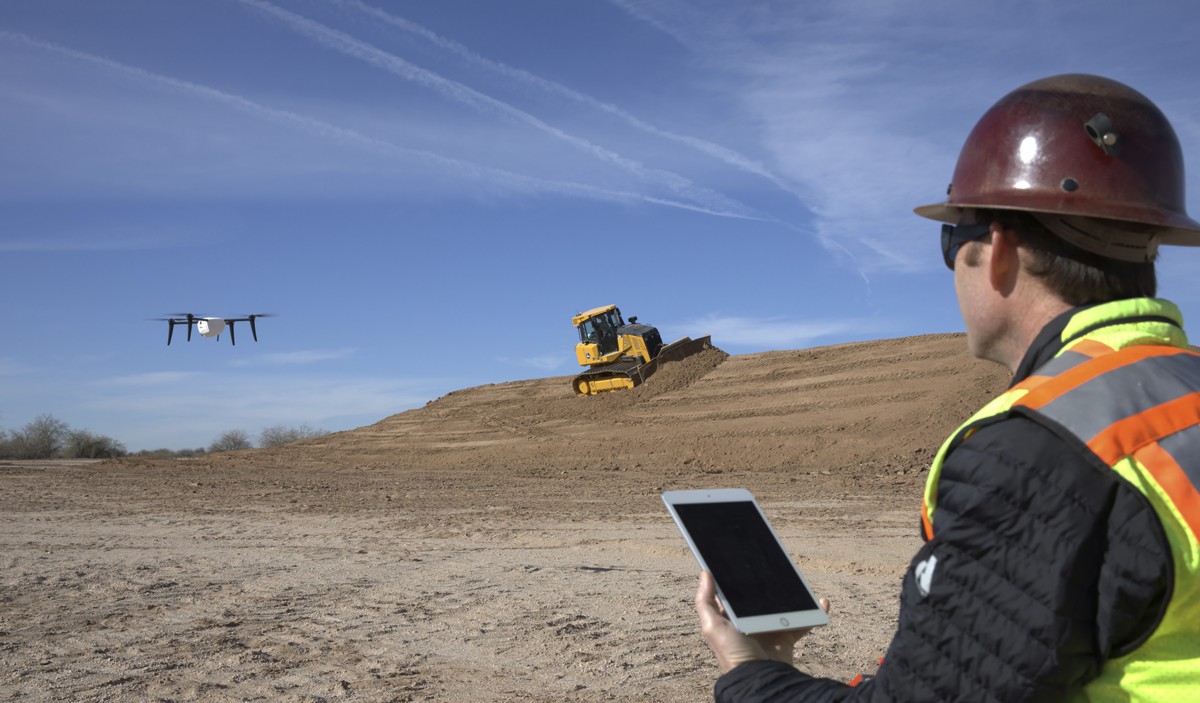
John Deere and Kespry today announced an exclusive global strategic alliance through which John Deere Construction & Forestry dealers will provide the Kespry Aerial I...
This website uses cookies to improve your experience while you navigate through the website. Out of these, the cookies that are categorized as necessary are stored on your browser as they are essential for the working of basic functionalities of the website. We also use third-party cookies that help us analyze and understand how you use this website. These cookies will be stored in your browser only with your consent. You also have the option to opt-out of these cookies. But opting out of some of these cookies may affect your browsing experience.
Necessary cookies are absolutely essential for the website to function properly. These cookies ensure basic functionalities and security features of the website, anonymously.
Cookie
Duration
Description
cookielawinfo-checkbox-analytics
11 months
This cookie is set by GDPR Cookie Consent plugin. The cookie is used to store the user consent for the cookies in the category "Analytics".
cookielawinfo-checkbox-functional
11 months
The cookie is set by GDPR cookie consent to record the user consent for the cookies in the category "Functional".
cookielawinfo-checkbox-necessary
11 months
This cookie is set by GDPR Cookie Consent plugin. The cookies is used to store the user consent for the cookies in the category "Necessary".
cookielawinfo-checkbox-others
11 months
This cookie is set by GDPR Cookie Consent plugin. The cookie is used to store the user consent for the cookies in the category "Other.
cookielawinfo-checkbox-performance
11 months
This cookie is set by GDPR Cookie Consent plugin. The cookie is used to store the user consent for the cookies in the category "Performance".
viewed_cookie_policy
11 months
The cookie is set by the GDPR Cookie Consent plugin and is used to store whether or not user has consented to the use of cookies. It does not store any personal data.
Functional cookies help to perform certain functionalities like sharing the content of the website on social media platforms, collect feedbacks, and other third-party features.
Performance cookies are used to understand and analyze the key performance indexes of the website which helps in delivering a better user experience for the visitors.
Analytical cookies are used to understand how visitors interact with the website. These cookies help provide information on metrics the number of visitors, bounce rate, traffic source, etc.
Advertisement cookies are used to provide visitors with relevant ads and marketing campaigns. These cookies track visitors across websites and collect information to provide customized ads.