Esri and ALERTCalifornia Deliver Real-Time Disaster Monitoring in ArcGIS
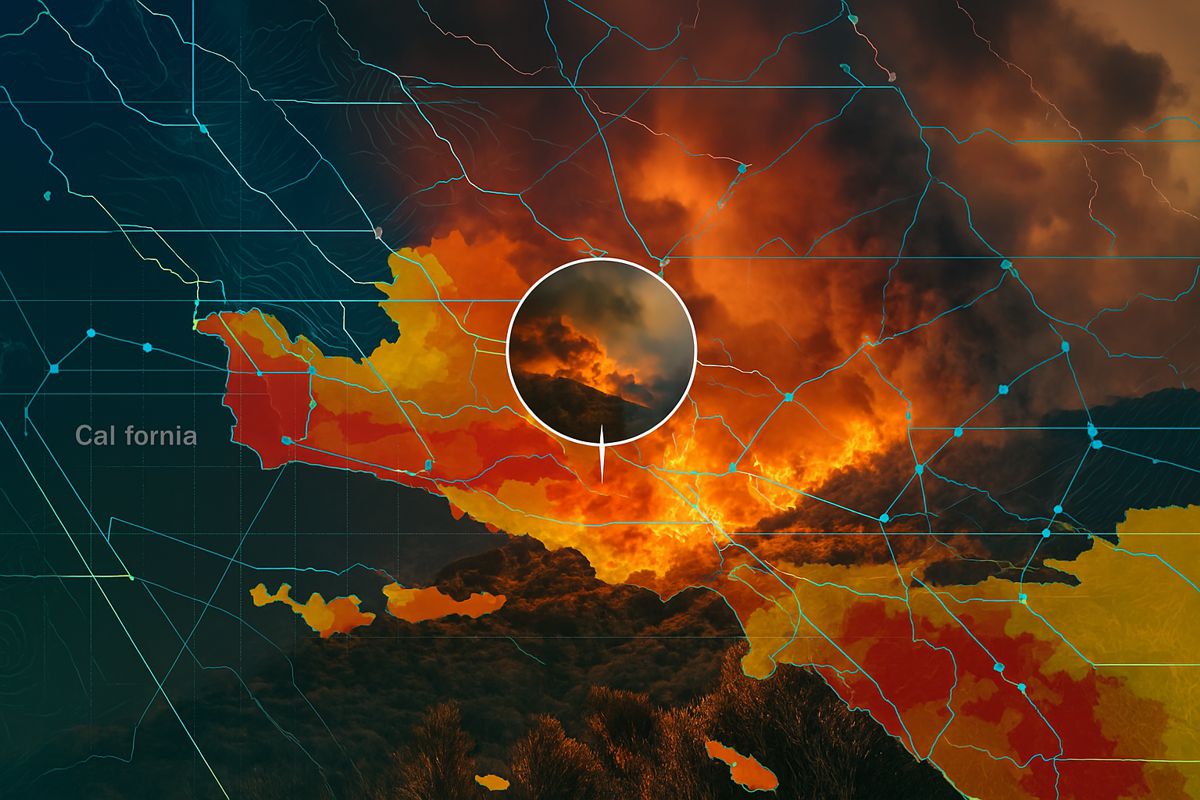
In a bold move to strengthen California’s disaster readiness, Esri has teamed up with the University of California San Diego’s ALERTCalifornia programme to embed more than 1,150 high-definition camera feeds into its ArcGIS Living Atlas.
This cutting-edge integration brings eyes to the frontline of natural disasters, giving emergency responders and the public real-time situational awareness when it matters most.
As the frequency and ferocity of wildfires, floods, and landslides escalate across the state, access to timely and precise data isn’t just helpful—it can be lifesaving. The new map layer offers instant visibility into California’s vast and varied terrain through a constantly updating network of pan-tilt-zoom cameras, providing a significant leap forward in how we prepare for and respond to natural disasters.
What’s in the new ArcGIS layer?
So, what makes this development such a big deal? Here’s what the new ALERTCalifornia camera layer brings to the table:
- Real-time access to over 1,150 cameras with images updating every 15 seconds
- Pan-tilt-zoom functionality offering comprehensive surveillance of wildfire-prone and high-risk areas
- Dynamic viewsheds that reflect topography and terrain features
- Public accessibility via ArcGIS Living Atlas and the ALERTCalifornia.org website
- Customisable integration into ArcGIS dashboards for emergency operations and public safety planning
“The layer significantly enhances emergency responders’ ability to monitor the landscape, detect and track fires, and offers them critical insights that can help save lives and protect communities,” explained Ryan Lanclos, Esri’s Director of Public Safety and National Government Solutions. “Capabilities like this can also be used by the public to help them prepare for an emergency.”
Blending technology and public safety
This collaboration builds on over two decades of wildfire research conducted at UC San Diego. The ALERTCalifornia system doesn’t just rely on visuals—it also harnesses artificial intelligence and environmental sensors to identify smoke, thermal anomalies, and other early indicators of natural hazards.
Neal Driscoll, ALERTCalifornia Director and geoscientist at Scripps Institution of Oceanography, highlighted how critical this data fusion is. “The ALERTCalifornia project provides state-of-the-art sensor technology to support data-driven decisions before, during, and after extreme wildfires,” he said. “These sensors are new tools in the toolbox that allow data to drive firefighting decisions.”
The camera feeds have already proven effective in confirming fire ignition points, informing evacuations, and helping to scale up response resources with unprecedented speed. Whether used by CAL FIRE, local municipalities, or even private landowners, the benefit of instant access to high-quality visuals and environmental readings can’t be overstated.
Seeing the bigger picture—literally
Let’s talk range. These cameras can sweep the horizon in 360 degrees and reach out up to 60 miles during the day and a jaw-dropping 120 miles at night, depending on conditions. That’s a huge advantage when trying to detect a distant smoke plume or track a fast-moving front. Add in topographic data and the viewshed becomes not only broad but highly relevant—tailored to how fire and water actually move across the land.
For Zachary Wells, ALERTCalifornia Deputy Director of Operations and a deputy chief with the Kern County Fire Department, this technology is transforming field operations. “Firefighters in California rely on real-time data to enhance situational awareness and make informed decisions during all-hazard incidents,” he explained. “Integrating ALERTCalifornia data into Esri Living Atlas will increase firefighters’ access to imagery across various applications and platforms they’ve integrated into their daily operations.”
Making data work harder
Beyond raw imagery, the integration into ArcGIS means the data becomes actionable. Emergency managers can pull live feeds into their own digital command centres, layer them with other geospatial data—like wind direction, humidity, or population density—and make informed decisions on the fly.
That’s the power of location intelligence. It’s not just about knowing where something is—it’s about understanding what’s happening there, why it matters, and what to do next.
And it’s not just government agencies that benefit. Infrastructure companies, utility operators, insurers, and even large landowners can tap into this public layer for risk management, operations planning, and post-event analysis.
Esri’s expanding global reach
Founded in 1969 and headquartered in Redlands, California, Esri has grown into a geospatial powerhouse. With operations spanning over 100 countries, its mapping software is used by Fortune 500 firms, local governments, humanitarian agencies, and top-tier universities. This latest development with ALERTCalifornia underscores Esri’s commitment to tackling global challenges with innovative, location-based technology.
From pandemic modelling to flood prediction, from sustainable city planning to climate change mitigation, Esri’s ArcGIS platform is reshaping how data is visualised and used to drive real-world impact.
Looking ahead
The California wildfire season may have become longer and more dangerous, but with initiatives like this, the state is pushing back with smart technology and smarter strategies. The real-time camera feeds now embedded in ArcGIS Living Atlas offer a model for other disaster-prone regions to follow.
Whether you’re a firefighter racing to assess an ignition point, a policymaker evaluating emergency preparedness, or a citizen trying to stay safe in uncertain times, access to reliable, real-time information can make all the difference.
Staying one step ahead
The integration of ALERTCalifornia’s camera network into Esri’s ArcGIS platform isn’t just a tech milestone—it’s a huge win for public safety, environmental protection, and disaster resilience. By making data accessible and actionable, Esri and UC San Diego are arming communities with the tools they need to stay informed and stay safe.
This collaboration shows what’s possible when academia, government, and private industry come together with a common goal: to protect lives, land, and the future.