From Trenches to Digital Twins as Field Reality Capture Enters the Enterprise GIS
Across the global infrastructure sector, the most expensive problems are often the ones nobody can see. Utilities, highways agencies and contractors consistently face delays, redesigns and safety incidents caused by incomplete records of buried assets. Pipes installed decades ago rarely match drawings, and legacy documentation often sits scattered across paper archives, CAD files and fragmented databases. The result is a costly guessing game every time a trench opens.
Industry bodies including the UK’s National Underground Asset Register programme and similar initiatives in North America and Europe have highlighted that inaccurate underground mapping contributes to billions in annual economic losses. Strikes on gas, water and fibre networks not only halt projects but also trigger insurance claims, public disruption and environmental damage. For investors and policymakers, the ability to digitise underground infrastructure has shifted from a technical upgrade to a risk management necessity.
The integration of terrestrial photogrammetry workflows into enterprise geographic information systems represents more than software interoperability. It marks a practical step towards turning physical infrastructure into continuously updated operational data. The collaboration between Esri and Pix4D fits directly into that wider push for verifiable, standardised asset intelligence.
A Direct Path From Field Capture To Enterprise Geospatial Records
Traditionally, collecting accurate as built infrastructure records required survey crews, specialised scanners and lengthy processing cycles. Data might take days or weeks to appear in central systems, long after trenches had been filled. The combined workflow now introduced connects site capture directly into ArcGIS environments, allowing organisations to treat construction progress as live geospatial intelligence rather than retrospective documentation.
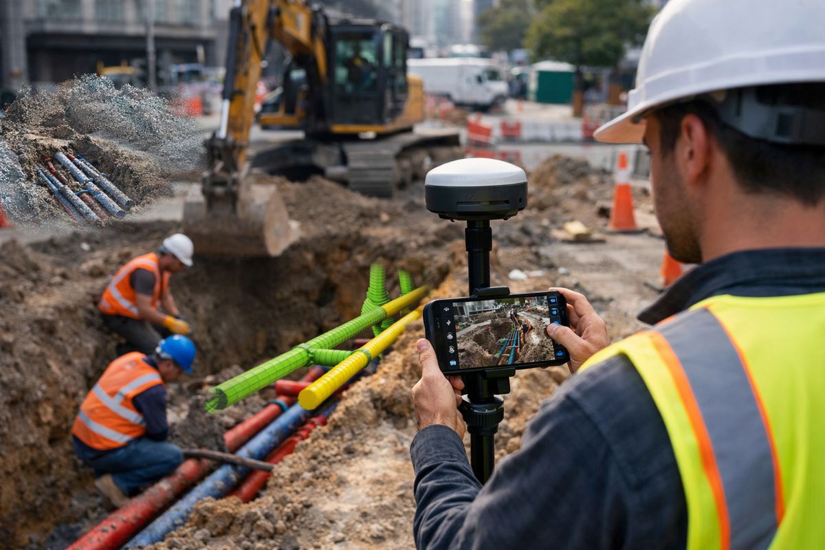
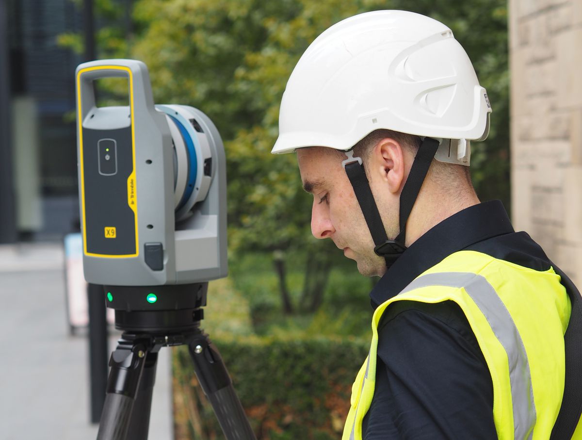
Field teams capture reality using the PIX4Dcatch mobile application paired with real time kinematics positioning devices. The approach effectively transforms handheld devices into survey grade scanners capable of producing georeferenced models. Instead of isolated files, outputs can be published into ArcGIS Online and managed within organisational geodatabases.
This matters operationally because GIS platforms function as the single source of truth across many infrastructure owners. Engineering, maintenance and planning teams already rely on ArcGIS for asset inventories, permitting and network analysis. By feeding reality capture data straight into that environment, the workflow removes a traditional gap between construction activity and operational awareness.
Turning Reality Capture Into Operational Data
Pix4D’s leadership framed the change as a shift in how buried infrastructure is understood: “We are focused on turning hidden infrastructure into functional data,” said Andrey Kleymenov, CEO of Pix4D. “By connecting PIX4Dcatch with a compatible RTK device to the Esri ecosystem, we are enabling a terrestrial-scanning workflow that allows teams to update a master geodatabase with professional accuracy.”
The phrase functional data is important here. Many organisations already possess scans and photographs, yet they remain passive records. A geodatabase, by contrast, supports queries, analytics and lifecycle management. When captured geometry becomes part of a structured dataset, it can drive maintenance planning, permit approvals and future design decisions.
Esri emphasised the same operational continuity: “We are happy to work with Pix4D to offer infrastructure-focused organizations a seamless, direct path from the field into a geodatabase,” said Thomas Fair, Director, Esri Partner Network. “This new integration with ArcGIS will provide users with high-fidelity documentation of subsurface assets.”
In practice, that seamless path reduces manual transcription and interpretation. Surveyors no longer need to redraw pipes from sketches. Engineers no longer rely solely on contractor reports. The captured geometry itself becomes the record.
As Designed Versus As Built Becomes Immediate Verification
One of the most commercially significant aspects of the workflow lies in augmented reality verification before trenches are closed. Historically, discrepancies between design and installation often surfaced months later during commissioning or maintenance. Rectifying those issues required excavation, contract disputes and redesign.
The ability to overlay captured scans against design data on site changes the sequence entirely. Contractors can confirm alignment, depth and placement in real time. If a duct is misplaced by a few centimetres, it can be corrected immediately while equipment remains on site.
For project owners, this alters risk allocation. Verification shifts from post construction validation to construction stage quality assurance. Claims related to unknown conditions or installation inaccuracies become easier to evaluate because the digital record reflects what physically existed at closure.
This type of verification also aligns with broader digital twin initiatives. A twin cannot function without reliable baseline geometry. By embedding validated subsurface models into enterprise GIS, organisations effectively build the foundation of a continuously updated twin rather than a static snapshot.
The Growing Importance Of Mobile Mapping In Infrastructure Delivery
The emergence of handheld capture workflows reflects a wider trend across surveying and construction technology. Mobile LiDAR, photogrammetry and simultaneous localisation and mapping techniques have steadily reduced the cost and complexity of reality capture. What once required specialist survey equipment can now be performed by trained site staff.
From a productivity standpoint, this democratisation is significant. Infrastructure projects frequently operate under tight possession windows or traffic management constraints. Waiting for specialist crews can delay progress. Allowing field teams to capture accurate records as part of standard workflow reduces both downtime and mobilisation costs.
Furthermore, mobile capture supports regulatory compliance. Many jurisdictions increasingly require accurate asset recording, particularly for utilities and transport corridors. Digital submissions derived directly from georeferenced scans simplify handover processes and reduce disputes between contractors and asset owners.
Enterprise GIS As The Backbone Of Infrastructure Intelligence
ArcGIS platforms already underpin planning, environmental assessment and network operations for governments and private operators worldwide. Integrating reality capture directly into that ecosystem strengthens GIS as an operational backbone rather than a planning tool.
Once incorporated into a Scene Layer, 3D point clouds and models become accessible to multiple departments. Maintenance teams can inspect buried structures virtually before excavation. Planners can evaluate capacity constraints. Emergency responders can understand underground risks during incidents.
The broader significance lies in standardisation. Infrastructure organisations typically run complex technology stacks including BIM, asset management and document control systems. GIS often acts as the spatial index connecting them. By publishing high precision capture data into GIS first, organisations ensure every downstream system references the same verified geometry.
Implications For Contractors And Asset Owners
For contractors, the workflow provides defensible documentation. Payment milestones, change orders and warranty discussions increasingly rely on evidence rather than narrative reports. A georeferenced model showing exact installation conditions reduces ambiguity in contractual negotiations.
For asset owners, lifecycle management improves. Underground networks last decades, often outliving the original project teams. Capturing accurate spatial records at installation avoids costly rediscovery efforts during upgrades or repairs. Over time, the accumulated dataset forms a comprehensive infrastructure knowledge base.
Financially, the implications extend to insurance and financing. Lenders and insurers assess risk partly based on documentation quality. Projects with verifiable digital records demonstrate stronger asset governance, which can influence financing terms and long term operational costs.
A Practical Step Toward Data Driven Infrastructure
The collaboration between Esri and Pix4D does not introduce a single breakthrough technology. Photogrammetry, RTK positioning and GIS platforms already exist independently. The value lies in stitching them into a coherent workflow that matches how construction actually operates.
Infrastructure digitalisation often falters because processes remain fragmented. Data captured on site must be converted, uploaded and interpreted before it becomes useful. Each step introduces delay and potential error. A direct pipeline from capture to geodatabase removes friction and encourages adoption.
As infrastructure programmes accelerate worldwide, particularly with climate resilience and urban expansion initiatives, organisations increasingly prioritise accurate asset intelligence. Knowing what exists underground becomes as important as designing what goes above it. Workflows that make that knowledge immediate rather than retrospective will shape future project standards.
The integration therefore represents a shift in expectation. Recording reality is no longer documentation at the end of construction. It becomes a continuous operational activity embedded in daily site work. In that sense, the trench stops being a temporary excavation and becomes the moment where physical infrastructure enters its digital lifecycle.