


Sanborn Map Company unveils Enhanced Image Analyst Application The Sanborn Map Company has unveiled an en ...
-
Sanborn Map Company unveils Enhanced Image Analyst Application
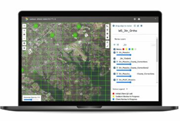
Sanborn Map Company unveils Enhanced Image Analyst Application
-
MIT creating Agricultural Maps with AI and Satellite Data

MIT creating Agricultural Maps with AI and Satellite Data
-
Maxar Intelligence wins Precision3D Data contract from NGA

Maxar Intelligence wins Precision3D Data contract from NGA
-
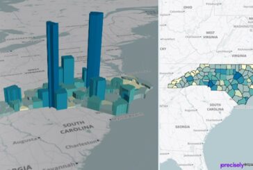
Large-scale Urban Building Function Mapping using web-based Geospatial Data

Large-scale Urban Building Function Mapping using web-based Geospatial Data
-
ArcGIS upgrades help to efficiently and securely build solutions

ArcGIS upgrades help to efficiently and securely build solutions
-
SketchUp now available on Meta Quest VR Headsets

SketchUp now available on Meta Quest VR Headsets
-
National Geographic MapMaker launched by Esri and National Geographic Society

National Geographic MapMaker launched by Esri and National Geographic Society
-
Esri now integrates with Microsoft Fabric adding Spatial Analytics

Esri now integrates with Microsoft Fabric adding Spatial Analytics
-
Esri ArcGIS Basemaps and ArcGIS Living Atlas to be integrated with Autodesk

Esri ArcGIS Basemaps and ArcGIS Living Atlas to be integrated with Autodesk
-
Felt 2.0 hailed as the most powerful tool for Professional Map Making
Felt 2.0 hailed as the most powerful tool for Professional Map Making
-
National Highways wins Esri Special Achievement in GIS Award

National Highways wins Esri Special Achievement in GIS Award
-
Esri enhances 3D GIS Workflows by integrating 3D Tiles into ArcGIS

Esri enhances 3D GIS Workflows by integrating 3D Tiles into ArcGIS
-
Delhi Metro uses Digital Modelling to add 62km of Railway

Delhi Metro uses Digital Modelling to add 62km of Railway
-
VertiGIS Networks web-based Utility Network Management rolled out globally
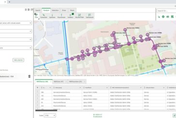
VertiGIS Networks web-based Utility Network Management rolled out globally
-
MapInfo Pro strengthens its Spatial Analytics and Mapping Visualisation
MapInfo Pro strengthens its Spatial Analytics and Mapping Visualisation
-
VertiGIS acquires Location-Intelligence company ibR

VertiGIS acquires Location-Intelligence company ibR
-
Topcon acquires Pennsylvania-based Boyd Instrument and Supply

Topcon acquires Pennsylvania-based Boyd Instrument and Supply
-
Winners of the Esri 2023 ArcGIS Online Competition announced

Winners of the Esri 2023 ArcGIS Online Competition announced
-
New book explores Designing Map Interfaces to build effective Map Apps

New book explores Designing Map Interfaces to build effective Map Apps
-
Wejo and 60-member University Consortium to advance GIS Research

Wejo and 60-member University Consortium to advance GIS Research