


Revolutionized approach to Mapping is essential and unavoidable The purpose of mapping has been to help p ...
-
Revolutionized approach to Mapping is essential and unavoidable

Revolutionized approach to Mapping is essential and unavoidable
-
Esri to provide Malta with GIS Technology and Training

Esri to provide Malta with GIS Technology and Training
-
Esri joins Overture Maps Foundation to build Interoperable Open Map Data

Esri joins Overture Maps Foundation to build Interoperable Open Map Data
-
Czech Railway to use Ness Digital Maps built on Hexagon technology

Czech Railway to use Ness Digital Maps built on Hexagon technology
-
GIS data solutions for the Nevada Department of Transportation
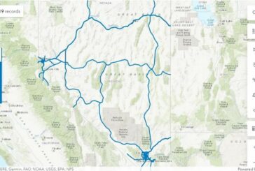
GIS data solutions for the Nevada Department of Transportation
-
Esri and Digital Earth Africa partner to support Sustainable Growth

Esri and Digital Earth Africa partner to support Sustainable Growth
-
Otonomo to help Geograma advance Road Safety in Spain

Otonomo to help Geograma advance Road Safety in Spain
-
Nextech AR adopts LiDAR for real-world Metaverse Spatial Mapping
Nextech AR adopts LiDAR for real-world Metaverse Spatial Mapping
-
Esri initiative offers free Geospatial Software to Non-profits

Esri initiative offers free Geospatial Software to Non-profits
-
Esri releases latest edition of Online GIS Capabilities book

Esri releases latest edition of Online GIS Capabilities book
-
BlackSky partners with Esri for Dynamic Satellite Tasking for ArcGIS

BlackSky partners with Esri for Dynamic Satellite Tasking for ArcGIS
-
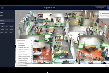
Esri launches Indoor Positioning Navigation System

Esri launches Indoor Positioning Navigation System
-
Wejo extends and expands relationship with Microsoft Maps

Wejo extends and expands relationship with Microsoft Maps
-
Geo Connect Asia celebrates successful 2022 event

Geo Connect Asia celebrates successful 2022 event
-
Geo Connect Asia returns with more exhibitors, larger audience and eased restrictions

Geo Connect Asia returns with more exhibitors, larger audience and eased restrictions
-
Aeva 4D LiDAR Technology helping NASA to Map the Moon

Aeva 4D LiDAR Technology helping NASA to Map the Moon
-
Esri StoryMaps brings sophisticated Mapping Technology to Storytelling

Esri StoryMaps brings sophisticated Mapping Technology to Storytelling
-
Esri UK annual GIS conference returns to QEII Centre in London

Esri UK annual GIS conference returns to QEII Centre in London
-
GeoPlace 2022 Conference aims to Connect People with Places

GeoPlace 2022 Conference aims to Connect People with Places
-
ArcGIS Image for ArcGIS Online to enhance City Services in Yakima, Washington

ArcGIS Image for ArcGIS Online to enhance City Services in Yakima, Washington