


Topcon celebrates Great Place to Work award for USA, Spain and Netherlands Topcon Positioning Systems has ...
-
Topcon celebrates Great Place to Work award for USA, Spain and Netherlands

Topcon celebrates Great Place to Work award for USA, Spain and Netherlands
-
Trimble to showcase Surveying Solutions at DCW and GeoBusiness

Trimble to showcase Surveying Solutions at DCW and GeoBusiness
-
Topcon to build State-Of-The-Art Manufacturing Facility in Germany
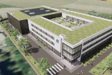
Topcon to build State-Of-The-Art Manufacturing Facility in Germany
-
Smart Construction to champion Digitalisation at Intermat 2024 with Edge 2

Smart Construction to champion Digitalisation at Intermat 2024 with Edge 2
-
Civ Robotics teams up with Point One Navigation for high-tech Land Surveying
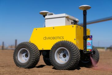
Civ Robotics teams up with Point One Navigation for high-tech Land Surveying
-
Trimble unveils cutting-edge Construction Technology Solutions
Trimble unveils cutting-edge Construction Technology Solutions
-
Banks Engineering in Florida acquired by Atwell

Banks Engineering in Florida acquired by Atwell
-
The AVIID Dataset is a revolution in Aerial Imaging

The AVIID Dataset is a revolution in Aerial Imaging
-
Topcon expands layout portfolio with LN-50 3D Laser
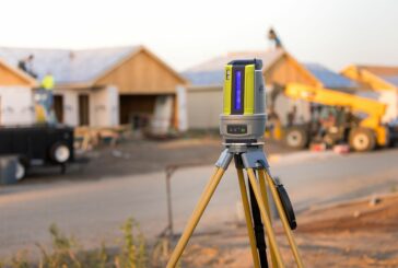
Topcon expands layout portfolio with LN-50 3D Laser
-
Skydio and Trimble evolve precision Surveying with Drone Tech

Skydio and Trimble evolve precision Surveying with Drone Tech
-
HP SitePrint Robot now available in North America, UK and Ireland
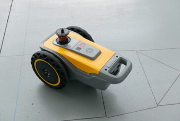
HP SitePrint Robot now available in North America, UK and Ireland
-
ModalAI announces Smaller, Smarter and Safer Development Drone
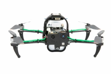
ModalAI announces Smaller, Smarter and Safer Development Drone
-
Transforming Unmanned Navigation and Robotics Integration with GNSS/INS Sensors
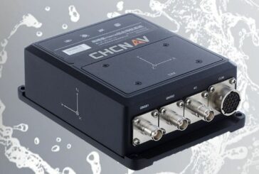
Transforming Unmanned Navigation and Robotics Integration with GNSS/INS Sensors
-
Revolutionising Underwater Surveying, Mapping and Inspection

Revolutionising Underwater Surveying, Mapping and Inspection
-
Meet the FIFISH V-EVO Underwater Drone

Meet the FIFISH V-EVO Underwater Drone
-
Exyn Technologies and Trimble show off Autonomous Surveying concept
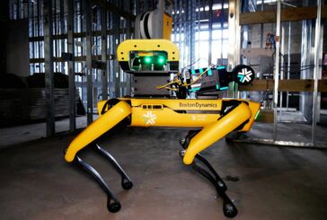
Exyn Technologies and Trimble show off Autonomous Surveying concept
-
Topcon to feature latest Construction Surveying and Geopositioning tech at bauma
Topcon to feature latest Construction Surveying and Geopositioning tech at bauma
-
Teledyne FLIR to debut industrial inspection SIRAS Drone
Teledyne FLIR to debut industrial inspection SIRAS Drone
-
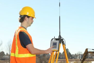
Trimble announces rugged, lightweight Field Data Controller for Surveying
Trimble announces rugged, lightweight Field Data Controller for Surveying
-
SCCS and Senceive distribute Leica surveying and wireless monitoring products to the UK

SCCS and Senceive distribute Leica surveying and wireless monitoring products to the UK