Seequent Brings AI Geological Analysis to Drill Core Photography
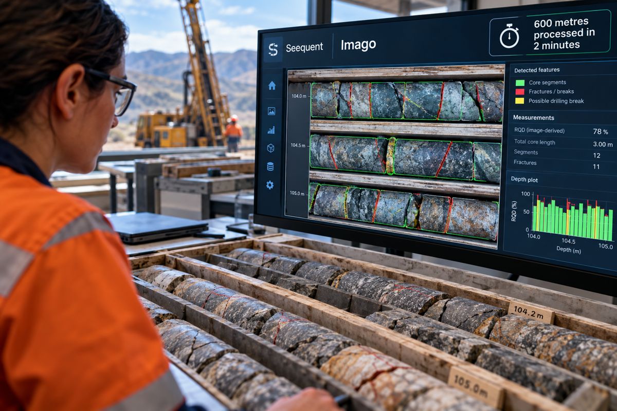
Six hundred metres of drill core photography, analysed in two minutes. That is the processing speed Seequent reports for its new AI-powered Imago image analysis system, which converts photographs of recovered rock into structured geological datasets ready for further interpretation.
The technology addresses a familiar problem in mineral exploration. Drilling programmes generate extensive photographic records of the rock recovered from beneath the surface, but extracting measurements from those images has traditionally required considerable manual work. Historical archives can contain years of potentially useful geological information, much of it recorded under different logging procedures or never analysed systematically.
Seequent, Bentley Systems‘ subsurface software business, has introduced the capability as an add-on to its cloud-based Imago platform. Using purpose-built machine-learning models, the software prepares and analyses drill core photographs, producing depth-referenced measurements that geologists can review before incorporating them into exploration databases and three-dimensional geological models.
The company says the technology can process both newly acquired imagery and photographs collected during earlier drilling campaigns, allowing exploration teams to revisit existing geological records without returning to the field.
Briefing
- Seequent has launched Imago image analysis, an AI-powered add-on to its geological imagery platform.
- The software converts drill core photographs into quantitative, depth-referenced geological datasets.
- In a company-reported example, imagery covering 600 metres of drill core was processed in two minutes.
- Outputs include measurements supporting Rock Quality Designation (RQD) assessment and geological interpretation.
- Validated results can be transferred into Leapfrog and MX Deposit, while geologists retain responsibility for reviewing the analysis.
From Core Images to Geological Data
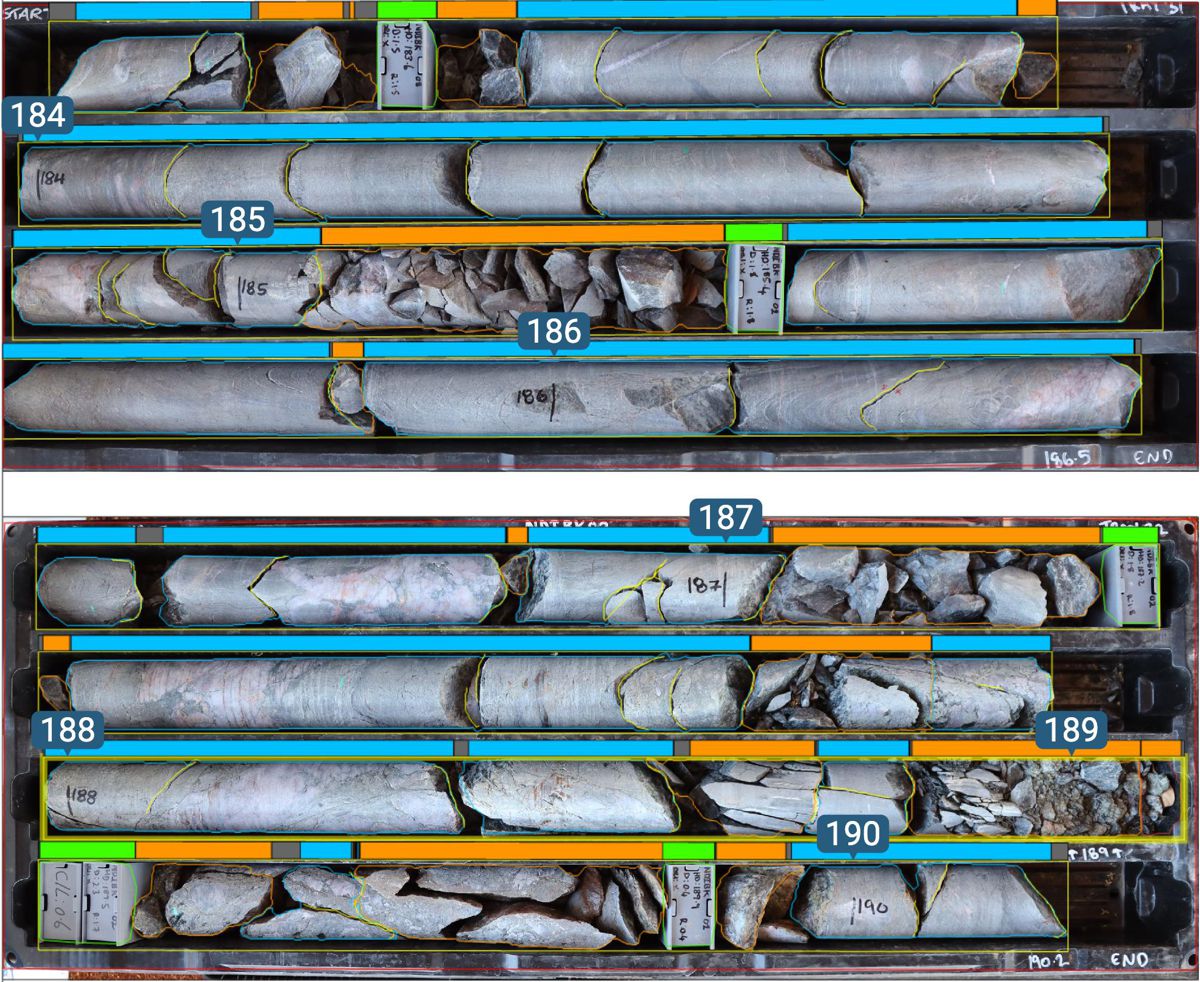
Drill core provides direct physical evidence of the geological formations encountered beneath the surface. As drilling progresses, cylindrical sections of rock are recovered, arranged in trays, photographed and logged to record their geological and structural characteristics.
These photographs are valuable records, particularly when the physical core is subsequently transferred into long-term storage or becomes difficult to access. Yet extracting consistent measurements from thousands of images can be demanding, especially when drilling programmes extend across multiple deposits, contractors and years.
Imago image analysis applies machine-learning models to the photographs, identifying measurable characteristics and converting them into structured information associated with the relevant drillhole depths. Among the outputs identified by Seequent are datasets supporting Rock Quality Designation, a widely used measure of rock mass quality.
RQD is conventionally calculated as the percentage of a core run represented by qualifying pieces of sound rock longer than 100 mm. The measurement is used in established rock mass classification systems and contributes to assessments of geological conditions in mining, tunnelling and underground construction.
Determining RQD from photographs introduces particular challenges. Visible breaks in recovered core do not necessarily correspond to natural fractures within the rock mass. Some may have occurred during drilling, extraction or handling, while other discontinuities may be obscured by the arrangement of the core or the quality of the photograph.
Automated image measurements therefore require geological review before they can be accepted as reliable representations of the recovered rock. Seequent has retained that step within Imago, allowing geologists to examine the generated measurements alongside the original imagery, adjust the analysis and validate the results.
The distinction between image processing and geological interpretation is important. Although the company reports processing 600 metres of imagery in two minutes, that figure does not establish how long a complete, professionally validated geological assessment would take. Seequent has not published independent accuracy benchmarks demonstrating performance across different rock types, fracture conditions and photographic standards.
Unlocking Historical Drill Core Archives
For exploration companies with long-established drilling programmes, the ability to analyse historical imagery may prove as useful as accelerating the processing of new photographs.
Mineral projects frequently pass through successive exploration campaigns, ownership changes and periods of inactivity. Their geological records can include extensive collections of core photography, sometimes accumulated over decades and accompanied by varying levels of interpretation.
Earlier campaigns may have used different logging conventions, while some photographs may contain geological details that were not systematically measured when the core was first examined. Revisiting those records has traditionally involved substantial manual work, particularly when original core is stored remotely or is no longer readily accessible.
Imago image analysis offers a way to apply a more consistent measurement process across existing image libraries. Rather than examining each tray photograph individually to extract selected measurements, geological teams can generate datasets for subsequent review and comparison with historical logging records.
The quality of the original photography remains a practical constraint. Lighting, resolution, tray layout and the completeness of depth information all influence what can be extracted reliably. Older image collections may require preparation or correction before automated analysis can produce useful results.
Nevertheless, the prospect of recovering additional information from drilling expenditure already incurred is commercially attractive. Exploration programmes can involve substantial investment in mobilisation, drilling, sampling and geological supervision. The resulting photographic archive may retain value long after the original campaign has finished.
For projects undergoing renewed exploration or geological reassessment, reprocessing those images could help identify intervals that warrant closer examination, support comparisons between drilling campaigns or provide additional measurements for geological models.
It cannot replace physical sampling or laboratory analysis where those are required, but it may allow existing information to be examined more thoroughly before decisions are made about further drilling.
Connecting Analysis with Geological Models
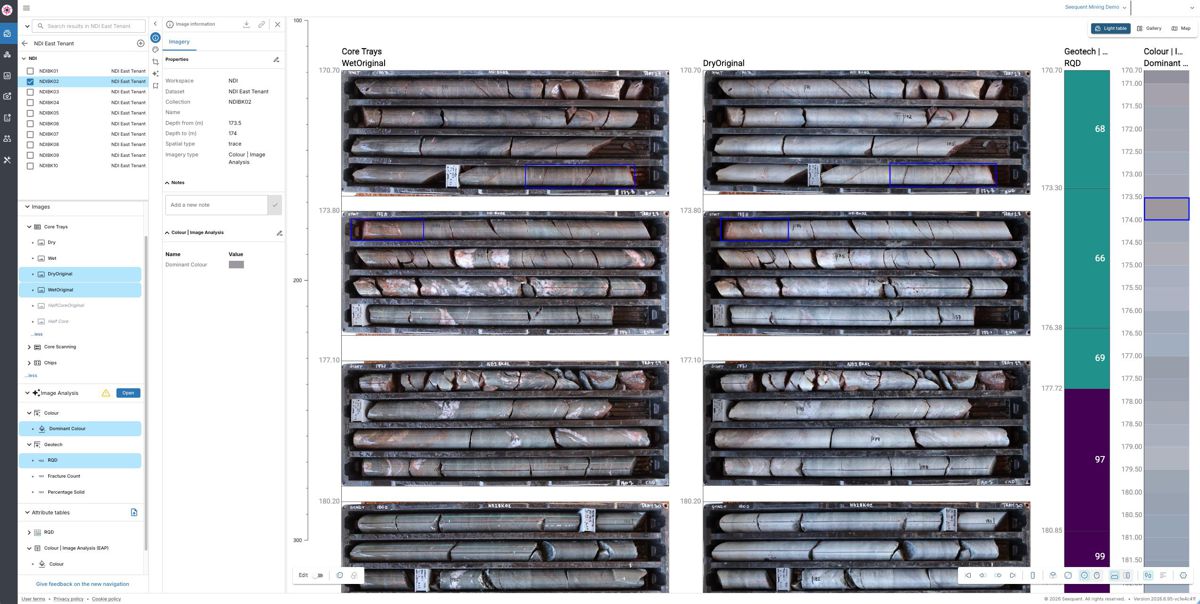
Seequent has built the new capability into its existing Imago environment rather than introducing a separate image-processing application. Photographs and the measurements generated from them remain connected, allowing geologists to move between the visual evidence and the corresponding analytical results.
Once validated, interval data can be transferred into Leapfrog for three-dimensional geological modelling and MX Deposit for drillhole and sample data management. The company also supports connections with other geological software used in exploration workflows.
That integration reduces the need to manually transfer measurements between disconnected systems, a process that can introduce transcription errors or make it difficult to trace interpreted data back to its original source.
Geologists working with complex deposits often need to revisit earlier interpretations as new drilling results become available. Maintaining a connection between the original core imagery and the information incorporated into a geological model allows unusual measurements to be investigated and earlier assumptions reconsidered.
Tim Schurr, Seequent’s Product Line Manager, Drilling Data, said: “Every core tray represents a substantial investment, yet core logging has traditionally been a manual, qualitative process, with results influenced by the training, experience, time and resources available to the geologist or core logger.
“By applying AI within Imago’s established workflow, Imago image analysis brings repeatability to the process, helping organisations save time and money while improving the consistency of the data captured. That matters for every decision that follows. Geologists can investigate unexpected results, challenge assumptions and validate and strengthen the models that guide drilling decisions.”
The approach places automated measurement within an established geological workflow, where the outputs can be checked against the original photographs and considered alongside other geological evidence.
That remains necessary even where image measurements are repeatable. Consistency does not, by itself, establish geological accuracy, and measurements extracted from photographs must still be interpreted in the context of drilling conditions, core recovery and the characteristics of the surrounding rock mass.
Applications in Infrastructure Engineering
Although Seequent is introducing Imago image analysis primarily for mineral exploration, the underlying approach has potential applications in civil engineering ground investigations.
Rock core photography is routinely used during investigations for tunnels, dam foundations, underground excavations, transport corridors and other infrastructure where geological conditions influence design and construction.
Borehole investigations generate records of core recovery, fracture frequency, rock quality and geological structure. These measurements contribute to geotechnical assessments alongside laboratory testing, field mapping, borehole observations and other investigation data.
Large infrastructure programmes can involve numerous boreholes drilled over several investigation phases, sometimes years apart. Their photographic records may be produced by different contractors and subsequently incorporated into a common ground model.
Consistent image-based measurements could help engineering geologists review those records and compare selected characteristics across investigation campaigns. The ability to return from an interpreted measurement to the original core photograph would also be useful when geological assumptions are revisited during design or construction.
However, the announcement does not establish that Imago image analysis has been specifically validated for civil engineering design or compliance with geotechnical investigation standards.
Rock mass assessments require information that cannot necessarily be recovered from conventional core tray photography. Discontinuity orientation, intact rock strength, groundwater conditions and in-situ behaviour may require additional investigation, measurement or testing.
The overlap between mining exploration and infrastructure ground investigation is nevertheless substantial. Both disciplines depend on reliable geological records, and both face the practical challenge of managing large volumes of subsurface information collected over extended periods.
Accuracy, Data Management and Commercial Adoption
The introduction of automated geological analysis raises questions about measurement accuracy, information governance and the level of professional review required before results can be used in consequential decisions.
Seequent states that customer imagery and geological data remain managed within the Imago environment, with customers retaining control over their information. Customers can also choose whether their data is used to improve analysis outcomes.
For exploration companies, these arrangements warrant attention because drilling records can contain commercially sensitive information about mineral deposits, exploration targets and undeveloped resources. The announcement does not detail every aspect of data residency, model training or contractual information controls, which would need to be established during procurement.
The reliability of the analytical outputs is equally important. Measurements contributing to mineral resource estimates, mine planning or engineering assessments need to be traceable to their underlying evidence and reviewed in accordance with the relevant professional and project requirements.
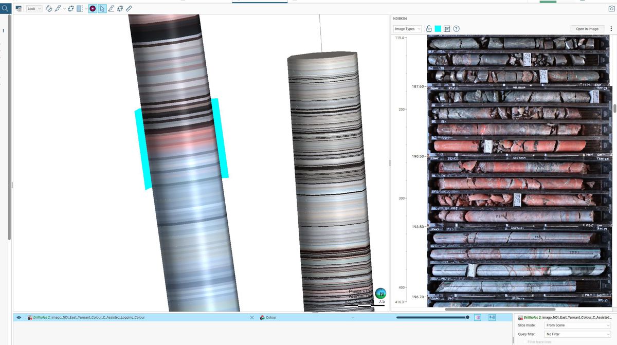
Imago’s connection between source photographs and generated measurements provides a basis for that review, although the announcement does not establish the full extent of the system’s audit-trail and version-control capabilities.
There is also the question of cost. Seequent has not disclosed pricing for the new add-on or published independently verified estimates of the labour savings achievable through automated processing.
Those savings will vary according to the volume and quality of available imagery, the measurements being extracted and the amount of manual intervention still needed. Organisations with extensive historical archives or regular drilling programmes may have different requirements from smaller exploration companies undertaking occasional investigations.
The reported ability to process 600 metres of core imagery in two minutes provides an indication of the system’s computational performance. Whether that translates into faster geological decisions will depend on the quality of the resulting measurements and the work required to validate them.
For geological teams already using Imago, Leapfrog and MX Deposit, the new capability offers a relatively direct route from core photography into established exploration workflows. It also creates an opportunity to revisit photographic records that may have remained largely untouched since the original drilling campaigns.
The photographs themselves have not changed. What is changing is the speed at which their measurable characteristics can be extracted, compared and incorporated into geological interpretation.
Key Industry Questions
- What is Seequent Imago image analysis? It is an AI-powered add-on to Seequent’s Imago platform that processes drill core photographs and generates structured, depth-referenced geological measurements for professional review.
- How quickly can Imago analyse drill core imagery? Seequent reports processing imagery covering 600 metres of drill core in two minutes. This is a company-reported processing example, not a benchmark for completing a validated geological interpretation.
- Can AI calculate Rock Quality Designation from photographs? Image analysis can support RQD assessment by identifying and measuring visible core segments. Geologists must still account for drilling-induced breaks, disturbed core and other factors affecting the interpretation.
- Can historical drill core photographs be analysed? Yes. The system is designed to work with new and archived imagery, provided the photographs and associated depth information are suitable for analysis.
- Does Imago image analysis replace geological logging? No. It automates selected image preparation and measurement tasks. Geological interpretation, validation and decisions requiring professional judgement remain the responsibility of qualified personnel.
- Which geological software applications can use the results? Validated interval data can be transferred into Seequent’s Leapfrog geological modelling software and MX Deposit drillhole and sample data management platform, as well as other integrated applications.
- Could the technology be used for infrastructure ground investigations? The underlying image analysis methods have potential relevance to geotechnical core logging, although Seequent has not announced specific validation for civil engineering design applications.
- How is customer geological data managed? Seequent states that customers retain control of their imagery and geological data within Imago. Customers can optionally allow their information to contribute to improved analysis outcomes, subject to the applicable arrangements.
Strategic Takeaways
- Automated analysis could extend the useful life of historical drilling records by extracting measurements that were not systematically captured during the original exploration campaigns.
- Repeatable image measurements may improve consistency across drilling programmes, provided photographic quality and geological validation are maintained.
- Direct integration with geological databases and modelling software reduces the need to transfer analytical results between separate applications.
- Image-derived rock quality measurements require professional interpretation, particularly where drilling-induced fractures or disturbed core affect the photographic evidence.
- Commercial adoption will depend on demonstrated accuracy, the volume of imagery available for processing, software costs and the amount of manual review still required.