


XenomatiX technology delivers a new era of affordable road inspections
XenomatiX has developed an innovative and affordable solution for performant and cost-effective road management, taking advantage of the latest sensor technologies of solid state lidar.
Road authorities are tasked with keeping roads in good shape and must guarantee adequate levels of safety on the road. This is usually achieved by monitoring the degradation of road conditions, which manifests itself with growing presence of cracks, potholes and pavement distresses.
Traditionally methods use lasers or cameras, which are both expensive and labour intensive. A more desirable solution is to have a low-cost system that can monitor roads with minimal human intervention.
The XenomatiX solution is based on ‘6d road scanning’ that can detect and analyse any type of distress on the road surface, such as cracks, potholes, waviness, rutting etc.
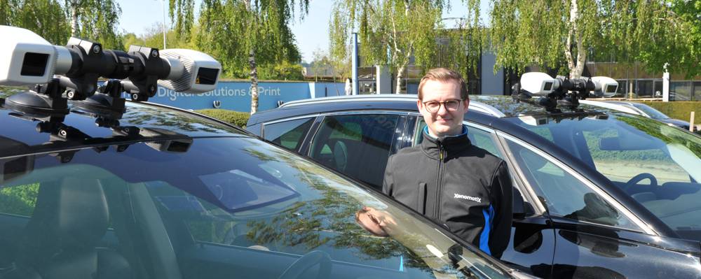
XenomatiX Road Scanning lidar sensors are mounted on top of a regular vehicle and digitize the road surface, collecting 3D point clouds, surface reflectivity data and 2D camera images in a total of six dimensions, all annotated with detailed GPS data. These measurements can be delivered as raw data or can be analysed by XenomatiX road engineering experts.
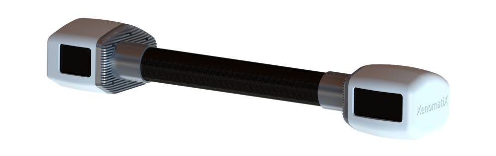
XenoTrack is a car-mountable, high precision, high-resolution, short-range solid-state lidar sensor with accuracy to within a millimetre. Capable of identifying road waviness, road damage, small and nearly invisible objects in real-time or post-processing.
- 3D point clouds, surface reflectivity data, and camera images, can all be collected at highway speed, and all of the resulting data is annotated with detailed GPS data.
Currently, the sensor is available in two versions:
- XenoTrack RearView – Offers detailed surface measurements accurate to within 1mm, making it ideal for applications such as pothole detection, surface monitoring during road construction works, seasonal surface degradation analysis, road waviness, etc.
- XenoTrack FrontView – Designed for real-time application relying on preview measurements such as active suspension for ultimate driving comfort, lane keeping, small but dangerous road obstacle avoidance, and more.
Additionally, XenoTrack’s software, XenoWare, offers an intuitive framework to integrate XenoTrack into any real-time or offline road profile applications. With built-in stitching and mapping algorithms, XenoWare easily reconstructs the surface for an in-depth examination.
In the near future, XenomatiX expects to see these sensors mounted on dedicated and utility vehicles, providing weekly measurements. In the next 10 years, the company believes that with higher levels of autonomous vehicles, this technology will be implemented in many future cars and data will be collected by all road users.
“In the future, a lot of data can be collected without specific vehicles and resources,” De Meester said, XenomatiX VP of Sales and Business Development. “For example, a community garbage truck gets road lidar. In the next week, another truck driving through a different part of the community gets one, and so on. After a month or two, the whole community is digitized. If you can do that regularly, you can really see what the degradation is. That’s how we see it is going to help the pavement management system.”
Today, XenomatiX offers to its customers road dataset off-the-shelf. This is collected and partially analysed data measurements of pavement conditions, road markings, and road damages, available for different road profiles, including cobblestone, concrete plates, gravel, tunnel, and bridge.
All data sets are available in different formats, such as 3D geometrical data in CSV, CRG, and 2D images, or reflectivity data in PGM.
Today these datasets are used by road authorities as well as academics for simulation tests, or proprietary software development.


