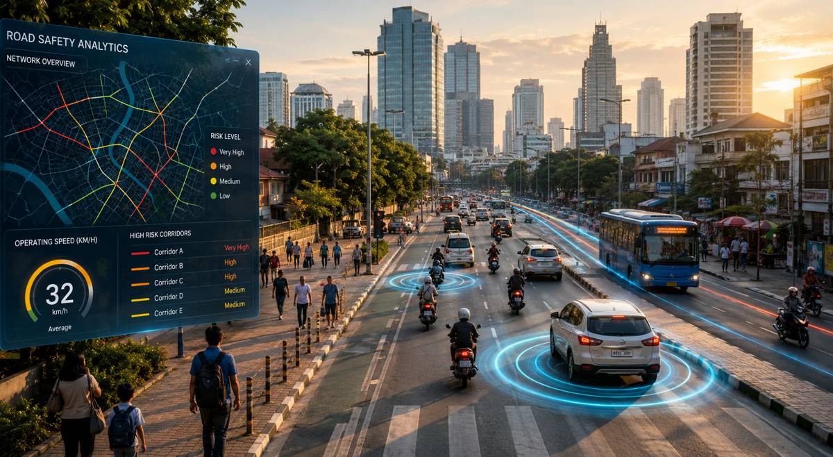
Rethinking Speed Limits with AI for Safer Roads
Road safety has long focused on one central question: are drivers obeying the speed limit? Yet a growing body of evidence suggests policymakers may need to ask a different question altogether. Are the speed limits themselves safe?
That challenge sits at the heart of a recent analysis published by the Asian Development Bank (ADB), authored by James Leather, Director of ADB’s Transport Sector Office, Priti Gautam, Senior Transport Specialist and Road Safety Lead, and Richard Owen, data scientist and CEO of Agilysis. Their work explores how advances in artificial intelligence, mobility data and geospatial analytics are creating new opportunities to review speed limits systematically, identify dangerous corridors, and prioritise interventions before crashes occur.
The discussion arrives at a critical moment. Across Asia and the Pacific, hundreds of thousands of people lose their lives on roads every year, while millions more suffer injuries that affect families, communities and economies. According to international estimates from the World Health Organization, road crashes remain among the leading causes of death globally, particularly for young people, creating economic losses that often exceed several percentage points of national GDP. Transport agencies are increasingly recognising that enforcement alone cannot solve the problem if speed limits no longer reflect the realities of modern road environments.
What makes the latest generation of analytical tools significant is their ability to move road safety from a reactive discipline to a predictive one. Rather than waiting for collision statistics to accumulate over years, governments can now use data generated from millions of vehicle journeys to identify where posted speed limits may already be creating unacceptable levels of risk.
Briefing
- New AI and mobility data tools allow agencies to assess speed limits across entire road networks rather than relying solely on traditional surveys.
- Many speed limits across Asia and the Pacific were established decades ago and may no longer reflect current traffic conditions or road users.
- Predictive analytics can identify dangerous corridors before serious crashes occur, enabling proactive intervention.
- International examples from Helsinki, London and New York demonstrate the safety benefits of lower urban speed limits combined with improved road design and enforcement.
- The ADB-led AI for Safer Roads Innovation Challenge aims to provide governments with practical tools for identifying outdated speed limits and reducing road trauma.
The Hidden Cost of Outdated Speed Policies
Infrastructure evolves constantly, but speed regulations often do not. Roads originally designed for relatively low traffic volumes may now carry dense flows of cars, motorcycles, buses, freight vehicles, cyclists and pedestrians throughout the day. Yet in many locations, the legal speed limits remain largely unchanged.
This disconnect can create a dangerous mismatch between policy and reality. A road that once functioned as a peripheral route may now pass through densely populated urban districts. Commercial developments, schools, healthcare facilities and public transport hubs frequently emerge around transport corridors, transforming the risk profile without triggering a systematic review of speed management practices.
The consequences are measured not only in fatalities but also in economic terms. The World Bank estimates that road traffic crashes cost countries billions of dollars annually through healthcare expenditure, lost productivity, emergency response costs and infrastructure damage. For developing economies seeking sustainable growth, reducing road trauma is increasingly viewed as an economic necessity as much as a public health priority.
Traditional methods of reviewing speed limits often struggle to keep pace with these changes. Periodic engineering assessments, roadside surveys and manual traffic studies remain valuable tools, but they are expensive, labour-intensive and limited in coverage. Most importantly, they provide only snapshots of conditions rather than continuous insight into how roads are used over time.
Human Tolerance Sets the Real Speed Limit
At the centre of modern road safety thinking lies a simple reality: human beings can only withstand certain levels of impact energy.
Research underpinning the Safe System approach demonstrates that survival probabilities decline dramatically as impact speeds increase. Pedestrians struck at approximately 30 km/h have a substantially greater chance of survival than those hit at 50 km/h. Similar thresholds exist for vehicle occupants involved in side-impact and head-on collisions, where crash forces rapidly exceed human tolerance levels.
These findings have transformed the way many transport authorities think about road safety. Rather than assuming perfect behaviour from drivers, cyclists and pedestrians, the Safe System philosophy accepts that mistakes will occur. Roads, vehicles, regulations and operating speeds must therefore be designed to ensure those inevitable mistakes do not result in death or serious injury.
This represents a fundamental shift in responsibility. Safety becomes a shared obligation between road users, infrastructure designers, vehicle manufacturers and policymakers. Speed management is no longer merely about compliance; it becomes a tool for managing kinetic energy within survivable limits.
From Spot Surveys to Network-Wide Intelligence
For decades, transport planners relied heavily on roadside monitoring equipment and periodic traffic studies to understand operating speeds. While effective in specific locations, these techniques provide limited visibility across vast national road networks.
The rapid growth of connected mobility technologies has changed that equation dramatically. GPS-enabled devices now generate enormous volumes of anonymous movement data every day. Vehicles equipped with navigation systems, fleet telematics platforms and smartphone applications collectively create a detailed picture of travel patterns across entire countries.
By analysing millions of journeys, agencies can identify how roads function in practice rather than how they were intended to operate when originally designed. Speed distributions, congestion patterns and route preferences emerge naturally from the data, revealing trends that traditional surveys might miss entirely.
When combined with geographic information systems, digital road inventories and street-level imagery, these datasets become even more powerful. Analysts can examine relationships between operating speeds, surrounding land use, intersection density, pedestrian activity and roadway geometry. The result is a far more comprehensive understanding of risk than was previously possible.
How Artificial Intelligence Can Predict Risk Before Crashes Occur
Artificial intelligence is increasingly being applied to transport infrastructure management, from predictive maintenance of bridges to optimisation of traffic signals. Road safety is becoming another major area of application.
Machine learning systems excel at identifying patterns within large, complex datasets. By combining speed information, road characteristics, environmental conditions and traffic behaviour, AI models can identify locations where posted speed limits appear inconsistent with established safety principles.
This capability is particularly valuable because crash data often arrives too late. Serious collisions may take years to accumulate before a location attracts official attention. During that period, preventable injuries and fatalities continue to occur.
Predictive risk assessment changes the equation. Instead of waiting for statistical evidence of harm, authorities can identify corridors exhibiting characteristics associated with elevated crash risk and intervene proactively. This may involve revising speed limits, redesigning junctions, introducing traffic calming measures or improving facilities for vulnerable road users.
Such approaches align closely with broader smart infrastructure initiatives currently being adopted worldwide. Roads are increasingly viewed as dynamic systems capable of generating insights and supporting data-driven decision-making rather than simply providing physical connectivity.
Lessons From Cities That Reduced Speeds
Evidence supporting lower urban speed limits continues to accumulate from cities around the world.
In Helsinki, one of Europe’s most notable road safety success stories has emerged through a combination of lower speed limits, redesigned streets and targeted enforcement. More than half of the city’s street network now operates with 30 km/h limits, contributing to a remarkable decline in road fatalities. City officials have consistently cited speed management as a central component of their broader Vision Zero strategy.
London has experienced comparable benefits. Research examining 20 mph zones found significant reductions in fatal and serious injuries following implementation. These measures were accompanied by physical design changes that encouraged drivers to adopt safer speeds naturally rather than relying exclusively on enforcement.
New York City’s Vision Zero programme offers another example. Lower speed limits, redesigned intersections, pedestrian safety improvements and enforcement initiatives have collectively contributed to substantial reductions in traffic fatalities over the past decade.
The common thread across these examples is that speed management rarely operates in isolation. Successful programmes combine policy changes with infrastructure improvements, public engagement and enforcement strategies. Together, these elements create road environments where safer speeds become the intuitive choice.
Building Practical Tools for Governments
The challenge facing many countries is not understanding the importance of speed management but identifying where intervention will produce the greatest benefit.
This is where practical decision-support tools become essential. Dashboards that visualise speed data, risk indicators and infrastructure characteristics can help agencies prioritise investments and policy changes more effectively.
Rather than conducting network-wide reviews manually, planners could focus resources on locations where data suggests the greatest mismatch between posted speeds and actual risk conditions. Schools, market districts, busy pedestrian corridors and complex junctions could be highlighted automatically, enabling faster responses.
Such tools also offer significant advantages for developing economies where technical resources may be limited. By automating much of the analytical process, governments can make more informed decisions without requiring extensive specialist teams or costly survey programmes.
The potential extends beyond static reviews. As mobility data continues to expand, future systems may enable continuous monitoring of road conditions and travel behaviour, supporting regular updates to speed management policies based on current realities rather than historical assumptions.
A New Era for Road Safety Management
The transport sector is entering an era in which infrastructure decisions can be guided by unprecedented levels of evidence. Artificial intelligence, mobility analytics and geospatial technologies are providing planners with tools that would have seemed impossible only a decade ago.
The ADB-led AI for Safer Roads Innovation Challenge reflects this transformation. Developed in partnership with the International Telecommunication Union (ITU), AI for Good, the World Bank Group and the Asia Pacific Road Safety Observatory, the initiative seeks to harness emerging technologies to help governments identify risk and improve road safety outcomes. Funding support comes from the Japan Fund for Prosperous and Resilient Asia and the Pacific and the High-Level Technology Fund.
Ultimately, safer roads depend on more than driver behaviour. They depend on whether transport systems are designed around realistic human capabilities and contemporary patterns of road use. As analytical tools become more sophisticated and accessible, governments have an opportunity to reassess long-standing assumptions and ensure that speed limits reflect present-day realities rather than historical conditions.
The question is no longer whether technology can identify unsafe speed environments. Increasingly, the challenge is how quickly transport agencies can turn those insights into action that saves lives.