INRIX Predictive Intelligence Reshapes Parking and Urban Mobility
For years, parking sat in an awkward corner of transport planning. Roads expanded, junctions were redesigned, public transport networks evolved and digital traffic systems matured, yet parking often remained rooted in static maps, outdated inventories and broad assumptions about availability. Drivers absorbed the inefficiency. Extra circulation was accepted as part of the urban experience. If people needed to drive around for ten minutes searching for a space, that was simply how cities worked.
That view is becoming increasingly difficult to justify. Modern mobility systems are expected to be connected, efficient and responsive. Navigation platforms now calculate live travel conditions in seconds, vehicles increasingly communicate with digital infrastructure, and city authorities face mounting pressure to reduce congestion without endlessly expanding physical road networks. Parking, once treated as an endpoint, is becoming part of the journey itself.
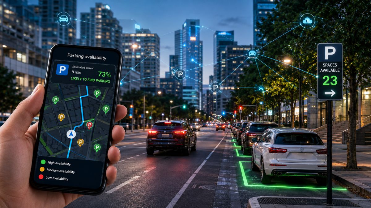
INRIX’s expanded deployment of its predictive parking and curb intelligence platform. Rather than approaching parking as a catalogue of locations and attributes, the company is positioning it as a decision-making layer designed to forecast parking conditions before arrival. The broader argument is straightforward enough: knowing where parking exists is becoming less valuable than understanding whether drivers can realistically use it when they get there.
For infrastructure leaders, vehicle manufacturers and policymakers, that distinction carries weight. Parking intelligence increasingly influences everything from digital road strategies and curb management to autonomous mobility planning and urban investment decisions.
Briefing
- INRIX has expanded deployment of its predictive parking and curb intelligence platform globally
- The platform prioritises usable parking inventory and estimated availability over static location databases
- Real-time and historical transport inputs are combined to forecast conditions before arrival
- Parking and curb intelligence are becoming increasingly important to connected mobility ecosystems
- Predictive models are creating new opportunities to reduce congestion and improve urban efficiency
Parking Data Is Growing Up
Transport technology has traditionally measured parking in terms of quantity. More locations meant better coverage. More attributes suggested greater sophistication. Larger databases became shorthand for capability. Yet quantity alone rarely reflects reality.
Anyone who drives regularly through a busy city understands the problem instinctively. A map showing available parking may not reveal loading restrictions, temporary controls, occupancy patterns, local regulations, delivery activity or changing demand conditions. Drivers often arrive to discover that available parking exists only in theory.
INRIX’s latest positioning attempts to address that gap. According to the company, its expanded parking intelligence capability combines verified inventory, dynamic curb information, predictive availability modelling and continuous validation from connected vehicle data to create a more operational picture of how parking actually functions.
The company reports that its platform now incorporates more than 50 petabytes of transportation information and maps over seven million parking locations covering approximately 48 million spaces worldwide. Coverage extends across 22,000 cities in 145 countries, supported by around 300 million vehicles and connected devices generating approximately 44 billion daily observations. Those figures represent scale, but INRIX’s emphasis is less about volume and more about interpretation.
Its argument is that mobility platforms no longer need larger parking lists. They need better decisions.
The Most Valuable Space in Cities May Be the Curb
One of the more significant developments in urban transport over the past decade has been the revaluation of curb space.
Historically, the curb was managed through local regulations, signage and periodic enforcement. Today, that same space has become a contested operational zone supporting passenger drop-offs, logistics, ride-hailing, public transport, electric charging infrastructure, micromobility services and short-term parking. Demand continues to rise while available space remains largely fixed. That creates a planning challenge.
Cities increasingly require detailed operational awareness of curb activity if they want to reduce congestion and improve accessibility. Static regulations are proving insufficient where traffic conditions, delivery demand and mobility behaviour can shift hour by hour.
INRIX’s expanded platform incorporates curb-level observations including restrictions, rates and usage conditions. Combined with real-time updates and vehicle telemetry, this creates a more dynamic representation of urban access conditions rather than a simple inventory of legal parking locations.
For planners and operators, the practical outcome is potentially significant. Drivers and navigation systems can be directed toward parking that is genuinely usable instead of simply nearby.
That distinction sounds subtle. Operationally, it changes everything.
Moving From Parking Locations to Parking Probability
Perhaps the most interesting element of the announcement is not the data itself but the change in thinking behind it.
Traditional parking solutions answer a basic question: where could someone park? Predictive parking attempts to answer a different question altogether: what is the likelihood of finding a usable space when arriving?
To do this, INRIX combines connected vehicle information, traffic conditions, historical behaviour patterns and live curb activity to estimate availability at estimated arrival time. According to the company, models update every fifteen minutes and forecast demand as far as seven days into the future.
That approach begins to align parking with the logic already used elsewhere in intelligent transport systems. Modern traffic management increasingly relies on prediction rather than reaction. Infrastructure operators monitor expected conditions, not simply observed events. Parking appears to be moving in the same direction. This becomes especially relevant as automated and connected mobility develops.
Vehicles capable of advanced navigation, automated drop-offs or partial autonomy require greater certainty around destination conditions. Routing decisions increasingly depend on knowing not just where a destination sits, but how accessible it will be when the vehicle arrives.
Parking intelligence therefore becomes another layer in the digital transport stack.
Accuracy Matters More Than Scale
Large transport datasets attract attention, but decision-makers are becoming increasingly cautious about headline numbers.
Coverage statistics look impressive until real-world conditions expose gaps in quality. One notable aspect of INRIX’s approach is the amount of emphasis placed on validation and testing methodology. According to the company, its framework targets at least 95 percent coverage fidelity and at least 90 percent attribution accuracy across driver-facing information including pricing, parking restrictions and operational rules.
Performance measurement reportedly includes statistically significant sample sizes, a 95 percent confidence level and monthly benchmarking against satellite imagery, municipal datasets and APIs. Ground-truth testing is also conducted periodically to assess live operational conditions.
Between January and April 2026, INRIX states that testing across 46 city instances in 12 countries demonstrated approximately 99 percent coverage and accuracy performance during field validation exercises. Locations referenced include London, Berlin, Boston, Los Angeles and San Diego.
For public authorities and mobility providers, validation is increasingly becoming the differentiator. Transport agencies already manage complex investment environments and growing expectations around digital accountability. Solutions that demonstrate repeatable performance are likely to gain greater traction than systems built primarily around scale.
Creating One Continuous Mobility Journey
Parking is increasingly difficult to separate from the wider transport experience.
A driver begins with route planning, encounters changing traffic conditions, responds to restrictions and ultimately completes the journey at the curb. Historically, each stage has been managed by different systems using different data sources. That fragmentation creates inefficiencies.
INRIX describes its platform as an intelligence layer connecting navigation providers, mapping environments, vehicle manufacturers and city management systems. The objective is to allow transport decisions to continue seamlessly from departure through to arrival rather than handing responsibility between disconnected applications.
The concept reflects a broader shift visible across infrastructure. Road networks are increasingly being treated as digital environments where value comes not simply from asphalt and concrete but from information layers that improve operational performance. Smart infrastructure programmes across Europe, North America and Asia continue moving in this direction, integrating sensing, predictive analytics and automated decision support into everyday operations.
Parking now appears to be joining that transition.
Building Cities That Know Before Drivers Arrive
Urban mobility rarely changes through dramatic breakthroughs. More often, it improves through thousands of small efficiencies that remove friction from everyday movement. Predictive parking falls into that category.
Cities are unlikely to build their way out of congestion through additional parking supply alone. Land constraints, environmental targets and investment realities increasingly push authorities toward extracting more value from existing assets. That creates an opportunity for intelligence-led approaches.
By combining real-world validation, predictive modelling and connected vehicle inputs, parking systems begin shifting from passive information tools to active infrastructure components. Drivers spend less time circulating, cities gain better operational visibility and mobility platforms become more reliable.
Parking may never become the most glamorous part of transport planning.
Still, as connected mobility matures and vehicles become more capable of acting on data before arrival, knowing where a vehicle can realistically stop may prove every bit as important as knowing how quickly it can get there.