






Topcon Brings Digital Twin Technology to Vitruvius’ Rediscovered Roman Basilica
Nearly 2,000 years after the Roman architect Vitruvius described the basilica he designed in the ancient city of Fanum Fortunae, archaeologists are examining the remains of the building using surveying technologies that would have been unimaginable to its original builders. Topcon Positioning Group in Italy has entered into a scientific sponsorship agreement with Italy’s Ministry of Culture to support the investigation, documentation and digital reconstruction of the recently discovered structure in Fano, on the Adriatic coast.
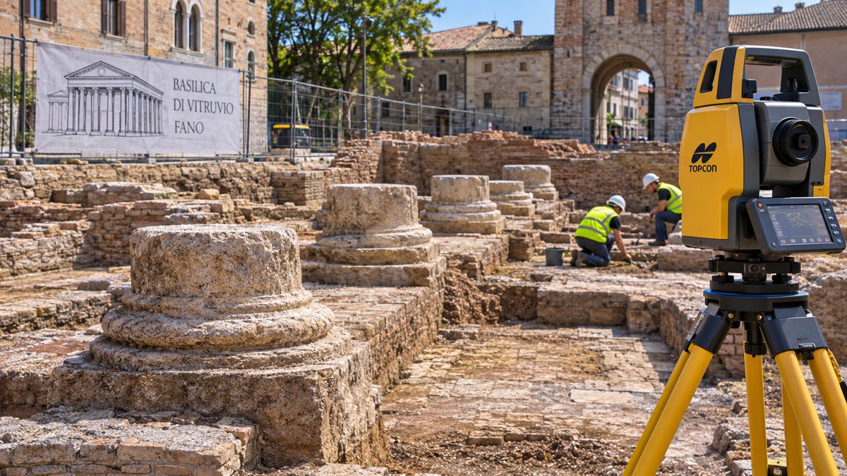
The agreement with the Superintendency of Archaeology, Fine Arts and Landscape (SABAP) will bring 3D laser scanning, GNSS surveying, photogrammetry, ground-penetrating radar and other geospatial technologies to an active archaeological excavation. Alongside recording the surviving structures, the project aims to develop a digital twin that can support research, conservation and public interpretation.
The basilica was identified in January 2026 during archaeological investigations associated with the redevelopment of Piazza Andrea Costa. Excavations revealed monumental column foundations and substantial Roman masonry corresponding closely to the description preserved in Vitruvius’ architectural treatise, De Architectura. The discovery has given researchers a rare opportunity to compare an ancient architect’s own account with the physical remains of a building he is believed to have designed.
Briefing
- Topcon Positioning Group in Italy has agreed to support archaeological surveying and digital documentation at the Basilica of Vitruvius in Fano.
- The project will combine 3D laser scanning, GNSS, photogrammetry, mobile mapping, ground-penetrating radar and digital workflow software.
- The basilica was identified in January 2026, with subsequent excavations revealing six monumental column remains and further architectural evidence.
- A digital twin is planned to support archaeological research, conservation and public interpretation.
- The project applies established construction and infrastructure surveying technologies to the investigation of an important Roman architectural site.
A Roman Building Known Through Its Architect’s Own Words
Marcus Vitruvius Pollio occupies an unusual position in architectural history. His ten-volume treatise, De Architectura, is the only substantial architectural treatise from classical antiquity to have survived intact, influencing generations of architects, engineers and scholars. Yet until the excavations at Fano, the physical remains of the basilica he explicitly described constructing had not been securely identified.
The building stood in the Roman settlement of Fanum Fortunae and served as a civic structure rather than a religious church in the modern sense. Roman basilicas accommodated public administration, legal proceedings and commercial activity, with large internal spaces arranged around colonnades. Vitruvius described an imposing rectangular building, approximately 50 metres long and 35 metres wide, with eight columns along each longer side and four along the shorter sides.
The discovery emerged from archaeological investigations undertaken as part of a publicly funded urban redevelopment programme. When excavations exposed substantial Roman masonry and column foundations, researchers compared their positions and dimensions against Vitruvius’ surviving description. Italy’s Ministry of Culture announced the identification on 19 January 2026, reporting an exceptionally close correspondence between the excavated layout and the historical account.
The monumental columns provided particularly compelling evidence. Approximately 1.5 metres in diameter and estimated to have originally stood around 15 metres high, they formed part of a substantial structural arrangement supporting the basilica’s upper level. Their dimensions and positions helped establish the relationship between the archaeological remains and the building described by Vitruvius.
Further archaeological work has continued to develop the picture. In July, SABAP reported the identification of a sixth column base, additional Roman flooring and sections of perimeter masonry. Excavations also revealed evidence of subsequent reuse during the medieval period, including ceramics dating from the eleventh and twelfth centuries. An apsidal wall found near the centre of the complex has raised further questions about the arrangement of a structure associated with Augustus.
Much of the basilica remains to be investigated, and the archaeological evidence continues to develop as excavation progresses. Each newly exposed foundation, floor surface or fragment of masonry adds to the understanding of how the building was constructed, modified and eventually absorbed into the later city.
Surveying an Active Archaeological Site
Documenting an archaeological excavation presents challenges quite different from recording an established building or an active construction project. Each stage of investigation exposes new evidence while potentially removing the deposits and physical relationships that surrounded it. Once an archaeological layer has been excavated, its original arrangement cannot be restored.
At Fano, Topcon’s surveying technologies will allow exposed masonry, column foundations, floors and other surviving features to be recorded as excavation advances. Three-dimensional laser scanning can capture dense collections of spatial measurements, creating detailed point clouds of surfaces and structures at particular stages of the work. These records may preserve geometric information that becomes inaccessible as investigations continue or conservation measures are introduced.
Photogrammetry will complement the scanning work by using overlapping photographs to generate three-dimensional representations of visible surfaces. The resulting models can retain colour and texture alongside geometry, allowing researchers to examine masonry construction, material differences and the relationships between individual features.
Maintaining consistent positional control will be important as the investigation extends across the site. GNSS surveying can establish a common spatial reference for measurements collected at different times, enabling individual excavations, structures and survey datasets to be related accurately to one another. The information can then be incorporated into digital models without losing the geographical relationships between separate discoveries.
Ground-penetrating radar offers a means of investigating potential subsurface features without immediately disturbing the ground. By transmitting electromagnetic signals and measuring their reflections, the equipment can identify variations that may indicate buried structures or changes in material properties. Interpretation remains dependent on soil conditions, moisture, depth and the character of the deposits, and any anomalies must be assessed alongside the archaeological evidence.
Mobile mapping and digital workflow software will provide further methods of collecting, organising and sharing information. Topcon has also committed to training and scientific coordination, supporting the integration of the surveying systems into the archaeological team’s established working methods.
The basilica lies within an existing urban environment, where excavation must be coordinated with public access, surrounding infrastructure and the protection of exposed remains. In April 2026, the Municipality of Fano and SABAP formalised an agreement covering further archaeological investigations, documentation, site safety and temporary conservation measures. The Topcon sponsorship adds specialist technical capability to work already being undertaken by the relevant heritage authorities.
The announcement does not identify individual instrument models or specify surveying tolerances, but the combination of techniques offers several complementary ways of examining the site. Laser scanning and photogrammetry can document visible remains, GNSS can maintain their spatial relationships, and geophysical investigations may help guide further research beneath the surrounding ground.
Building a Digital Twin of an Ancient Structure
The second objective of the sponsorship is the development of a digital twin incorporating information gathered during the investigation. The intention is to create a detailed digital representation of the basilica that can support continuing research, conservation work and new ways of presenting the site.
An archaeological digital twin requires particular care in distinguishing between what has physically survived and what researchers believe may once have existed. Although the excavations have revealed substantial evidence of the basilica’s original arrangement, much of the building no longer survives above ground. Reconstructions of its original height, roof structure, interior finishes and architectural decoration must therefore draw on combinations of measured remains, historical descriptions and scholarly interpretation.
A well-managed digital model can preserve those distinctions, allowing researchers to examine the surviving structures while exploring alternative reconstructions without presenting assumptions as measured facts. The underlying survey information can also be retained and revisited as further discoveries emerge, rather than requiring each new interpretation to begin with a fresh reconstruction of the site.
Successive surveys may provide conservation specialists with a means of examining changes in exposed masonry or other vulnerable features. Detecting deterioration reliably would require consistent measurement procedures, appropriate accuracy controls and an understanding of environmental effects. Although the sponsorship announcement refers to real-time monitoring, it does not specify whether continuous sensors, periodic surveys or another monitoring arrangement will be employed.
Digital representations could eventually provide opportunities for researchers, students and visitors to examine parts of the building that are inaccessible or unsuitable for unrestricted public access. They may also allow the basilica’s surviving remains to be viewed alongside interpretations of its original architectural arrangement, provided the distinction between evidence and reconstruction remains clear.
Ivan Di Federico, president and CEO of Topcon Positioning Systems, said: “Through our geospatial and reality-capture technologies, a digital twin will be created to support research, conservation, and public engagement, providing lasting value for archaeology, academia, and cultural heritage.”
The project also raises familiar questions about the long-term management of digital engineering information. Point clouds, photographic surveys, geophysical results and interpretive models can generate substantial volumes of data in different formats, and their usefulness depends on reliable metadata, clear relationships between datasets and continued accessibility.
For an archaeological record intended to serve future generations, interoperability and long-term preservation are particularly relevant. Equipment and software platforms will change, while researchers may return to the original measurements decades after the excavation has been completed. Retaining the underlying survey data alongside the interpretive models will help ensure that future discoveries can be assessed against the original evidence.
These considerations are equally familiar within construction and infrastructure engineering, where digital surveys increasingly support asset management, structural inspection and the documentation of existing facilities. At Fano, the same principles are being applied to a building whose original construction predates modern surveying instruments by nearly two millennia.
Andrea Pessina, superintendent of SABAP Ancona and Pesaro-Urbino, welcomed the collaboration: “We are pleased to have the technological support of Topcon on this important initiative. Advanced surveying and digital technologies will enhance our ability to study, preserve, and share this extraordinary archaeological discovery with the scientific community and the public.”
Preserving an Architectural Reference Point
Vitruvius’ influence extends far beyond the Roman buildings he described. His writing helped preserve classical knowledge of architectural proportion, building materials, structural design and the relationship between function and form. Centuries later, his principles informed Renaissance architectural scholarship, including Leonardo da Vinci’s celebrated study of human proportions, the Vitruvian Man.
The discovery at Fano offers an unusual opportunity to examine the relationship between architectural theory and actual construction. Measurements of the surviving columns, walls and foundations can be compared against a written account produced by the architect himself, providing evidence of how Roman builders translated design intentions into physical structures.
For Topcon, the sponsorship extends the application of geospatial technologies developed for construction, geomatics and infrastructure into the conservation of cultural heritage. The company has not disclosed the financial value of its contribution or a timetable for completing the digital twin, while SABAP retains responsibility for the archaeological investigation and preservation of the site.
Further excavation will undoubtedly refine the understanding of the basilica’s structural arrangement, construction sequence and subsequent history. The digital record will allow those findings to be examined against earlier observations, including details that may no longer be visible once excavation or conservation work has progressed.
Almost two thousand years after Vitruvius recorded the proportions and arrangement of his basilica, the foundations emerging beneath modern Fano are providing a physical counterpart to his written description. With each newly surveyed column base and section of masonry, archaeologists can compare the surviving building against the dimensions set down by its architect, bringing the original construction into increasingly precise focus.
Key Industry Questions
- What is the Basilica of Vitruvius in Fano? It is a Roman civic building described by the architect Marcus Vitruvius Pollio in De Architectura. Its remains were identified in January 2026 beneath Piazza Andrea Costa in Fano, Italy.
- Why is the discovery particularly important to architectural history? Vitruvius explicitly described his involvement in constructing the basilica, making it a rare opportunity to compare an ancient architect’s written account with the surviving physical remains of a building attributed to him.
- What surveying technology will Topcon provide? The announced programme includes 3D laser scanning, GNSS surveying, photogrammetry, mobile mapping, ground-penetrating radar and digital workflow software, supported by training and scientific coordination.
- What is the difference between a digital twin and a 3D reconstruction? A 3D reconstruction represents the geometry or appearance of a structure. A digital twin can incorporate measured geometry alongside linked documentation, observations and potentially updated monitoring information. The detailed scope of the Fano system has not yet been announced.
- How can ground-penetrating radar assist archaeological investigations? GPR can detect variations in subsurface electromagnetic properties that may indicate buried foundations, interfaces or other features. Interpretation requires archaeological context and, where appropriate, verification through additional investigation methods.
- Can laser scanning detect deterioration in ancient masonry? Repeat scans can help identify geometric changes where suitable measurement accuracy and consistent survey conditions are maintained. They cannot independently establish the causes of deterioration or replace specialist material assessments.
- Will the entire basilica be reconstructed digitally? The agreement establishes an intention to develop a digital twin, but does not confirm the extent of architectural reconstruction or how hypothetical elements will be represented.
- Who is responsible for the archaeological project? The investigation is overseen by the relevant Italian heritage authorities, including SABAP, in coordination with the Municipality of Fano. Topcon is contributing surveying technology and technical expertise under a scientific sponsorship agreement.
Strategic Takeaways
- Integrated surveying: Combining laser scanning, photogrammetry, GNSS and geophysical methods can produce a more complete archaeological record than any single measurement technique.
- Progressive documentation: Recording successive excavation stages preserves geometric information and spatial relationships that may disappear as archaeological investigations advance.
- Evidence-based reconstruction: Digital models must distinguish measured remains from historical interpretation to maintain their scientific credibility.
- Long-term data preservation: Interoperable survey datasets, supported by reliable metadata, can remain useful to researchers beyond the operational lives of the instruments and software that produced them.
- Cross-sector application: The Fano project demonstrates how geospatial systems used in construction and infrastructure can support archaeological investigation, conservation and heritage management.