Topcon And GSSI Integrate Ground Penetrating Radar With GNSS Mapping
Modern infrastructure projects increasingly depend on accurate data, not only about what lies above ground but also about the hidden networks buried beneath the surface. Utilities, structural elements, voids, and geological conditions can dramatically influence the cost, safety, and timeline of construction works. Yet despite advances in digital engineering, subsurface information often remains fragmented, forcing contractors and planners to rely on incomplete datasets.
A new collaboration between Topcon Positioning Systems and Geophysical Survey Systems Inc. aims to close that gap. By combining ground penetrating radar technology with high precision satellite positioning and cloud-based data workflows, the two companies are introducing an integrated system designed to transform how infrastructure professionals detect, analyse and interpret what lies beneath the surface.
The partnership reflects a broader industry shift toward unified digital workflows. As infrastructure projects grow in scale and complexity, the ability to merge subsurface detection with accurate geospatial context is becoming essential for engineers, surveyors and asset managers alike.
The Rising Importance Of Subsurface Intelligence
Subsurface conditions have always influenced construction decisions, but historically they were often assessed through limited sampling or manual surveys. Boreholes, trial pits and fragmented utility records frequently left gaps in knowledge. When surprises emerged during excavation, projects could face costly delays, redesigns or safety hazards.
In modern construction environments, those risks carry greater consequences. Infrastructure assets now coexist with dense utility networks, fibre optic cables, drainage systems and legacy structures installed decades earlier. According to research from the American Society of Civil Engineers, utility strikes and unexpected underground conditions remain among the leading causes of project overruns in urban construction.
Ground penetrating radar has long offered a non-destructive solution to this problem. By transmitting electromagnetic waves into the ground and analysing reflections, GPR systems can detect buried utilities, structural defects and geological anomalies. However, traditional GPR surveys have often produced datasets that were difficult to integrate with modern geospatial workflows.
This is precisely where the Topcon and GSSI collaboration aims to make a difference. By aligning radar detection data with precise GNSS positioning and cloud-based processing tools, the combined system seeks to transform raw subsurface scans into geospatially accurate, decision-ready insights.
Integrating Radar Detection With Precision Positioning
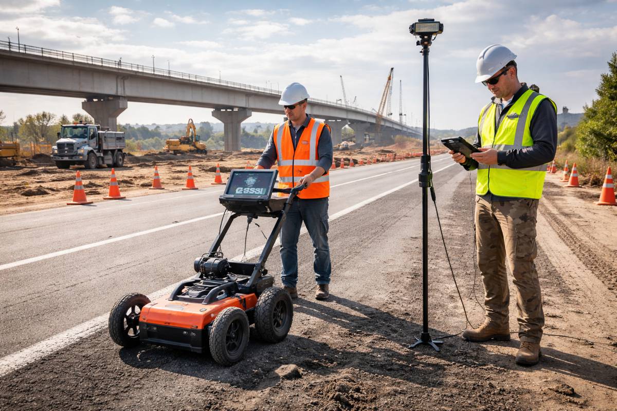
At the core of the new solution is the integration of GSSI’s advanced radar platforms with Topcon’s high accuracy positioning and digital workflow tools. The system combines radar data from GSSI equipment with the Topcon HiPer XR GNSS receiver, correction services delivered through Topnet Live, and cloud-based processing via Topcon Collage Web.
The result is a streamlined workflow that connects field data collection directly to digital analysis environments. Survey teams can capture radar scans and geospatial positioning simultaneously, ensuring that every detected object or anomaly is precisely located within a project’s coordinate system.
Ron Oberlander, head of the Topcon Geomatics Platform, described the value of the collaboration in practical terms: “GSSI is a long-standing industry leader in ground penetrating radar (GPR) systems, and we are excited to work with them on providing industry professionals with an advanced, integrated solution.
“By combining GSSI’s GPR technology with Topcon’s HiPer XR GNSS receiver, Topnet Live correction services, and Collage Web mass-data workflow software, we are bridging subsurface detection and spatial context from field to analysis.”
By linking radar scans with accurate spatial positioning, the system effectively connects two historically separate datasets. Instead of interpreting radar profiles independently, engineers can visualise subsurface features within their broader digital construction models.
Bringing Context To Complex Infrastructure Environments
One of the biggest challenges facing construction professionals today is the fragmentation of data across project teams. Surveyors, engineers, asset managers and contractors often work with separate datasets that must be manually reconciled. Subsurface information frequently sits outside these workflows, limiting its usefulness.
Integrating radar detection with GNSS positioning helps bring that information into the same digital ecosystem as other project data. Radar scans can be georeferenced with high precision and uploaded to collaborative platforms, allowing stakeholders to review and interpret findings collectively.
Chris Green, chief executive officer of GSSI, highlighted the broader value of merging radar data with geospatial context: “Collaborating with Topcon allows us to unify GPR data and GNSS data to deliver visual, decision-ready insights, providing a more complete picture of the world above and below the surface.
“Together, GSSI and Topcon are helping customers plan smarter, validate faster, and deliver higher quality outcomes with fewer surprises.”
In practical terms, this integration allows teams to visualise buried assets in relation to road alignments, building foundations, pipelines and other infrastructure features. That context reduces uncertainty and enables more informed decision-making during planning and construction.
Applications Across Infrastructure And Construction
The combined technology platform supports a wide range of applications across the infrastructure lifecycle. From early-stage surveys to asset management, subsurface intelligence plays a role in virtually every phase of a project.
Some of the most immediate applications include:
- Utility Mapping: Detecting and mapping buried cables, pipes and conduits before excavation begins
- Concrete Inspection: Identifying reinforcement bars, voids and structural defects within concrete structures
- Transportation Infrastructure Assessment: Evaluating pavement layers and road conditions
- Geotechnical Investigation: Identifying soil anomalies or underground voids
- Archaeological Surveys: Mapping buried artefacts without disturbing the site
In transportation infrastructure, radar surveys are frequently used to assess pavement thickness and detect structural deterioration. Highway agencies worldwide rely on these methods to evaluate road conditions without interrupting traffic.
The integration of positioning technology enhances these capabilities by ensuring that every radar scan can be accurately located within asset management systems. That level of spatial precision supports long-term infrastructure monitoring and maintenance planning.
Digital Workflows Reshaping Construction Data
The collaboration also reflects a larger transformation underway in the construction industry. Digital technologies are rapidly reshaping how infrastructure projects are planned, built and managed.
Tools such as building information modelling, digital twins and advanced surveying technologies are enabling project teams to collect unprecedented volumes of data. Yet turning that data into actionable insights remains a persistent challenge.
Mass data workflow platforms such as Topcon Collage Web play an important role in addressing this issue. These systems allow teams to process, visualise and analyse large datasets from multiple sources, including LiDAR, photogrammetry and radar scanning.
By feeding georeferenced radar data into these workflows, engineers can incorporate subsurface intelligence directly into digital project models. This creates a more comprehensive understanding of site conditions, reducing uncertainty and enabling more efficient project planning.
Industry Context And Market Growth
The global market for ground penetrating radar and subsurface imaging technologies has grown steadily over the past decade. Analysts attribute this growth to rising infrastructure investment and increasing awareness of underground asset risks.
According to research from MarketsandMarkets, the global ground penetrating radar market is projected to expand significantly in the coming years as governments and infrastructure operators invest in asset monitoring and underground mapping technologies.
Urbanisation also plays a key role. Cities around the world are expanding their transport networks, utilities and telecommunications infrastructure. In these dense environments, accurate subsurface mapping is critical to avoid damaging existing assets during construction.
Technological integration is becoming a defining trend within the sector. Rather than standalone surveying tools, the industry increasingly demands platforms that combine sensors, positioning systems and data analytics into unified workflows.
The Topcon and GSSI partnership fits squarely within this trajectory, reflecting the growing importance of integrated digital surveying solutions.
Showcasing The Technology At A Global Industry Event
The new integrated system will be showcased publicly during CONEXPO-CON/AGG, one of the world’s largest exhibitions for construction equipment and technology. Held in Las Vegas every three years, the event attracts tens of thousands of industry professionals from across the global construction ecosystem.
Trade shows like CONEXPO play an important role in demonstrating emerging technologies in real-world contexts. For companies developing digital construction tools, these events offer an opportunity to showcase how different systems interact within broader workflows.
Visitors will be able to see the integrated radar and positioning solution demonstrated at both the Topcon Positioning Systems booth and the GSSI booth, offering insight into how the combined technology functions in practice.
Precision Data Driving Better Infrastructure Decisions
Infrastructure projects are becoming more complex as cities expand, transportation systems modernise and utility networks grow denser. In this environment, incomplete subsurface knowledge can create costly surprises and safety risks.
The integration of ground penetrating radar with precision positioning technology offers a practical way to reduce those uncertainties. By combining radar detection with accurate spatial context and cloud-based data analysis, engineers gain a clearer picture of conditions both above and below ground.
For construction professionals, the value lies not simply in detecting hidden features but in understanding how they relate to the wider project environment. Accurate subsurface intelligence supports better planning, safer excavation and more efficient infrastructure management.
As digital workflows continue to reshape the construction sector, collaborations like the one between Topcon and GSSI highlight the growing importance of integrated technologies. By bridging the gap between subsurface detection and geospatial analysis, the industry moves one step closer to truly data-driven infrastructure delivery.