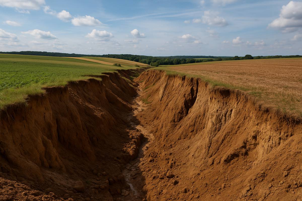
AI Unveils the Hidden Science Behind Gully Erosion
Gully erosion is a silent saboteur of agriculture, often carving destructive paths through fields after just one heavy downpour. It doesn’t just damage the land—it robs crops of nutrients, clogs waterways with sediment, and leaves farmers wrestling with costly land rehabilitation. For years, understanding where these gullies might form was as tricky as guessing next season’s weather.
Now, researchers at the University of Illinois Urbana-Champaign may have cracked the code. Their ground-breaking study fuses machine learning with a transparency-boosting AI method, offering a leap forward in predicting and understanding gully erosion patterns. Tested in Jefferson County, Illinois, their new methodology brings precision, clarity, and crucially, actionability to the fight against erosion.
High-Tech Meets High Stakes
Located in the Big Muddy River watershed and draining into Rend Lake, Jefferson County is no stranger to soil loss. Around 60% of the landscape is agricultural, dominated by corn and soybean fields that rely on stable terrain. The region’s rolling topography makes it particularly susceptible to erosion, setting the stage for a robust test of the new AI model.
The team prepared detailed gully erosion maps based on elevation data from 2012 and 2015. From there, they introduced a whopping 25 environmental variables into the model—from topography and precipitation to soil composition and vegetation cover. These factors were fed into a machine learning algorithm trained to sniff out the conditions most likely to produce erosion.
“We had conducted a previous study in the same area, but we applied only an individual machine learning model to predict gully erosion susceptibility,” explained lead author Jeongho Han, who recently earned his PhD from Illinois. “While that study provided a baseline understanding, it had limited predictive accuracy. Furthermore, we were not able to explain how the model made predictions. This research aims to address these two key limitations.”
The Stacking Model Advantage
As with any good recipe, it’s not just the ingredients but how they’re combined that makes the magic. In this case, the magic came from stacking—a technique that layers multiple machine learning models on top of each other to enhance performance.
The researchers evaluated 44 combinations of these stacked models and selected the top performers to create erosion susceptibility maps. The outcome? The best stacking model delivered an accuracy rate of 91.6% compared to 86% from the best individual model. That six-point jump could make all the difference in resource allocation and land conservation strategies.
But while accuracy is a big win, trust and transparency matter too—especially when decisions affect livelihoods and ecosystems. That’s where the SHAP method steps in.
Explainable AI with SHAP
Even the best AI models often operate as black boxes. They spit out predictions, but rarely explain how they got there. To solve this, the Illinois team used SHapley Additive exPlanations (SHAP), a technique that breaks down how much each variable contributes to a model’s prediction.
“When you use AI modeling, you get an output, but it’s like a black box. You don’t know how it was determined, so you don’t have any criteria to evaluate the results,” said Jorge Guzman, research assistant professor in Agricultural and Biological Engineering. “Explainable AI provides metrics that allow you to understand how different variables influence model predictions and how they interact with one another.”
SHAP revealed that the most influential predictor of erosion was the annual leaf area index of crops. Dense leaf cover, it turns out, acts like a shield against the pounding of rainfall, significantly reducing soil displacement.
From the Lab to the Land
One of the strongest aspects of this research is its practicality. The results aren’t locked away in academic jargon—they’re built to be used. Land managers, policymakers, and farmers can leverage this transparent AI model to make smarter, faster, and more targeted decisions.
Need to know which field to fortify before the next storm? Curious about where to focus conservation efforts or install erosion-control measures? The model doesn’t just guess; it shows you the “why” behind the “where.”
“By offering a transparent mechanism to evaluate how different features and models contribute to final decisions, this approach can be extended to broader environmental management and policy-making contexts, facilitating more informed and responsible resource allocation,” the researchers noted in the published paper.
The Broader Implications
Although this study focused on a specific region in Illinois, its implications stretch far beyond Jefferson County. The AI framework—especially with SHAP integration—could be deployed in other regions and environmental contexts where erosion, land degradation, or even flooding pose risks.
More importantly, this model offers a roadmap for blending AI with real-world usability. It’s a textbook case of how explainable AI can move from the lab to the field, helping those on the front lines of environmental management to act confidently and quickly.
Building Trust in AI-Powered Conservation
For landowners and conservationists, trust in technology is paramount. The combination of high-accuracy stacking models and SHAP’s interpretability offers a new gold standard. It proves that AI doesn’t have to be a mystery and, when done right, can become a vital tool in preserving our most precious resource: the land.