Real-Time Data Is Redefining Urban Emissions Mapping and Transport Policy
Cities have long struggled with a fundamental blind spot in transport planning: understanding exactly where, when, and how vehicle emissions occur. Traditional emissions inventories tend to rely on averaged data, periodic sampling, or broad modelling assumptions. While useful at a strategic level, these approaches often fall short when policymakers need to make precise, localised interventions.
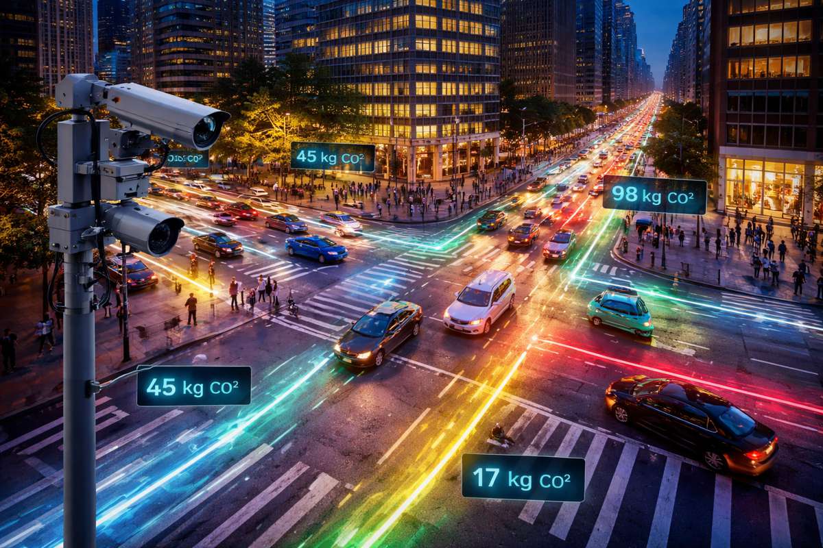
Now, researchers from MIT Senseable City Lab have demonstrated a method that could shift the balance decisively. By combining existing traffic cameras with anonymised mobile data, they have created a system capable of mapping vehicle emissions in near real time, down to individual streets and hourly variations. The implications for urban infrastructure planning, environmental policy, and transport engineering are significant.
At its core, the approach doesn’t rely on new infrastructure or costly sensor rollouts. Instead, it leverages what cities already have: traffic cameras, mobile data streams, and established emissions factors. That makes it not only technically compelling but commercially viable, particularly for cities facing tight budgets and growing regulatory pressure to decarbonise transport systems.
Briefing
- Combines traffic cameras and anonymised mobile data to map emissions at street level in near real time
- Achieves far greater accuracy than traditional citywide or sample-based emissions models
- Demonstrates measurable emissions reductions linked to congestion pricing policies
- Offers scalable, privacy-conscious deployment using existing infrastructure
- Enables policymakers to simulate transport interventions before implementation
Bridging the Gap Between Macro Estimates and Micro Reality
Urban emissions modelling has historically operated at two extremes. On one side are broad, city-level inventories that provide a general picture of pollution. On the other are highly detailed studies focusing on individual vehicles or small datasets, often impractical to scale across entire metropolitan areas.
The research published in Nature Sustainability addresses this gap directly. By integrating multiple data streams, the team has created a framework that delivers both scale and granularity. It enables city authorities to observe emissions patterns not just across districts, but along specific corridors and even individual junctions.
“Our model, by combining real-time traffic cameras with multiple data sources, allows extrapolating very detailed emission maps, down to a single road and hour of the day,” said Paolo Santi, a principal research scientist involved in the study. “Such detailed information can prove very helpful to support decision-making and understand effects of traffic and mobility interventions.”
This level of resolution changes the conversation. Instead of relying on assumptions about peak congestion or average vehicle behaviour, planners can now see how emissions fluctuate in response to signal timings, bottlenecks, or modal shifts. That insight opens the door to more targeted and effective interventions.
Turning Existing Infrastructure Into a Data Engine
A key strength of the model lies in its practicality. Rather than requiring new hardware deployments, it builds on infrastructure already embedded in most urban environments. In Manhattan, for example, researchers analysed data from 331 existing traffic cameras, supplementing it with anonymised mobility data from more than 1.75 million mobile devices.
Using computer vision techniques, the system categorised vehicles into 12 types, achieving a classification accuracy of 93 percent. Crucially, this process avoids identifying individual vehicles or licence plates, maintaining privacy while still extracting meaningful insights about traffic composition.
The integration of mobile data adds another layer of depth. It enables researchers to track broader movement patterns across the city, capturing how vehicles transition between roads, neighbourhoods, and time periods. When combined with established emissions factors, this creates a dynamic, citywide emissions model that reflects real-world conditions far more accurately than static datasets.
“The very basic idea is just to estimate traffic emissions using existing data sources in a cost-effective way,” explained Songhua Hu, one of the study’s lead authors.
Capturing the Hidden Impact of Traffic Signals
One of the more revealing aspects of the study concerns traffic signals. Stop-and-go driving patterns, often caused by signal timing and intersection design, are known to increase emissions. Yet many conventional models fail to account for this effect in any meaningful way.
By analysing camera data at junction level, the researchers were able to observe how signal cycles influence vehicle acceleration and deceleration patterns. This, in turn, allowed them to incorporate a more realistic representation of emissions into their model.
The result is a clearer understanding of how seemingly minor design decisions, such as signal phasing or junction layout, can have outsized environmental impacts. For transport engineers and urban planners, this insight could reshape how intersections are designed and managed.
It also aligns with broader trends in intelligent transport systems, where adaptive signal control and real-time traffic management are increasingly seen as tools for both congestion reduction and emissions control.
Testing Policy Scenarios Before They Happen
Perhaps the most valuable feature of the framework is its ability to simulate policy interventions. By adjusting variables such as traffic demand, vehicle mix, or travel timing, the model can estimate how emissions would change under different scenarios.
For instance, the researchers examined what would happen if a portion of private vehicle journeys shifted to buses. They also explored the impact of spreading peak travel demand over longer periods, effectively flattening rush hour.
These simulations provide policymakers with a sandbox environment for decision-making. Instead of relying on theoretical projections or delayed feedback, they can evaluate potential outcomes in advance and refine strategies accordingly.
Importantly, the study also highlights the risks of oversimplification. When the team replaced detailed emissions inputs with citywide averages, the resulting estimates varied significantly, ranging from a 49 percent underestimate to a 25 percent overestimate. That margin of error underscores the importance of granular data in shaping effective policy.
Real-World Evidence From Congestion Pricing
The framework was also applied to a real-world policy change: congestion pricing introduced in New York City in January 2025 for areas south of 60th Street in Manhattan. By analysing traffic and emissions data over several weeks, the researchers were able to quantify the policy’s impact.
Traffic volumes fell by around 10 percent, but emissions dropped by a more substantial 16 to 22 percent. This divergence highlights a critical point: small reductions in traffic can yield disproportionately large environmental benefits, particularly in dense urban areas where congestion amplifies emissions.
Such findings provide empirical support for demand management policies, which have often been politically contentious. With robust data to demonstrate their effectiveness, city authorities are better positioned to justify and refine these measures.
Scaling the Model Across Global Cities
While the study focused on Manhattan, the underlying methodology is inherently scalable. Any city with a network of traffic cameras and access to mobility data could, in principle, adopt a similar approach.
Further research conducted in Amsterdam has already explored the use of dashboard cameras as an additional data source. This expands the potential coverage significantly, turning everyday vehicles into mobile sensing platforms.
“With our model we can make any camera used in cities, from the hundreds of traffic cameras to the thousands of dash cams, a powerful device to estimate traffic emissions in real-time,” said Fábio Duarte.
This opens up intriguing possibilities for cities in emerging markets, where formal sensor networks may be limited but mobile technology adoption is high. By tapping into existing data ecosystems, these cities could leapfrog traditional infrastructure constraints and implement advanced emissions monitoring systems.
A Step Toward Data-Driven Urban Decarbonisation
The broader significance of this research lies in its contribution to data-driven urban governance. As cities grapple with climate targets, air quality regulations, and evolving mobility patterns, the need for accurate, actionable data has never been greater.
“By integrating multiple streams of data, we can reach a level of precision that was unthinkable just a few years ago – giving policymakers powerful new tools to understand and protect human health,” noted Carlo Ratti.
For infrastructure stakeholders, the message is clear. The future of transport planning will not be defined solely by physical assets such as roads and vehicles, but by the data systems that underpin them. Cities that invest in integrating and analysing these data streams will be better equipped to manage congestion, reduce emissions, and improve quality of life.
In practical terms, this means rethinking how infrastructure projects are designed and evaluated. Emissions modelling, once a retrospective exercise, is becoming a real-time decision-making tool. That shift could influence everything from road design and public transport investment to regulatory frameworks and funding priorities.
From Insight to Implementation
What sets this work apart is its balance of ambition and practicality. It does not rely on speculative technologies or future infrastructure. Instead, it demonstrates how existing systems can be repurposed to deliver immediate value.
For construction and infrastructure professionals, this presents both a challenge and an opportunity. Integrating data-driven insights into project planning will require new skills, new partnerships, and a willingness to embrace digital tools. At the same time, it offers a pathway to more efficient, sustainable, and resilient urban systems.
As cities continue to evolve, the ability to see and understand their environmental impact in real time may prove transformative. Not as a distant vision, but as a tool already within reach.