Britain Is Building a Digital Map of What Lies Beneath Its Roads
Britain’s national mapping agency generated £198.7 million in revenue during the year to 31 March 2026, up £4.1 million from the previous year. One of the contributors to that growth was a mapping operation extending far beyond the familiar geography of roads, buildings and boundaries.
The National Underground Asset Register, operated by Ordnance Survey on behalf of the UK Government, now contains information covering more than 3.2 million kilometres of pipes and cables across England, Wales and Northern Ireland. More than 80% of known underground infrastructure in those three nations is represented on the platform, with data contributed by more than 400 public and private asset owners.
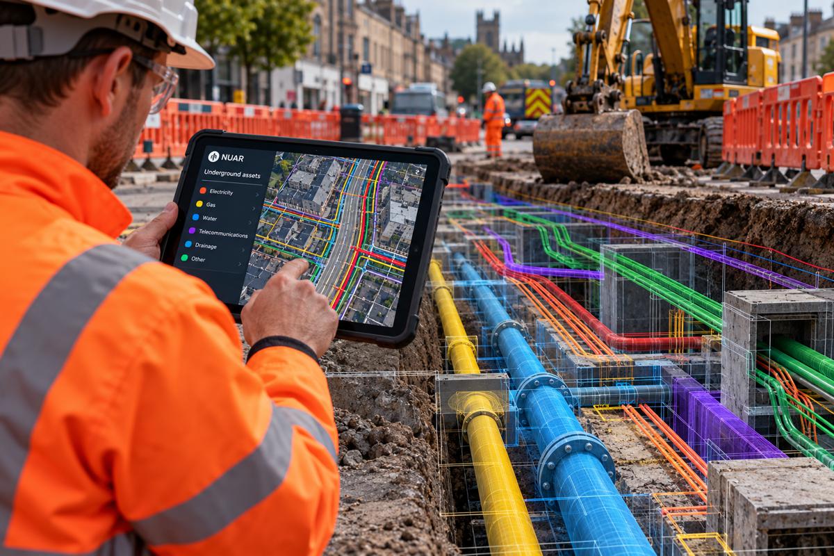
For construction and highways teams, the attraction is straightforward. Excavation planning has traditionally involved assembling utility records from different owners, often supplied separately and presented in different formats. NUAR is intended to place that information within a single secure and standardised digital environment before excavation begins.
The system is also moving beyond being a voluntary digital project. The Data (Use and Access) Act 2025 established a legislative framework for NUAR, including a requirement for the Secretary of State to maintain a register of apparatus in streets. Secondary regulations are being developed to determine how the statutory service operates, who supplies information, how it can be accessed and how its running costs are funded.
Briefing
- NUAR contains information covering more than 3.2 million kilometres of underground pipes and cables across England, Wales and Northern Ireland.
- More than 400 asset owners are contributing information, covering over 80% of known underground infrastructure in the three nations.
- Openreach contributed location information covering more than 550,000 kilometres of its network.
- NUAR recorded 10,300 end users at the end of the financial year, against an internal target of 18,000.
- The Data (Use and Access) Act 2025 provides the legislative framework for NUAR to develop into a comprehensive statutory register.
Bringing Underground Records Together
Electricity cables, water mains, sewers, gas pipes, telecommunications ducts, drainage, street-lighting supplies and other infrastructure can occupy the same highway corridor. Their records have historically remained with the organisations responsible for those assets, leaving a contractor preparing excavation work to obtain information from several organisations before the first bucket enters the ground.
NUAR does not remove the need for established safe-digging procedures, site investigation, detection equipment or professional judgement. Government guidance describes it as a digital service intended to improve the efficiency and safety of installing, maintaining, operating and repairing buried infrastructure. It provides authorised users with secure access to information supplied by asset owners rather than turning the underground environment into a perfectly surveyed digital model.
A record showing where a cable or pipe is believed to run is not the same as physically locating it on site. Historical records can contain uncertainties, infrastructure can have been altered, and the precise depth and position of buried services cannot simply be assumed from a plan.
NUAR moved out of its minimum viable product stage and into public beta in June 2025, when restrictions on the number of users within participating organisations were removed. Asset owners and their contractors could then begin considering the platform as part of their routine safe-dig processes rather than primarily as a development project.
Openreach Fills a Major Gap
Openreach added location data covering more than 550,000 kilometres of its network, including ducts, conduits, poles, spans, cabinets and chambers. Following that addition, NUAR held information on an estimated 3.25 million kilometres of infrastructure across electricity, gas, water, pipelines and telecommunications.
Coverage has continued to broaden. By September 2026, more than 400 asset owners had contributed records, all electricity Distribution Network Operators and water companies had signed up, and more than 70% of local authorities and 90% of highway authorities were sharing information. More than 230 supply-chain contractors were accessing underground asset information on behalf of asset owners.
The annual report records 10,300 NUAR end users at the end of the financial year, against an internal target of 18,000. OS attributed the shortfall to slower onboarding of asset owners, although monthly transaction volumes had exceeded 16,000 by year end. The database has acquired considerable coverage, but embedding it throughout the organisations and supply chains that excavate roads remains a work in progress.
Usage has nevertheless continued to increase, with OS reporting in September that transaction volumes had grown by 115% since it took responsibility for operating NUAR in 2025.
From Database to Working Tool
Gas distribution company SGN trialled NUAR with field teams in Oxford and Milton Keynes before moving towards a wider rollout. According to an OS case study, engineers used the platform to access underground information directly rather than relying as heavily on back-office requests for asset records. Northumbrian Water Group has similarly incorporated the platform into its safe-dig processes. These remain case studies published by the organisation operating NUAR rather than independent evaluations, but they show how the system is beginning to enter operational workflows.
For highways authorities, the information extends beyond the major utility networks. Participating councils can contribute records for drainage, street lighting, traffic signals, CCTV and EV charging infrastructure. Lincolnshire County Council has reported substantial reductions in the time required to assemble asset information when the system is fully used, although such results will depend on local data quality and existing working practices.
NUAR has also started to develop beyond the retrieval of asset records. Notification functionality introduced in January 2026 allows asset owners to see how their information is being accessed and supports notifications when proposed work is close to their infrastructure. This creates the possibility of a more direct connection between those planning excavation and the organisations whose assets may be affected.
A Statutory Register Takes Shape
The Data (Use and Access) Act 2025 inserted the legislative framework for NUAR into existing street works law. For England and Wales, it requires the Secretary of State to keep a National Underground Asset Register containing information relating to apparatus in streets, with equivalent provisions applying in Northern Ireland. The legislation provides powers covering access, information requirements, fees, enforcement and arrangements for third parties to exercise functions associated with the register.
Government has subsequently consulted on the regulations required to implement that framework. Its proposed funding model is particularly relevant to infrastructure owners: statutory apparatus information would remain free at the point of use for safe digging, while operating costs would be shared between undertakers. The legislation restricts those fees to the cost of operating the service rather than creating a profit-making mechanism for government.
There are still boundaries around the programme. NUAR currently covers England, Wales and Northern Ireland rather than the whole UK, while work continues on widening access and determining how the statutory service will interact with the existing safe-digging ecosystem.
A memorandum of understanding agreed in June 2026 between the Government Digital Service and LinesearchbeforeUdig is intended to explore integration between NUAR and established utility-search services. That approach leaves room for existing processes and services rather than assuming the new national platform will immediately replace them.
Mapping as National Data Infrastructure
NUAR forms part of a much larger change inside Ordnance Survey. Its National Geographic Database contains more than 600 million geographic features and receives around 30,000 updates each day. Roads, buildings, addresses, structures, land, water and other geographic information are increasingly maintained as interconnected data rather than conventional maps.
That infrastructure supports a business generating £198.7 million in annual revenue. Adjusted EBITDA increased from £41.8 million to £45.2 million in 2025-26, with NUAR explicitly identified in the annual report as one of the drivers of revenue growth.
The role of a national mapping service is consequently extending beyond the visible geography of roads, buildings, boundaries and terrain. Modern infrastructure management increasingly depends on connections between those features and the networks running through, underneath and around them.
For a road scheme, utility diversion, housing development or emergency repair, knowing that a street exists is only the beginning. Engineers also need to know what occupies the ground beneath it, who owns those assets and where excavation could create a problem. Britain has spent more than two centuries progressively improving its map of the surface. The harder mapping exercise now taking shape is the one beneath it.
Key Industry Questions
- What is the National Underground Asset Register? NUAR is a government digital service providing authorised users with secure, standardised access to underground asset information supplied by utilities, authorities and other infrastructure owners across England, Wales and Northern Ireland.
- How much underground infrastructure is currently represented in NUAR? More than 3.2 million kilometres of pipes and cables are represented, covering over 80% of known underground infrastructure in England, Wales and Northern Ireland.
- Does NUAR replace utility detection and safe-digging procedures? No. NUAR improves access to existing asset information but remains part of the wider safe-digging process. Contractors still need to apply appropriate site investigation, detection and excavation procedures.
- Can construction contractors access NUAR? Access has expanded to authorised contractors working on behalf of participating asset owners. By September 2026, more than 230 supply-chain contractors were accessing information through the platform.
- Is NUAR mandatory? The Data (Use and Access) Act 2025 established the legislative framework for NUAR as a statutory register. Secondary regulations are being developed to implement the detailed requirements governing information provision, access and funding.
- Does NUAR cover Scotland? No. The current NUAR service covers England, Wales and Northern Ireland.
- What information can highway authorities contribute? Depending on the authority, records can include drainage, street lighting, traffic signals, CCTV and EV charging assets alongside information from utilities and telecommunications operators.
- How current is underground asset information in NUAR? NUAR brings together information supplied and maintained by asset owners. Its usefulness therefore depends partly on the accuracy, completeness and currency of the underlying records and should not be treated as a substitute for physical verification where that is required.
Strategic Takeaways
- Bringing underground asset records into a common environment removes much of the administrative fragmentation that has traditionally preceded excavation, although it does not remove the need to verify conditions on site.
- Coverage of more than 80% of known underground infrastructure gives NUAR considerable reach, but safe excavation still depends on recognising what the register does not contain.
- Contractor access is becoming as important as asset-owner participation because much of the excavation work across the three nations is carried out through external supply chains.
- Statutory backing moves NUAR from a government technology programme towards a permanent component of street works information infrastructure.
- Integration with existing safe-dig services offers a route to wider adoption without requiring established industry workflows to be replaced immediately.