Understanding River Alteration by studying Vegetation and Geomorphology
Researchers at the Korea Institute of Civil Engineering and Building Technology published their findings on the drastic short-term alterations in rivers accompanied by shifts in vegetation and geomorphology drawn from actual on-site investigation and analyses and not from model simulations.
The alteration processes from a ‘white river,’ characterized by riverbeds with no vegetation including bare sandbars, to a densely vegetated ‘green river’ with grass and trees, have been observed in various rivers. Rivers are where continuous interactions between flowing water, vegetation, and morphology occur. The alteration arises from a combination of both natural and human factors, such as climate change and environmental change in the watershed.
The alteration can also be triggered by short-term hydrological shifts like droughts, particularly in rivers affected by the monsoon climate, characterized by abundant precipitation in summer and prevailing dry conditions in winter. The research team led by Dr. Chanjoo Lee at KICT has conducted a research project in collaboration with the Dutch research institute Deltares to analyse the characteristics of short-term river alterations found in Naeseongcheon Stream, South Korea, and interpret their causes.
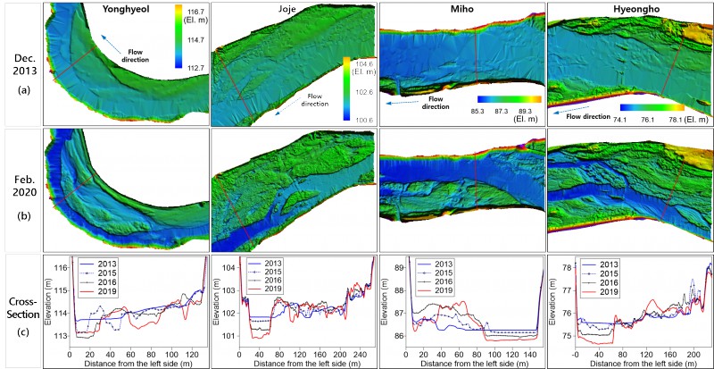
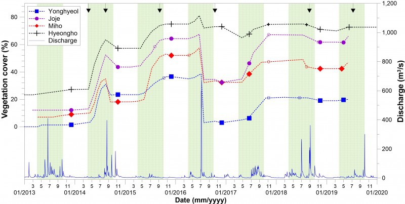
Naeseongcheon Stream, which flows through the inland areas of Gyeongsangbuk-do Province, is a dynamic sandy river with well-preserved natural features, vibrant vegetation dynamics, and active sediment transport due to hydrological fluctuations. KICT has been conducting long-term monitoring of the Naeseongcheon Stream since 2012 before significant vegetation encroachment started using light detection and ranging (or LiDAR) surveys, hydrological surveys, and vegetation mapping.
Dr. Chanjoo Lee’s research team used aerial photographs of the area from the 1990s to 2019, with LiDAR survey data gathered from 2013 for the project. The research findings revealed that Naeseongcheon Stream had experienced a gradual increase in vegetation encroachment on the riverbed since the 1990s, but the most significant surge occurred between 2014 and 2015. The sharp increase was attributed to a decrease in water flow and the absence of flooding due to a drought that affected the area during that period.
As a result, the riverbed has undergone a rapid alteration from a typical white river to a heavily vegetated green river. From the geomorphological perspective, the sand river that once flowed wide and shallow became narrow and deep, allowing the surrounding areas once covered with water and sandbars to turn into lush floodplains overgrown with vegetation.
In the joint research, KICT and Deltares identified several underlying factors contributing to the changes in Naeseongcheon Stream, including artificial factors such as water quality issues (eutrophication) that many modern rivers face, rising spring temperatures that lead to early vegetation encroachment and growth, and climate change as an over-arching driver, which causes temperature rise and fluctuations in river flow.
Shorter white river phases formed by flooding and longer green river phases dominated by abundant vegetation can be observed as sand rivers in temperate climates like Naeseongcheon Stream gradually undergo sub-topicalization caused by climate change. “Through this research, we gain insights into the interactions between hydrology, vegetation, and river morphology, which contribute to river alterations,” said Dr. Chanjoo Lee at KICT, the lead researcher of the project. “We anticipate that the research findings can be utilized in formulating river management strategies, including flood control and vegetation management.”