Esri (Environmental Systems Research Institute) is a leading global provider of geographic information system (GIS) software, location intelligence, and mapping solutions.Founded in 1969 by Jack and Laura Dangermond in Redlands, California, Esri pioneered the development of GIS technology to help organizations visualize and analyze spatial data.
Their flagship product, ArcGIS, is widely used across various industries—including government, environmental management, public health, and infrastructure—for tasks such as urban planning, disaster response, and climate change analysis.
Esri’s commitment to innovation and sustainability has made it a trusted partner for over 350,000 organizations worldwide, including 90% of Fortune 100 companies and numerous national governments.By enabling users to harness the power of location-based data, Esri plays a crucial role in addressing complex global challenges and promoting informed decision-making.
Esri and RoboGarden Expand Global Geospatial Education The global infrastructure sector is undergoing a quiet but profound transformation. From digital twins and smart highways to climate resilience p...
Esri Expands GIS Knowledge Access Through Direct Ebook Distribution Across construction, transport and infrastructure, software skills have quietly become as critical as concrete strength or asphalt m...
From Trenches to Digital Twins as Field Reality Capture Enters the Enterprise GIS Across the global infrastructure sector, the most expensive problems are often the ones nobody can see. Utilities, hig...
Esri Achieves ISO 27001 Certification for Infrastructure Data Security For governments, transport agencies and construction leaders managing critical infrastructure, data has become as valuable as con...
Automating Nautical Charts and Maritime Safety Digital Workflows The quiet digitisation of maritime chart production rarely makes headlines, yet it underpins everything from naval readiness and port c...
Esri Charting the Future with ArcGIS Maritime for Hydrographic Intelligence Esri, the global leader in geographic information system (GIS) technology, has unveiled a major leap forward in marine mappi...
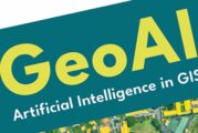
Esri’s New Book Unlocks the Power of Artificial Intelligence in GIS Esri, a global leader in geographic information system (GIS) software, has published a ground-breaking book, GeoAI: Artificial...
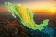
Esri MX Launches as Mexico’s New Geospatial Innovation Hub Esri, the global leader in location intelligence, has unveiled Esri Mexico (Esri MX) as its new geospatial innovation centre for the country,...
Bridging the Digital Divide in Maine with Smart Mapping and Community Outreach In the race to make the digital world more inclusive, Maine is carving out a blueprint that could serve as a model for ru...
Mapping the Future with Esri’s Powerhouse Trio of New GIS Books Esri, the global heavyweight in location intelligence, has just upped the ante with a trio of powerful new publications that blend...
Esri and Microsoft Join Forces to Usher in a New Era of AI Geospatial Intelligence In a move that’s set to shake up the landscape of geospatial technology, Esri has announced a deeper integratio...
Esri Unveils One-Click Access to Demographic Insights In a bold step towards democratising access to spatial intelligence, Esri has launched a streamlined e-commerce platform that places authoritative...
A New Era for Location-Aware Design with ArcGIS for Autodesk Forma Designing with location in mind is no longer a luxury – it’s a necessity. And in a world where urban sprawl, sustainability pressures...
Esri to Unveil AI-Powered ArcGIS Breakthroughs at GEOINT 2025 As anticipation builds for the United States Geospatial Intelligence Foundation’s GEOINT Symposium 2025, all eyes are turning to Esr...
ASCE and Esri Join Forces to Revolutionise Infrastructure Planning In a game-changing move for infrastructure planning and public policy, the American Society of Civil Engineers (ASCE) has unveiled it...
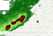
Esri and ALERTCalifornia Deliver Real-Time Disaster Monitoring in ArcGIS In a bold move to strengthen California’s disaster readiness, Esri has teamed up with the University of California San Di...
Esri’s New Tool Paving the Way for Real-Time Road Closure Mapping Navigating city streets can be a frustrating experience when unexpected road closures disrupt journeys, turning straightforward...
Mastering Mobile GIS with Esri’s Latest Guide to the Rapidly Evolving Field In today’s fast-paced digital landscape, the terms “mobile first” and the “post-PC era”...
Esri Unveils Content Store for ArcGIS to Revolutionise Geospatial Data In a significant stride towards enhancing geospatial data accessibility, Esri, the global leader in location intelligence, has un...
Esri Developer and Technology Summit Elevating Geospatial Innovation The Esri Developer & Technology Summit, now in its 20th year, is set to take centre stage in Palm Springs, California, from Mar...
TomTom and Esri Join Forces for Advanced Location Analytics In an era where location intelligence is pivotal to decision-making, the partnership between TomTom and Esri has set the stage for transform...
Unlocking the Power of Geographic Information Systems Geographic Information Systems (GIS) have revolutionised the way we plan, build, and manage infrastructure. On this GIS Day, Highways.Today explor...
How Spatial Data Science Is Revolutionising Data-Driven Decision-Making Spatial data science, the art and science of interpreting geographic information, is rapidly reshaping industries. From urban pl...
Esri and Autodesk Revolutionise AECO Planning In an industry where precision and context are everything, Esri, the leader in Geographic Information Systems (GIS) technology, and Autodesk, a major forc...
Esri releases Third Edition of the beloved Designing Better Maps Guide When it comes to making maps that aren’t just functional but also a pleasure to behold, Esri knows a thing or two—or maybe...
Samsara and Esri supercharge Public Sector Fleet Operations with Real-Time Integration In the fast-paced world of public sector fleet operations, efficiency and accuracy are more critical than ever. E...
Esri releases new books on Geospatial, Mapping and GIS Python Technologies Geospatial technology is no longer just the domain of cartographers and data scientists—it’s now a transformative force...
Using GIS to make Highways Safer and tackle Truck Blow-Over Crashes In the windswept plains of Wyoming, where the skies stretch endlessly and the weather can shift in an instant, the state’s three maj...
Esri ArcGIS Online secures FedRAMP Moderate Authorization In an era where data security is paramount, especially within government operations, Esri’s latest achievement is a significant milestone. The...
Celebrating Mapping and 25 years of GIS Day On November 20, 2024, the world will come together to celebrate the 25th anniversary of GIS Day, a global event that highlights the power of Geographic Info...
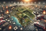
Harnessing Data and Technology for Wildfire Mitigation Wildfires have become an increasing menace, raging with greater frequency and intensity across the globe. Understanding and managing wildland-urb...
Esri’s announces new book for newbies to learn ArcGIS Online Esri, the global leader in location intelligence, today announced the publication of Top 20 Essential Skills for ArcGIS Online, a ste...
Esri announces new edition of ArcGIS Pro Book Esri, the global leader in location intelligence, today announced the publication of Getting to Know ArcGIS Pro 3.2. The newest edition of this comprehens...
Revolutionising Spatial Analytics with Esri, Microsoft and IBM In a significant leap forward, Esri has announced a deepened collaboration with Microsoft, seamlessly integrating its powerful spatial an...
Esri ArcGIS Basemaps now integrated into Autodesk Civil 3D and AutoCAD Industry leaders in the architecture, engineering, and construction (AEC) sectors are increasingly relying on the interoperabilit...
ArcGIS upgrades help to efficiently and securely build solutions In 2021, Esri, the global leader in location intelligence, released ArcGIS Platform, a geospatial platform as a service (PaaS) for deve...
National Geographic MapMaker launched by Esri and National Geographic Society By learning about mapping skills and geography, students, teachers, and others can gain a better understanding of how the...
Esri now integrates with Microsoft Fabric adding Spatial Analytics To meet the growing demand for spatial analytics, Esri is extending its long-standing strategic collaboration with Microsoft through...
Esri ArcGIS Basemaps and ArcGIS Living Atlas to be integrated with Autodesk Digital transformation is rapidly changing the foundational processes powering the architecture, engineering, and constructi...
National Highways wins Esri Special Achievement in GIS Award National Highways has been announced as the only UK winner of an Esri Special Achievement in GIS Award, having won the accolade for its inn...
Esri enhances 3D GIS Workflows by integrating 3D Tiles into ArcGIS Organizations in national, state, and local governments; architecture, engineering, and construction (AEC) sectors; and more are impl...
Winners of the Esri 2023 ArcGIS Online Competition announced Students across the nation learn about environmental and social concerns every day not just in the classroom, but from the communities in w...
Esri to provide Malta with GIS Technology and Training In 1990, the government of Malta formed the Malta Information Technology Agency (MITA) with a mission to manage the implementation of public IT p...
Esri’s new ArcGIS Reality Software captures the World in 3D Business, government, and science organizations increasingly rely on drones, crewed aircraft, and satellites to capture imagery. Detai...
Esri joins Overture Maps Foundation to build Interoperable Open Map Data In an increasingly digital and automated world, geospatial data plays a critical role in understanding the physical environment...
Baron Weather empowering the Esri Partner Network with Weather Intelligence Baron Weather, Inc., the world leader in superior weather intelligence joins the Esri Partner Network (EPN) with packages th...
Exodigo and Esri partner to Improve Underground Mapping Exodigo, the breakthrough non-invasive subsurface imaging platform, announced a partnership today with Esri, the world leader in Geographic Info...
Esri and Digital Earth Africa partner to support Sustainable Growth Climate change is compounding risks of food insecurity, displacement, and natural disasters across broad regions of the African cont...
Esri initiative offers free Geospatial Software to Non-profits Non-profits are increasingly taking a geographic approach to implementing their plans and ensuring the success of their goals. One non-pr...
Esri releases latest edition of Online GIS Capabilities book From magnetic tapes to cloud computing, technology has advanced greatly over the 50-plus-year history of geographic information system (GIS...
BlackSky partners with Esri for Dynamic Satellite Tasking for ArcGIS BlackSky Technology and Esri have developed an integration that gives Esri’s global customer base access to BlackSky’s dynamic task...
Esri announces free Online Course on Geospatial Software for AEC Projects Recently, there has been strong demand for investment in architecture, engineering, and construction (AEC) projects with incre...
Esri launches Indoor Positioning Navigation System Smartphone navigation apps have given people a greater sense of personal freedom, allowing them to efficiently venture from one unfamiliar place to a...
Italian Rail Agency recognised by ESRI for Modernizing Infrastructure Last year, the Italian rail agency Rete Ferroviaria Italiana (RFI) built an application using geographic information system (GIS)...
Esri StoryMaps brings sophisticated Mapping Technology to Storytelling Capturing and sharing life’s experiences today often requires multiple platforms and tools, which can result in disjointed...
Esri UK annual GIS conference returns to QEII Centre in London Esri UK has announced the full programme for its upcoming annual conference and exhibition on 17 May 2022, including speakers from Arcadi...
Esri updates Land-Cover Maps with new global datasets Governments and businesses across the world are pledging to adopt more sustainable and equitable practices. Many are also working to limit activit...
Esri’s new book helps Public Safety Agencies get started with GIS Technology When a winter storm battered a major city in the southwestern US and left millions in the community without power or...
Esri releases guides for Location Analytics and Improving Map Aesthetics Getting to Know ArcGIS Pro 2.8 It’s never been easier to get data, but for many organizations it is still challenging to...
Esri and WorldPop delivering updated Demographic Data for Policy Makers The global population grew by almost two billion people during the last 20 years—nearly 30 percent. Such growth is not evenly di...
This website uses cookies to improve your experience while you navigate through the website. Out of these, the cookies that are categorized as necessary are stored on your browser as they are essential for the working of basic functionalities of the website. We also use third-party cookies that help us analyze and understand how you use this website. These cookies will be stored in your browser only with your consent. You also have the option to opt-out of these cookies. But opting out of some of these cookies may affect your browsing experience.
Necessary cookies are absolutely essential for the website to function properly. These cookies ensure basic functionalities and security features of the website, anonymously.
Cookie
Duration
Description
cookielawinfo-checkbox-analytics
11 months
This cookie is set by GDPR Cookie Consent plugin. The cookie is used to store the user consent for the cookies in the category "Analytics".
cookielawinfo-checkbox-functional
11 months
The cookie is set by GDPR cookie consent to record the user consent for the cookies in the category "Functional".
cookielawinfo-checkbox-necessary
11 months
This cookie is set by GDPR Cookie Consent plugin. The cookies is used to store the user consent for the cookies in the category "Necessary".
cookielawinfo-checkbox-others
11 months
This cookie is set by GDPR Cookie Consent plugin. The cookie is used to store the user consent for the cookies in the category "Other.
cookielawinfo-checkbox-performance
11 months
This cookie is set by GDPR Cookie Consent plugin. The cookie is used to store the user consent for the cookies in the category "Performance".
viewed_cookie_policy
11 months
The cookie is set by the GDPR Cookie Consent plugin and is used to store whether or not user has consented to the use of cookies. It does not store any personal data.
Functional cookies help to perform certain functionalities like sharing the content of the website on social media platforms, collect feedbacks, and other third-party features.
Performance cookies are used to understand and analyze the key performance indexes of the website which helps in delivering a better user experience for the visitors.
Analytical cookies are used to understand how visitors interact with the website. These cookies help provide information on metrics the number of visitors, bounce rate, traffic source, etc.
Advertisement cookies are used to provide visitors with relevant ads and marketing campaigns. These cookies track visitors across websites and collect information to provide customized ads.