Exploring GeoAI Shows Why Spatial Intelligence is Becoming Core Infrastructure
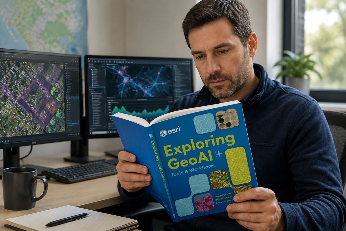
Esri’s release of Exploring GeoAI: Tools and Workflows looks, on the surface, like a routine entry in a technical publisher’s catalogue: a US$39.99 workbook of step-by-step tutorials for building deep learning models inside ArcGIS. Read against the state of the wider market, it is a more pointed move than the price tag suggests.
The binding constraint on geospatial AI adoption has quietly shifted over the past two years. It is no longer the availability of models, which Esri already distributes by the hundred, but the availability of professionals who can prepare the data, choose the right model, evaluate its output and put the result into operational use. A modest publication, in other words, has been aimed squarely at the most expensive problem in the sector.
That problem carries a substantial commercial weight. The geospatial intelligence market was valued at roughly USD 37 billion in 2025 and is forecast to reach almost USD 63 billion by 2030, a compound annual growth rate above eleven per cent, with artificial intelligence and machine learning applied to satellite, drone and sensor data cited as the principal driver.
The same body of research that tracks this demand also identifies a shortage of skilled practitioners as a structural brake on growth rather than a passing inconvenience. For infrastructure owners, surveyors and asset managers, the practical question has moved on from whether GeoAI works to who inside the organisation can run it reliably. A workbook does not answer that on its own, yet it marks precisely where Esri now believes the expansion of its platform is gated.
Briefing
- Esri has published Exploring GeoAI: Tools and Workflows, a hands-on ArcGIS workbook by Ismael Chivite, Nicholas Giner and Craig Carpenter, available in paperback and ebook at US$39.99 through Ingram Publisher Services and major online retailers.
- The book is the practical companion to Esri’s 2025 conceptual primer GeoAI: Artificial Intelligence in GIS, signalling a shift in emphasis from explaining why GeoAI matters to teaching how to operationalise it.
- Industry research points to a widening workforce bottleneck, with demand for geospatial talent in North America reported to be growing close to five times faster than the number of qualified graduates entering the field.
- ArcGIS now offers more than one hundred ready-to-use pretrained deep learning models through the Living Atlas, covering tasks from building footprint and road extraction to lidar point cloud classification of powerlines, poles and trees.
- The workbook lands as Esri advances a three-tier artificial intelligence strategy spanning tools and models, embedded assistants and, most significantly, agentic AI capable of running multi-step geospatial workflows.
Why a Talent Shortage Is the Commercial Story
The skills deficit in geospatial work is now well documented and unusually acute. Research presented at Geo Week 2026 in Denver by Dr Shawana Johnson of Global Marketing Insights concluded that demand for geospatial talent across North America is expanding at nearly five times the rate at which qualified graduates enter the profession.
Her assessment of the underlying capability gap was blunt, describing a workforce that is 10 to 15 years behind where employers need it to be in terms of skills, with artificial intelligence sitting at the centre of the shortfall. This is not a cyclical hiring squeeze that will ease with the next graduating cohort. It is a mismatch between the competencies employers require and those the education pipeline is producing, and it is being felt across commercial, defence, infrastructure and development sectors at the same time.
The wider labour data reinforces the point. ManpowerGroup’s 2026 talent shortage survey, covering tens of thousands of employers across more than forty countries, found that roughly seven in ten struggle to find candidates with the skills they need, and geospatial employers report the problem in sharper terms than most. Job listings that once asked for map-making now demand Python fluency, machine learning literacy and the ability to automate spatial workflows, and the pay premium attached to those hybrid skills tells its own story about scarcity.
For a vendor whose revenue depends on organisations extracting value from its software, a shortage of people able to do exactly that is a direct commercial threat. Teaching the workflow is therefore not corporate philanthropy. It is a rational response to the fact that unused capability generates no renewals.
From Pretrained Models to Working Infrastructure
The reason the skills gap has become the decisive variable is that the technical barrier has already fallen a long way. ArcGIS users can now draw on more than one hundred pretrained deep learning models hosted in the Living Atlas, covering building footprint extraction, road extraction, solar panel and swimming pool detection, land cover classification, change detection and the classification of lidar point clouds.
These models are designed, in Esri’s own framing, to remove the need for vast training datasets, heavy compute and deep artificial intelligence expertise. The effect is to shift the work from building models to applying, validating and maintaining them, which is a very different set of skills and one the new workbook sets out to teach.
The infrastructure relevance is concrete rather than theoretical. Larsen and Toubro, one of the largest engineering and construction groups in Asia, has used Esri’s pretrained models to extract railway assets from lidar data, the kind of asset inventory task that underpins maintenance planning and safety compliance across a rail network. Kuwait’s Public Authority for Civil Information has applied road extraction at national scale as part of an infrastructure programme oriented towards 2035.
Point cloud classification in ArcGIS relies on established deep learning architectures such as RandLANet, SQN and PointCNN, and produces compact, shareable model packages that can be reused across projects. For asset owners, the significance lies in the lifecycle economics. Automated feature extraction from lidar and imagery compresses the cost of building and refreshing the digital record of a highway, rail corridor or utility network, and a current, accurate asset base is the foundation on which condition monitoring, risk assessment and capital planning all depend.
Why the Market Leader Is the One Teaching the Workflow
Esri’s decision to invest in workforce enablement is best understood through its market position. Founded in 1969 and still privately held, the Redlands company has never taken outside capital, reinvests a large share of revenue into research and development, and commands the largest share of the global GIS software market, estimated by some analysts at around a third and by others higher, across a base of more than 700,000 customer organisations.
That combination of dominance and self-funding gives Esri both the incentive and the freedom to shape the market it leads. When the constraint on further platform adoption is the supply of capable users, the most effective growth investment may be education rather than another feature release.
The publishing strategy makes this explicit. The 2025 title GeoAI: Artificial Intelligence in GIS, which Highways.Today covered on release, was a primer built around case studies and a technology showcase, framed by Esri president Jack Dangermond’s description of GeoAI as the integration of spatial analysis, AI, and big data.
Exploring GeoAI: Tools and Workflows moves deliberately from that conceptual register into procedure, walking readers through installing frameworks, checking hardware, defining project requirements, selecting data, training and evaluating models and deploying them. The progression from why to how mirrors the maturing of the market itself. It also quietly deepens the platform’s competitive moat, because a workforce trained in ArcGIS workflows represents switching costs that rivals such as Bentley Systems, Hexagon, Trimble and the open-source QGIS community cannot easily erode.
The Agentic Shift and Where Value Moves Next
The workbook arrives at an inflection point in Esri’s own artificial intelligence roadmap, and that timing matters for how its value should be read. Esri now frames its AI work across three tiers. The first is tools and models, the pretrained deep learning capabilities the book teaches. The second is AI assistants, natural-language helpers now embedded across ArcGIS, with the Survey123, Business Analyst and translation assistants reaching general availability in mid-2026 and further assistants for Notebooks, ArcGIS Pro and Arcade in preview.
The third, and the one drawing the most strategic interest, is agentic AI: autonomous systems that reason over spatial and non-spatial data to carry out multi-step workflows, positioning ArcGIS as a spatial layer that any enterprise AI agent can call on demand. These themes dominated the 2026 Esri User Conference in San Diego, which drew more than 18,000 attendees under the banner of creating a more intelligent world.
That roadmap raises a fair question about the durability of a hands-on tutorial, and the answer is where the real editorial insight sits. As assistants and agents lower the barrier to running spatial analysis, the routine mechanics of model execution will increasingly be automated. What does not automate is judgement. Someone still has to decide whether a lidar model trained on one geography is valid for another, whether a road-extraction output is accurate enough to feed a maintenance schedule, and whether an agent’s confident answer is actually correct.
Esri’s own materials stress that users remain in control of their workflows, and the enduring professional value is shifting from producing GeoAI outputs to specifying, supervising and validating them. A workbook that builds fluency in data preparation, model selection and evaluation is, on this reading, training the exact judgement layer that agentic tooling will make more valuable, not less.
What Infrastructure Owners Should Take From It
For the organisations that build and maintain physical infrastructure, the practical implications are less about buying a book and more about workforce and procurement strategy. The competitive advantage in the next cycle of asset management will not accrue to whoever licenses the most capable GeoAI software, since capability is becoming widely available and increasingly commoditised through pretrained models. It will accrue to the operators who can absorb that capability into working practice, verify its outputs and integrate them with engineering decisions.
That points toward investment in internal training and toward managed-service arrangements, which the market is already turning to as a way around the talent shortage, rather than assuming a hiring market that cannot currently supply the people.
There is also a procurement signal worth reading in the broader landscape. Bentley Systems continues to build its position around infrastructure digital twins, Trimble and Topcon around field capture and surveying, and Esri around the analytical and asset-management layer that connects them. GeoAI is becoming the connective tissue that turns raw survey and sensor data into decision-ready information across that stack.
Infrastructure owners specifying platforms and framework agreements will increasingly need to weigh not just software features but the depth of the talent and training ecosystem behind each vendor, because the tool is only as valuable as the workforce able to wield it. On that measure, Esri’s decision to publish the workflow, rather than merely sell the software, is a competitive position in its own right, and one that quietly reframes a US$39.99 workbook as an instrument of platform strategy.
Key Industry Questions
- What is GeoAI and how does it differ from traditional GIS? GeoAI is the application of artificial intelligence, particularly machine learning and deep learning, to geospatial data and analysis. Traditional GIS focuses on storing, mapping and manually analysing location data, whereas GeoAI automates feature extraction, classification and prediction at a scale and speed that manual methods cannot match. In practice this means training or applying models that can identify buildings, roads, powerlines or trees from imagery and lidar, detect change over time, and generate predictive spatial insight. The distinction matters commercially because GeoAI turns geospatial analysis from a labour-intensive craft into a partly automated pipeline, which changes both the cost base and the skills required to run it.
- Why does a US$39.99 workbook matter to the infrastructure sector? The book itself is a small artefact, but it addresses the sector’s most binding constraint. Infrastructure owners increasingly hold vast volumes of lidar, imagery and sensor data, and the value of that data depends on having staff who can process it into reliable asset information. With qualified geospatial talent in short supply, structured training that builds practical GeoAI competency directly affects an organisation’s ability to modernise asset management, condition monitoring and capital planning. The workbook is best read as a signal of where capability, and therefore competitive advantage, is now concentrated, rather than as a product of interest only to individual analysts.
- How significant is the geospatial skills shortage? It is significant and structural rather than cyclical. Research presented in 2026 indicated that demand for geospatial talent in North America is growing at close to five times the rate of qualified graduates entering the field, and that the existing workforce is a decade or more behind on the AI-related skills employers now require. Broader labour surveys show around seven in ten employers globally struggling to fill skilled roles. For infrastructure and construction organisations, the shortage translates into slower adoption, higher recruitment costs and greater reliance on external managed services to close the gap.
- What can ArcGIS pretrained models actually do for asset owners? ArcGIS offers more than one hundred pretrained deep learning models that can extract and classify features from imagery and lidar without the user having to build a model from scratch. For asset owners, the relevant applications include extracting road networks, identifying building footprints, classifying powerlines and poles, and separating vegetation from structures in point cloud data. Real deployments include railway asset extraction from lidar and national-scale road extraction. The commercial benefit is a sharp reduction in the time and cost of building and maintaining an accurate digital asset inventory, which underpins maintenance, safety and investment decisions.
- Does agentic AI make hands-on GeoAI training redundant? No, and arguably the opposite. Agentic AI automates the execution of multi-step workflows, which reduces the manual effort of running analysis, but it does not remove the need for professional judgement. Practitioners still have to validate whether outputs are accurate, whether a model is appropriate for a given dataset and geography, and whether an automated recommendation can be trusted in an engineering or safety context. Training that builds fluency in data preparation, model selection and evaluation develops exactly the supervisory judgement that becomes more important as more of the mechanical work is automated.
- How does GeoAI affect procurement decisions for infrastructure platforms? GeoAI shifts the basis of platform evaluation. As core AI capabilities become more widely available and partly commoditised through pretrained models, differentiation moves toward the surrounding ecosystem, including the depth of training resources, the availability of skilled practitioners and the ease of integrating outputs with engineering workflows. Buyers specifying framework agreements should weigh vendor lock-in, total cost of ownership and the strength of each supplier’s talent and training pipeline alongside technical features. The vendor with the strongest workforce ecosystem may deliver more realised value than the one with the most advanced but underused software.
- Where does Esri sit relative to competitors in this space? Esri is the long-standing market leader in GIS software, with the largest share of the global market and a base exceeding 700,000 customer organisations. It competes with Bentley Systems, which is strong in infrastructure digital twins, Hexagon and Trimble in measurement and field capture, Autodesk at the design boundary, and the open-source QGIS community on cost. Esri’s differentiation increasingly rests on the breadth of its platform and its investment in the surrounding education and workforce ecosystem, of which the new workbook is one part. Its self-funded status and high reinvestment in research and development support a long-term platform strategy rather than short-term feature competition.
- What should organisations do now to prepare for GeoAI adoption? Organisations should treat workforce capability as the priority rather than assuming software procurement is sufficient. That means investing in structured training for existing staff, building internal fluency in spatial data science and Python-based automation, and using managed-service arrangements where the talent market cannot supply the required skills. It also means auditing the quality and currency of existing geospatial data, since GeoAI outputs are only as good as the inputs. Early, deliberate investment in people and data foundations positions an organisation to capture value as the technology matures toward assistant-driven and agentic workflows.
Strategic Takeaways
- The decisive constraint on GeoAI value has moved from model availability to workforce capability, making training and talent strategy, rather than software features, the primary lever for organisations seeking returns from geospatial AI.
- Pretrained models and forthcoming agentic tooling are commoditising the technical execution of GeoAI, which means durable competitive advantage will accrue to organisations that can validate, supervise and integrate outputs into engineering and asset decisions.
- Automated feature extraction from lidar and imagery materially lowers the lifecycle cost of building and maintaining digital asset inventories, strengthening the business case for GeoAI in highways, rail and utility asset management.
- Esri’s move from a conceptual GeoAI primer to a hands-on workflow guide reflects a maturing market and quietly reinforces platform lock-in, since a workforce trained in ArcGIS represents switching costs competitors cannot easily displace.
- Infrastructure buyers should weigh the depth of each vendor’s training and talent ecosystem alongside technical capability when specifying platforms, because underused software delivers little value regardless of how advanced it is.