Pasig River Digital Twin Builds a Shared Picture of Plastic Pollution
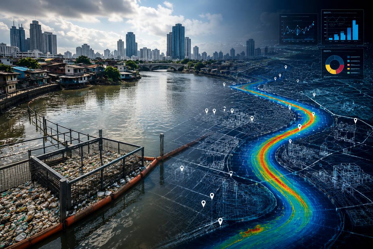
The Pasig River is only 27 kilometres long, yet it is estimated to carry around 63,000 tonnes of plastic into the ocean each year. Across Metro Manila, more than 48 tributaries feed into a waterway affected by dense development, stormwater runoff, tidal movements, inadequate waste services and an enormous volume of discarded material.
Cleaning it is considerably more complicated than collecting rubbish from the water. A digital twin developed through an Asian Development Bank initiative is attempting to give the government agencies responsible for the river something they have historically lacked: a common technical picture of where plastic originates, how it moves through the river system, where it accumulates and where interventions are most likely to work.
The work was detailed by Christine Po King Chan, Principal Urban Development Specialist at the Asian Development Bank; Rudolph Peralta, Digital Automation Leader at Arup Manila; and Christian Rieza, Knowledge Management Specialist at ADB, in a Development Asia article examining how digital twins can support the management of urban river pollution. Their account describes a six-month proof of concept bringing hydrology, satellite imagery, infrastructure records, waste surveys, artificial intelligence and government datasets into a shared digital environment.
The technology is interesting, but the more difficult engineering problem lies behind it. The Pasig is managed by numerous organisations operating across different jurisdictions and maintaining information for different purposes. A river, meanwhile, pays little attention to administrative boundaries.
Briefing
- The 27-kilometre Pasig River is estimated to carry around 63,000 tonnes of plastic into the ocean annually.
- More than 48 tributaries feed the river system across densely developed Metro Manila.
- The digital twin combines hydrological modelling, satellite imagery, infrastructure information, waste surveys and government datasets.
- More than 40 datasets are publicly accessible through the platform, with around 200 additional datasets under development.
- An AI plastic-detection system achieved early testing accuracy of 60% to 70% and can classify rigid plastic, flexible film and foam.
A River Spread Across Government
Plastic entering the Pasig does not have a single source. Rain can wash waste from streets and markets into drains and tributaries. Material enters esteros from settlements and commercial areas, while illegal dumping and industrial discharges add further pathways. Tidal conditions complicate matters because flows can reverse seasonally, moving floating material through tributaries before carrying it back towards Laguna de Bay.
Responsibility is similarly distributed. The Department of Environment and Natural Resources tracks interventions in esteros and manages trash traps. The Metropolitan Manila Development Authority operates clean-up activities and pumping stations. The Philippine Atmospheric, Geophysical and Astronomical Services Administration maintains rainfall and water-level information, while local authorities hold their own waste-management records.
These organisations already coordinate their work. DENR participates with local governments in solid waste planning, monitoring and circular-economy programmes, while its Environmental Management Bureau has installed nearly 200 trash traps across Metro Manila. National measures include the Ecological Solid Waste Management Act, the Extended Producer Responsibility Act of 2022 and the National Plan of Action on Marine Litter, which targets zero waste entering Philippine waters by 2040.
What has been missing is the ability to examine much of this information together. A rainfall record held by one organisation, a water-level measurement maintained by another and information about a waste trap managed somewhere else may all describe different parts of the same physical event. Integrating them allows the river to be examined as a system rather than as a collection of administrative responsibilities.
Building the Digital River
The Pasig River prototype is built on TerriaJS, an open-source platform designed to bring geospatial information from multiple sources into a common environment. Agencies can contribute information through tiered access arrangements without surrendering control of the underlying data.
More than 40 datasets are already available publicly, with roughly 200 additional datasets in development. Information can be viewed in two, three and four dimensions, while live feeds include rainfall and water-level data.
Hydraulic modelling adds another layer. Rainfall and tidal conditions are used to predict river discharge and water levels, producing velocity maps that can help identify where floating waste is likely to travel. Satellite observations can provide information on turbidity, debris and areas of plastic accumulation.
A location that appears suitable for a trash trap, for example, can be examined against predicted water velocity and other river conditions. Faster water may carry more plastic through a particular channel, but the same current could make a collection structure vulnerable to damage. The project authors note that future work needs to consider the hydraulic conditions and physical design of traps together.
ADB launched the Pasig River Plastic Waste Discovery Space in November 2024, envisaging a virtual environment in which interventions could be modelled before implementation. Arup and RiverRecycle were subsequently selected through the challenge, with Arup working alongside ADB and government partners on the digital twin prototype.
The development programme allocated US$300,000 for teams to develop plastic-waste models during a six-month period from January to June 2025. Proposals were assessed principally on technical soundness and feasibility, alongside expertise, deliverability and stakeholder engagement.
Watching Plastic Move
Time-lapse cameras positioned along tributaries collected footage of material moving through the waterways. Thousands of images were manually tagged to train a computer-vision model capable of recognising rigid plastics, flexible films and foam, as well as estimating the speed and direction in which debris is travelling.
At Buhangin Creek, a tributary within the San Juan River system, analysis of a one-month camera survey identified more than 300,000 pieces of plastic. More than half were film plastics, single-use materials and foam. Early testing of the detection model achieved accuracy of between 60% and 70%, leaving considerable scope for refinement before automated classification could be regarded as definitive.
Repeated observations can nevertheless begin to establish where waste is appearing, what type of material dominates particular locations and how movement changes with river conditions. The Plastic Waste Module has also been designed for people outside specialist data teams, allowing city officials and barangay waste collectors to upload footage and generate classified reports.
A proposed next stage would connect these observations with the hydrology and hydraulic models. Instead of recording plastic only after it appears at a monitoring point, the platform could begin estimating where material is likely to accumulate under particular combinations of rainfall, river discharge and tidal conditions, giving collection teams an opportunity to intervene earlier.
Following the Leakage Pathways
The prototype has already provided a more detailed picture of the waste entering the system. Estero de Tutuban recorded the highest proportion of plastic among sampled locations, accounting for approximately 53% of the waste, while investigations identified four principal leakage pathways: urban stormwater runoff, discharge from street sweeping, illegal dumping into esteros and industrial wastewater discharge.
Single-use plastics, particularly sachets used for everyday consumer products, were prominent in the waste stream. A trash trap can intercept floating material, but it cannot change the packaging entering the waste stream or prevent rubbish being discarded into an upstream drainage channel.
The platform allows physical infrastructure to be considered alongside waste collection, enforcement and upstream interventions. Hydraulic modelling can help assess where interception equipment might work; waste classification can indicate what it would collect; geographic information can help trace likely sources.
Community evidence adds another layer. In surveys cited by the project team, 90% of residents regarded garbage as a serious problem and 75% described nearby esteros as dirty. Digital infrastructure can help decide where to act, but somebody still has to collect the waste, maintain the drainage system, enforce regulations and provide functioning municipal services.
The Hard Part of Digital Twins
Much of the discussion around infrastructure digital twins concentrates on sensors, models, visualisation and computing. Pasig demonstrates how quickly institutional questions emerge once a twin crosses organisational boundaries.
More than 18 government agencies participated in defining, designing and developing the platform. That required decisions about who could see information, how it would be stored, how sources would be attributed and whether contributing an agency dataset meant losing control of it. Tiered access, formal data-sharing arrangements and defined responsibilities were incorporated into the system.
The project began with the decisions agencies needed to make rather than attempting to assemble every dataset that could conceivably be collected. An open-source, modular system also allowed a relatively lightweight prototype to be developed first rather than committing immediately to a large proprietary platform. At the end of the six-month proof of concept, the codebase was handed to DENR for hosting, further development and possible scaling.
Earlier ADB material described the intended outcome as digital public infrastructure capable of supporting longer-term urban and environmental management. The project architecture was designed so that additional analytics could subsequently be layered onto the underlying data environment.
From Prototype to Infrastructure
The longer-term test will be whether the prototype becomes part of everyday government decision-making. A technically sophisticated model that is not maintained, trusted or used will achieve little, while a comparatively modest shared platform embedded in planning and operations has a much better chance of surviving beyond the demonstration phase.
That makes the Pasig project a useful model for other cities considering digital twins for environmental infrastructure. Starting with a limited operational problem allows governments to establish whether agencies can share data, whether models provide useful answers and whether the platform fits the decisions people actually have to make before attempting something considerably larger.
ADB’s own recommendations from the project follow much the same approach: begin with a “digital twin lite”, put data governance ahead of technological ambition, build institutional readiness gradually and use modular architecture that can be adapted to different waterways and cities.
The river itself supplies the integration problem. Rainfall, drainage, tides, waste, infrastructure and human activity interact continuously, regardless of which authority is responsible for each component.
A useful digital twin has to do the same.
Key Industry Questions
- What is the Pasig River Digital Twin? It is an open-source digital platform combining geospatial information, hydrological modelling, satellite observations, infrastructure information and plastic-waste data to create a shared representation of the Pasig River system.
- Who developed the prototype? The initiative was led by the Asian Development Bank with government partners. Arup and RiverRecycle were selected through ADB’s Pasig River Plastic Waste Discovery Space, with Arup working with ADB on the prototype.
- How much plastic does the Pasig River carry? The figure cited by the project authors is approximately 63,000 tonnes of plastic entering the ocean annually from the Pasig River system.
- How is artificial intelligence being used? Computer vision analyses camera footage to identify rigid plastics, flexible film and foam and estimate the movement of floating debris. Early testing reported classification accuracy of 60% to 70%.
- Can the system predict where plastic will accumulate? Hydraulic modelling already provides information about river flows and potential waste movement. A future phase is intended to combine plastic detection with hydrological and hydraulic modelling to improve predictions of accumulation locations.
- Why use an open-source platform? The TerriaJS architecture allows different datasets and analytical tools to be integrated without tying the system to a single proprietary platform. The codebase has been transferred to DENR for future hosting and development.
- Does the digital twin replace physical river cleanup? No. It is intended to improve the information used to target collection, infrastructure, enforcement and upstream waste-management measures. Physical intervention remains necessary.
- Could the approach be replicated elsewhere? The architecture was deliberately developed as a modular system. ADB recommends beginning with a relatively small digital twin prototype before expanding it as institutional and technical capability develops.
Strategic Takeaways
- Shared data architecture may be as important as sophisticated modelling when a digital twin spans several government organisations.
- Hydraulic modelling can improve the siting of waste interception infrastructure, but flow velocity and structural survivability need to be assessed together.
- Computer vision does not need to achieve perfect classification before repeated observations begin revealing useful waste patterns.
- Open-source architecture can reduce dependency on a single technology supplier and make subsequent government ownership easier.
- Beginning with a defined operational problem provides a practical route into digital twins without requiring an entire city or infrastructure system to be digitised first.