Reading the Ocean from Space in Three Dimensions
For most of the satellite era, ocean observation has been surprisingly shallow. Scientists became remarkably good at measuring what was happening across the surface of the sea, mapping chlorophyll concentrations, identifying algal activity, tracking sediment movement and building global records of changing marine conditions. Those advances transformed climate science, marine ecology and environmental management, yet the reality beneath the waves remained largely hidden.
That limitation has become increasingly difficult to ignore. The ocean is not a flat surface but a layered and constantly changing environment where light, biology, temperature and underwater geography interact. Ports depend on understanding seabed conditions. Coastal authorities need better insight into changing shorelines. Shipping routes are influenced by dynamic ocean processes, while infrastructure investors increasingly rely on marine intelligence as offshore construction, energy generation and climate adaptation projects expand. Traditional ocean-colour satellites offered broad coverage, but they generally measured integrated signals from the upper water column rather than resolving what was happening vertically.
A growing body of research now suggests that space-based observation may be entering a different phase altogether. Scientists are beginning to combine active sensing, machine learning and multisensor data fusion to move from two-dimensional ocean maps toward a more complete representation of the marine environment. At the centre of this shift sits a mission that was never originally designed to become an ocean science platform.
Briefing
- ICESat-2 is enabling researchers to observe vertical ocean structure rather than relying solely on surface measurements.
- The ATLAS photon-counting lidar system can retrieve shallow-water bathymetry and water-column properties from orbit.
- Machine learning and advanced correction methods are improving the extraction of useful marine signals.
- Combining ICESat-2 with optical satellites and in situ measurements is accelerating ocean intelligence capabilities.
- Long-term development points toward operational three-dimensional and eventually four-dimensional ocean observation.
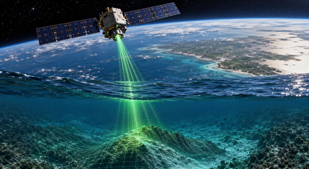
An Ice Mission That Found a Second Life at Sea
When NASA launched ICESat-2 in 2018, expectations centred on polar research. The mission was designed primarily to monitor changes in ice sheets, sea ice thickness and global elevation with unprecedented precision. Ocean observation was not expected to become one of its defining contributions.
That changed because of one important technical characteristic. ICESat-2 carries the Advanced Topographic Laser Altimeter System, known as ATLAS, which differs fundamentally from passive imaging satellites. Rather than recording reflected sunlight, ATLAS actively emits laser pulses and measures returning photons. Operating at a wavelength of 532 nanometres, within the green portion of the spectrum, the system can penetrate water under suitable conditions and capture information below the ocean surface.
The engineering behind this capability is significant. ATLAS fires approximately 10,000 laser pulses every second and generates exceptionally dense sampling with along-track measurements approaching roughly 0.7 metres together with centimetre-level vertical precision. These specifications allow researchers to distinguish subtle changes in water structure and seabed characteristics that conventional ocean-colour satellites cannot directly observe. According to the review published in the Journal of Remote Sensing, this capability is shifting ocean science away from viewing the sea as a reflective surface and toward understanding it as a volumetric environment.
That distinction matters commercially as much as scientifically. Infrastructure planning, dredging operations, coastal resilience projects and offshore development increasingly depend on reliable environmental intelligence. Space-based systems are not replacing conventional surveys, but they are beginning to provide a broader decision-making layer that was previously unavailable at global scale.
Converting Photons into Meaningful Ocean Intelligence
Generating enormous volumes of laser measurements is one thing. Extracting useful information from those returns is another challenge entirely.
Water complicates almost every aspect of remote sensing. Signals scatter, atmospheric interference introduces uncertainty and reflections from suspended material can overwhelm useful returns. Ocean surfaces themselves constantly move and distort incoming measurements. Transforming raw observations into actionable datasets requires substantial correction and interpretation before the results become reliable enough for operational use.
The review identifies three processing stages that have become essential to modern ocean retrieval. Scientists must first classify photons to distinguish meaningful signals from background noise. They then correct detector after-pulsing effects that create artificial returns within the dataset. Finally, they apply optical refraction correction using Snell’s law to calculate the true underwater location of detected features.
This processing chain has evolved rapidly through the introduction of machine learning. Techniques including PointNet++ and other supervised approaches are increasingly being used to automate photon extraction and improve consistency across large-scale observations. Physical correction models remain fundamental, but data-driven approaches are allowing researchers to process larger areas more efficiently while improving retrieval quality.
For construction professionals and policymakers, this combination of advanced sensing and automation points toward a broader industry trend. Environmental intelligence is becoming more accessible, more repeatable and increasingly integrated into planning workflows.
Measuring Depth from Orbit Changes Coastal Decision Making
One of the most practical outcomes emerging from ICESat-2 research is improved bathymetric capability.
According to the review, the system has demonstrated the ability to retrieve depths approaching 40 metres in shallow, clear water environments. Some studies cited reported bathymetric accuracy approaching approximately 0.5 metres root mean square error under favourable conditions. While these results vary depending on environmental conditions, they represent a meaningful step forward for satellite-derived marine mapping.
That capability reaches well beyond academic interest. Coastal infrastructure projects routinely require understanding of underwater terrain before construction begins. Port authorities must manage changing sediment patterns. Offshore energy developments depend on accurate seabed characterisation, while transport agencies increasingly need updated coastal intelligence as sea-level pressures continue to intensify.
Traditional hydrographic surveys remain the benchmark for detailed investigation, but they are expensive and geographically limited. Satellite-derived bathymetry introduces a scalable layer of observation capable of identifying where detailed intervention may be required. That changes project economics by improving prioritisation rather than attempting to replace established surveying methods.
The review also notes that broader accessibility is improving through dedicated products such as ATL24, which provides an official coastal and nearshore bathymetry dataset derived from ICESat-2 observations.
Oceans Are Becoming Dynamic Digital Systems
Depth measurement alone does not explain the growing interest surrounding this technology.
Researchers increasingly view the ocean as a living system that changes vertically as well as horizontally. Understanding light penetration, biological activity and environmental structure provides a more complete picture of marine conditions and supports more accurate environmental forecasting.
One example highlighted in the review involves retrieval of the diffuse attenuation coefficient, known as Kd. This parameter measures how rapidly light decreases through the water column and acts as an indicator of optical conditions and biological processes. Following correction procedures, ICESat-2 retrievals showed agreement with Biogeochemical-Argo observations with a reported mean absolute percentage difference of 15.7 percent.
The ecological implications are already becoming visible. Researchers documented what has been described as the first spaceborne observation of Antarctic ice-edge phytoplankton blooms extending roughly 230 kilometres and concentrated largely within the upper 15 metres of the water column. Observations like these provide new insight into biological productivity and ocean response mechanisms that were previously difficult to observe at meaningful scale.
For infrastructure sectors, these developments reinforce a wider shift already underway. Modern planning increasingly depends on understanding environments as interconnected systems rather than static maps.
The Real Progress Comes Through Sensor Collaboration
The review repeatedly returns to one conclusion that stands out above the technical detail.
ICESat-2 is most valuable when it becomes part of a larger observing network.
Researchers describe growing integration between ICESat-2 and platforms including Sentinel-2, Sentinel-3, MODIS, Surface Water and Ocean Topography, Cloud-Aerosol Lidar with Orthogonal Polarization and Biogeochemical-Argo systems. Each contributes a different layer of environmental information and together they create a far richer representation of marine conditions than any individual platform could provide.
Machine learning is increasingly becoming the mechanism that connects these independent streams. Rather than analysing separate datasets individually, scientists are beginning to merge them into integrated environmental intelligence systems capable of identifying relationships that would otherwise remain hidden.
Construction and infrastructure professionals will recognise the direction of travel immediately. Asset management, digital twins and intelligent transport systems already rely on combining multiple data streams into unified decision environments. Ocean observation appears to be following precisely the same trajectory.
Building the Foundations for a Digital Ocean
The review includes bibliometric analysis showing rapid growth in scientific activity surrounding ICESat-2 ocean applications since the mission launched in 2018.
That acceleration reflects a broader reality. Coastal populations continue to grow, offshore investment remains substantial and governments increasingly require better environmental information to support planning and resilience decisions. Oceans influence trade, energy, transport and climate at global scale, making improved observation a strategic capability rather than a scientific luxury.
Future development is expected to come through stronger integration with emerging missions including PACE, SWOT, EarthCARE and China’s Daqi-1 programme. Together these systems may eventually support an operational framework capable of observing not only ocean structure in three dimensions but environmental change across time as well.
The long-term ambition extends beyond producing better maps.
Researchers increasingly describe a future where the ocean becomes a continuously updated digital environment that reveals how water, biology, depth and environmental conditions interact in near real time.
If that vision becomes operational, understanding the ocean may soon begin to resemble the connected infrastructure ecosystems already reshaping how roads, ports and cities are designed and managed across the world.