Hunting for Lunar Ice is Sharpening the Tools That Map Earth’s Subsurface
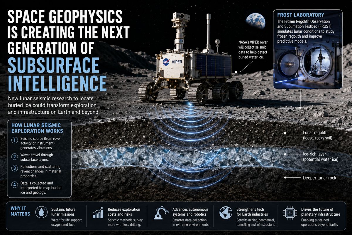
A benchtop cryogenic chamber the size of a dinner plate has just done something that matters far beyond the Artemis programme. Working with the Universities of Maryland and Hawaii, researchers at Lawrence Berkeley National Laboratory have shown that seismic waves can be used to prospect for buried water ice on the Moon, and they have built the rock-physics model needed to turn raw vibration data into a map of what lies underground.
The findings, published in Science Advances at the end of July 2026, arrive at a moment when subsurface characterisation is quietly becoming one of the most commercially contested capabilities in both the emerging lunar economy and the terrestrial energy transition. The same fundamental science that tells a geophysicist whether a moonquake has passed through ice rather than dry soil also underpins how carbon-storage operators verify a buried carbon dioxide plume and how geothermal developers characterise a reservoir before committing to a well.
That convergence is the real story. For the infrastructure and industrial-technology sectors, the significance is not that scientists have found a clever way to look for ice on another world. It is that the instruments, validated models and ground-truth datasets that make subsurface prospecting reliable are now the pinch-point technology for two parallel build-outs, one off-world and one very much on Earth.
Where a decade ago the value in geophysics sat largely in survey volume and acquisition hardware, it is increasingly concentrating in the ability to interpret what a survey actually means before a drill ever turns. Berkeley Lab’s work is a clear marker of that shift, and it deserves the attention of anyone whose capital is exposed to the cost and risk of drilling blind.
Briefing
- Berkeley Lab, the University of Maryland and the University of Hawaii have demonstrated that seismic surveying can locate buried water ice on the Moon, with findings published in Science Advances on 31 July 2026 and modelling that resolves subsurface structure to roughly 800 metres.
- The breakthrough rests on a new instrument, the Frozen Regolith Observation and Sublimation Testbed (FROST), a compact cryogenic vacuum chamber built at the Advanced Light Source and funded through Berkeley Lab in 2023 to generate the first reliable rock-physics data for lunar conditions.
- Seismic waves travel two to three times faster through ice-bearing regolith than through dry soil, giving different ice deposits distinctive and testable seismic signatures.
- The model faces near-term validation, with China’s Chang’e-7 lander and its onboard seismograph targeting a late-August 2026 launch window and a landing near Shackleton Crater, ahead of NASA’s revived VIPER rover, now contracted to Blue Origin for delivery in 2027.
- The same rock-physics principles feed directly into terrestrial subsurface markets, including carbon-storage verification, geothermal reservoir characterisation and cryosphere monitoring, with one market assessment valuing carbon-storage monitoring at 1.2 billion US dollars in 2024 and forecasting 4.8 billion by 2033.
The Ground-Truth Problem Holding Back Subsurface Prospecting
Every subsurface survey depends on a translation layer that turns physical measurements into geological meaning, and for lunar conditions that layer simply did not exist in usable form. Rock behaves in counter-intuitive ways in the deep cold and hard vacuum of the lunar surface, where there is no atmosphere to mediate how grains lock together and how ice binds the spaces between them.
Without laboratory measurements taken under those conditions, any attempt to interpret a seismic reading from the Moon would rest on assumptions imported from Earth, and those assumptions break down precisely where the ice is. As Harrison Lisabeth, the study’s lead author and a rock physicist in Berkeley Lab’s Energy Geosciences Division, put it, “When NASA scientists want to perform geological surveys on the moon, they will need rock physics models to understand the fundamentals of how the subsurface behaves,” adding that “we didn’t have very good models until now because materials behave weirdly in the high vacuum and super cold environment of the moon.”
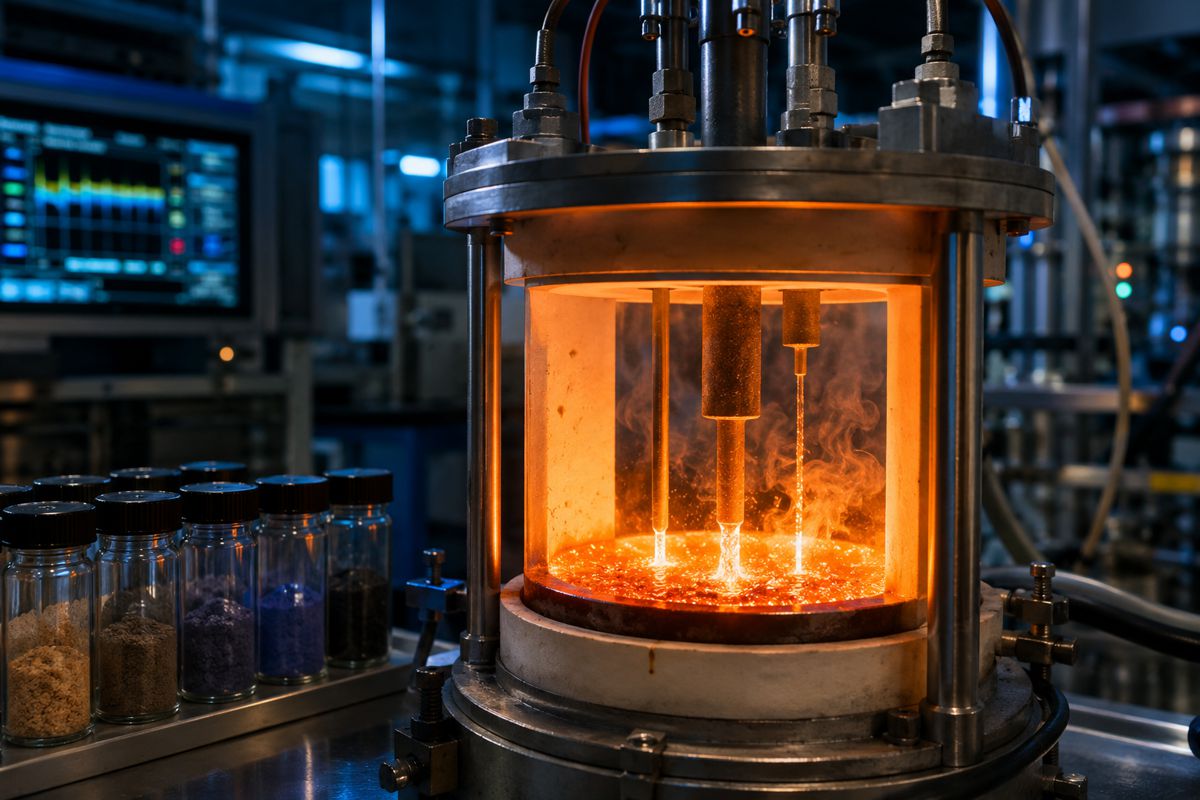
Closing that gap required building hardware that did not previously exist. FROST is a cryogenic vacuum chamber roughly 38 centimetres across, small enough to sit on a workbench, that bolts directly onto a beamline at the Advanced Light Source so that synchrotron X-rays can image samples in three dimensions while they sit in simulated lunar conditions. For its first study the team examined engineered regolith, Earth rock altered at NASA’s Johnson Space Center to mimic real lunar soil, watching how it deformed at the microscopic scale depending on how much ice was trapped inside.
The commercial logic here is straightforward and applies well beyond space science. A prospecting method is only as good as the physics that interprets its data, and organisations that own validated ground-truth measurements hold the asset that everyone downstream depends on. Berkeley Lab, funded through its Laboratory Directed Research and Development programme in 2023, effectively created that asset before the missions needing it had even launched.
From Moonquakes to Maps
The advance that will interest geophysicists is not any single measurement but the way three separate strands were combined into a working prediction. Lisabeth’s FROST experiments supplied the molecular-scale rock physics, co-author Matthew Siegler used satellite observations to model where large ice deposits are likely to sit and what keeps them stable over geological time, and Nicholas Schmerr contributed a seismic simulation capable of modelling how waves ripple through and interact with buried ice.
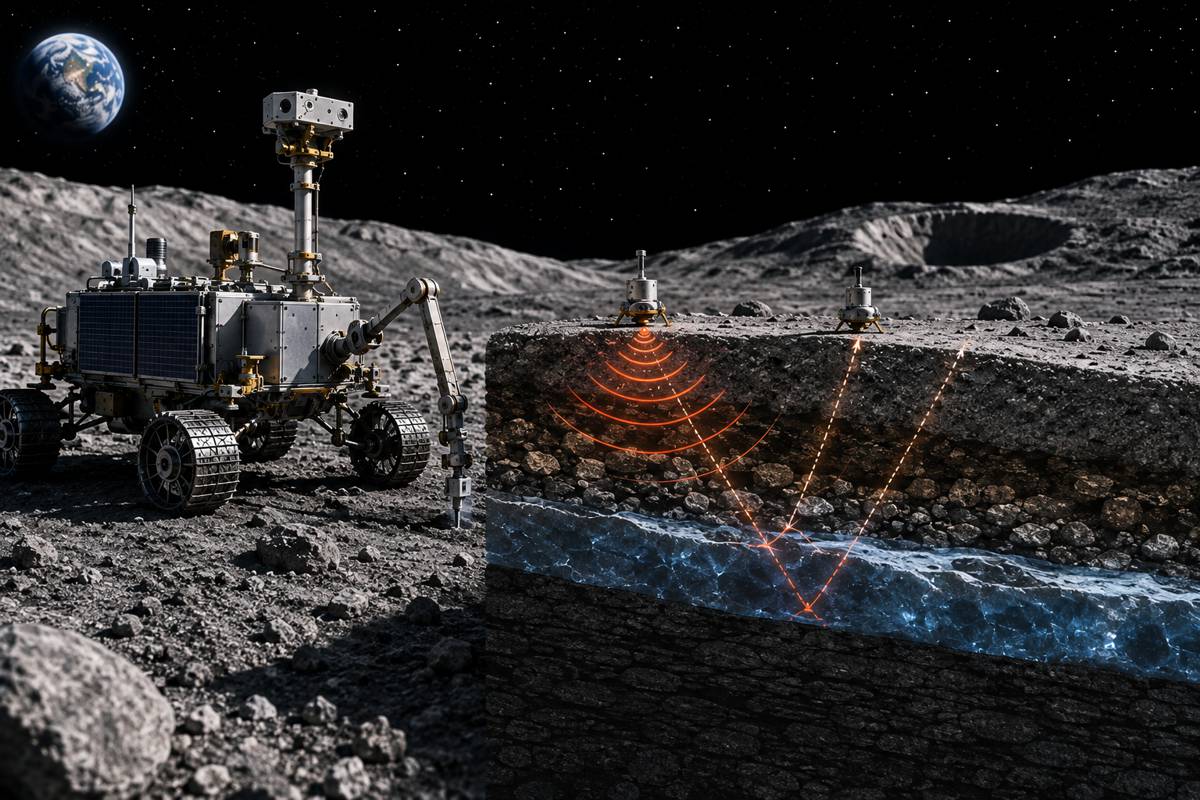
Assembled together, these allow researchers to predict how ice will alter a seismic wave and, critically, to design experiments that go looking for those effects. The headline result is that seismic waves travel two to three times faster through ice-bearing regolith than through dry soil, a difference large enough that each type of ice deposit leaves a clear and measurable mark in the data down to around 800 metres below the surface.
That distinction between detection and prediction is what turns a laboratory finding into an operational tool. The team has not merely confirmed that ice is detectable, it has produced specific, falsifiable expectations about what a genuine deposit should look like in a seismic record, which is exactly what a survey campaign needs in order to be worth its cost.
“Our model provides testable hypotheses to design seismic experiments looking for water on the Moon,” Schmerr said, framing the work as a design brief for future missions rather than a closed conclusion.
For any operator weighing the expense of drilling in a hostile environment, the value proposition is the same one that drives terrestrial exploration economics. A method that tells you where the resource is concentrated before you commit to a borehole converts an open-ended gamble into a targeted decision, and it is that de-risking of the drill, more than the physics itself, that makes the approach commercially significant.
A Validation Race Measured in Weeks
Most lunar-science models wait years for real data to test them against, and this one will not. China’s Chang’e-7 mission, one of the most complex robotic lunar undertakings attempted to date, carries a seismograph among its scientific payloads and is preparing for a launch window that opens in the second half of August 2026, with a landing targeted near Shackleton Crater at the lunar south pole later in the year.
That site sits amid some of the strongest suspected ice deposits on the Moon, which makes it close to an ideal proving ground for checking whether the seismic signatures the Berkeley Lab team predicts actually appear in live measurements. A model that receives its first real-world test within weeks of publication is a rare thing, and the outcome will shape how much confidence industry places in seismic prospecting as a resource-mapping method.
Behind Chang’e-7 sits a broader competitive field that has direct commercial weight. NASA cancelled the VIPER rover in 2024 on cost and schedule grounds, then reversed course in September 2025, awarding Blue Origin a Commercial Lunar Payload Services task order to deliver the already-assembled rover to the south pole in 2027 aboard a Blue Moon lander, subject to the company reaching flight readiness.
VIPER carries a percussive drill and navigational sensors that can double as seismic instruments, and Schmerr is a co-investigator on the mission, with the Berkeley Lab team explicitly intending to apply its model to VIPER data. Siegler set out why that matters, noting that “this lander has a percussive drill that makes seismic waves as it digs samples, and onboard sensors to measure how short frequency waves propagate underneath it. VIPER’s other tools can detect ice in the upper meter of the lunar soil, but these seismic waves might let us detect ice much deeper.
These experiments will give us a first glimpse of near-surface properties on the moon.” With a crewed return to the south polar region planned later this decade, and with Schmerr having helped develop a Lunar Environmental Monitoring Station intended for Artemis seismic work, subsurface prospecting is moving from a scientific curiosity toward a procurement line item in mission architecture.
The Water That Anchors an Off-World Economy
The reason this instrumentation attracts serious money is that lunar water is not a scientific trophy, it is the feedstock for everything a sustained presence needs. Water can supply drinking supplies and breathable oxygen, and when split into hydrogen and oxygen it becomes rocket propellant that need not be hauled up from Earth’s gravity well at enormous cost.
The entire business case for in-situ resource utilisation, the principle that a lunar base should live off locally available materials, turns on knowing where the most concentrated, most accessible ice actually sits rather than where orbital sensors merely hint that it might be. Orbiting spacecraft have detected promising surface signatures for years, but they cannot say how much ice lies deeper or how it is distributed, which is the precise question a validated seismic method is built to answer.
For investors and mission planners, that closes a loop that has long been left open. Propellant produced on the Moon changes the economics of every mission beyond it, including crewed travel toward Mars, but only if the resource can be located and quantified before infrastructure is committed. A prospecting toolkit that reduces the chance of drilling into barren regolith directly lowers the risk premium attached to the whole architecture.
The competition to demonstrate that capability, spanning China’s national programme, Blue Origin’s commercial delivery role and NASA’s science teams, is therefore also a competition over who sets the standards and owns the datasets that a future lunar resource market will price against. Value in that market is likely to accrue less to whoever moves the most regolith and more to whoever can prove, in advance, what is worth moving.
The Terrestrial Payoff Hiding in Plain Sight
For readers whose capital sits in earthbound infrastructure rather than spacecraft, the most consequential detail is that none of this science is exotic to terrestrial geophysics. The physics that makes seismic waves speed up through ice-filled pores is the same physics that lets operators image a carbon dioxide plume or characterise a geothermal reservoir, because in each case a fluid or solid filling the pore space changes the rock’s elastic properties and therefore how waves move through it.
Lisabeth’s routine work at Berkeley Lab uses the Advanced Light Source to characterise rocks under conditions mimicking the Earth’s subsurface, precisely to inform geothermal energy and carbon storage systems, and FROST has already been turned to studies of water transport and the dynamics of glaciers on Earth. The lunar application is, in effect, the extreme test case for a capability with a large and growing home market.
That home market is substantial and increasingly mandated by regulation. Time-lapse and passive seismic monitoring have become central to the measurement, monitoring and verification plans that carbon-storage operators must maintain to satisfy regulators, tracking how an injected plume grows and guarding against induced seismicity and leakage. One market assessment valued carbon-storage monitoring at 1.2 billion US dollars in 2024 and projected 4.8 billion by 2033, a compound annual growth rate approaching 17 per cent, with seismic sensing named as a core segment alongside satellite and ground-based methods.
Geothermal developers face a parallel need to characterise reservoirs and monitor pressure changes, and cryosphere and permafrost monitoring is drawing similar techniques as the built environment in cold regions responds to a warming climate. National-laboratory instruments and validated ground-truth datasets feed straight into this commercial pipeline, which is where the near-term revenue in subsurface sensing genuinely sits.
Where Value Concentrates in a Subsurface-First Market
Reading across the lunar and terrestrial threads, a consistent commercial pattern emerges, and it is worth stating plainly for industry leaders weighing where to place resources. The centre of gravity in subsurface work is moving away from raw acquisition and toward interpretation, calibration and the proprietary physics that make a survey trustworthy. Anyone can lay out geophones or fly a radar payload, but the party that owns the validated model linking a measured signal to a defensible geological conclusion holds the position that everyone else must license or replicate.
Lisabeth captured the underlying discipline when he said the aim is “to make measurements and help learn the fundamental geophysics for the moon and other bodies, so we can make sure we have the best models,” because, as he put it, “if you don’t have ground truth, you’re never going to understand what’s happening a hundred meters down or three kilometers down.”
The strategic implication for construction, energy and infrastructure firms is that ground-truth capability is becoming a competitive moat rather than a research nicety. Carbon-storage developers, geothermal operators and even large civil projects assessing deep foundations or tunnelling risk all depend on the same interpretive layer, and the organisations advancing it fastest are national laboratories and specialist geophysics suppliers rather than the asset owners themselves.
That creates an obvious opening for partnership, licensing and acquisition as the value of trustworthy subsurface interpretation is repriced upward. Firms that treat seismic and cryogenic characterisation as a commodity input risk being left dependent on a small number of holders of the models that actually matter, while those that invest early in the capability, or secure privileged access to it, position themselves to reduce drilling risk across a widening set of projects.
Reading the Next Survey Line
The immediate thing to watch is data. Within weeks, Chang’e-7’s seismograph should begin returning the first measurements capable of confirming or challenging the Berkeley Lab predictions, and a favourable result would mark seismic prospecting as a credible resource-mapping method rather than a promising hypothesis. That validation, followed in time by VIPER and by Artemis-deployed seismic instruments, would give both space agencies and terrestrial operators a shared, tested foundation for interpreting subsurface signals, and shared foundations tend to accelerate standardisation, tooling and investment.
The lunar and terrestrial applications will continue to cross-pollinate, with instruments such as FROST proving on ice-bound rock the same principles that carbon-storage and geothermal projects rely on underground.
For an industry accustomed to thinking of geophysics as a mature discipline, the more useful framing is that subsurface prospecting is entering a phase where confidence, not coverage, is the scarce commodity. The projects that will define the coming decade, whether they involve storing carbon at scale, unlocking geothermal heat, building in thawing ground or eventually extracting water on the Moon, all hinge on knowing what lies beneath before committing capital to it.
Berkeley Lab’s small chamber and the model it made possible are a reminder that the decisive advances in that field are as likely to come from a synchrotron beamline as from the field itself, and that the organisations paying attention to ground truth today are the ones best placed to price risk tomorrow.
Key Industry Questions
- Why does seismic prospecting matter more than existing methods for finding subsurface resources? Orbital sensors and surface instruments can flag where a resource such as ice or a stored fluid is likely to be, but they cannot reliably say how much lies at depth or how it is distributed. Seismic surveying reaches far deeper, in this case to around 800 metres on the Moon, and reveals the internal structure of the ground rather than just its surface. Because ice, carbon dioxide or water each change how quickly seismic waves travel, a calibrated model can distinguish a genuine deposit from empty rock. For operators, this converts an expensive open-ended search into a targeted decision, reducing the number of costly boreholes drilled into barren ground and lowering the overall risk attached to a project.
- How reliable is a model that has not yet been tested with real field data? The Berkeley Lab model is built on laboratory measurements taken under simulated lunar conditions, satellite-derived ice modelling and validated seismic simulation, which gives it a stronger physical basis than assumption-led approaches. Its authors are explicit that field validation is still required, and they have framed the work as a set of testable hypotheses rather than settled fact. That framing is a strength, because the predictions are specific enough to be confirmed or disproved. China’s Chang’e-7 seismograph and, later, NASA’s VIPER rover are expected to supply the first real-world checks, meaning the model will be validated against live data far sooner than most comparable scientific work ever is.
- What is the commercial relevance of lunar ice to terrestrial infrastructure firms? The direct relevance is limited, but the indirect relevance is considerable. The rock physics used to detect lunar ice is the same physics that governs how carbon dioxide plumes and geothermal reservoirs are imaged on Earth, because a fluid or solid filling pore space alters how seismic waves move. Instruments and datasets developed for the Moon therefore feed into terrestrial subsurface markets that are already large and growing. Firms involved in carbon storage, geothermal energy, deep foundations or tunnelling all rely on the same interpretive capability, so advances driven by lunar exploration can lower the cost and raise the reliability of characterising the ground beneath earthbound projects.
- How large is the terrestrial market for subsurface seismic monitoring? Carbon-storage monitoring alone was valued at 1.2 billion US dollars in 2024 in one market assessment, with a forecast of 4.8 billion by 2033 and a compound annual growth rate approaching 17 per cent, and seismic sensing is identified as a core technology segment within it. That figure sits alongside separate demand from geothermal development, induced-seismicity risk management and cryosphere monitoring. Growth is being driven partly by regulation, since measurement, monitoring and verification plans that rely on seismic methods are increasingly mandatory for carbon-storage projects. The combined effect is a widening, regulation-backed market for the sensors, models and interpretation services that make subsurface characterisation dependable.
- Why is the timing of the Chang’e-7 mission significant for this research? Chang’e-7 carries a seismograph and is preparing for a launch window opening in the second half of August 2026, with a landing planned near Shackleton Crater in a region rich in suspected ice deposits. That places a direct test of the Berkeley Lab predictions only weeks after their publication, an unusually rapid path from theory to validation. If the seismic signatures the model forecasts appear in Chang’e-7’s data, seismic prospecting gains immediate credibility as a resource-mapping method. The mission also underlines how internationally competitive lunar resource exploration has become, with China moving ahead of the revived VIPER timeline in demonstrating south polar seismic capability.
- What happened to NASA’s VIPER rover and why does it still matter? NASA cancelled VIPER in 2024, citing cost growth and schedule delays, at a point when the rover was already largely assembled. In September 2025 the agency reversed that decision, awarding Blue Origin a task order to deliver VIPER to the south pole in 2027 aboard a Blue Moon lander, subject to the company reaching flight readiness. VIPER matters here because its percussive drill and onboard sensors can generate and record seismic waves, allowing it to probe for ice well below the upper metre that its other instruments reach. The Berkeley Lab team, which includes a VIPER co-investigator, intends to apply its model to that data.
- What should infrastructure and energy companies do in response to these developments? The practical takeaway is to treat validated subsurface interpretation as a strategic capability rather than a commodity input. As carbon storage, geothermal energy and cold-region construction scale up, the ability to characterise the ground reliably before drilling becomes a source of competitive advantage and risk reduction. Companies dependent on subsurface work should assess whether they have privileged access to trustworthy models and ground-truth datasets, or whether they are exposed to a small number of specialist holders. Options include partnering with national laboratories and geophysics specialists, licensing validated models, or acquiring the capability outright as its commercial value is repriced upward.
- Could this approach reduce the cost of major infrastructure projects on Earth? It can, principally by cutting the risk and expense of drilling and injection. Any project that depends on understanding what lies underground, from carbon-storage injection wells to geothermal boreholes and deep foundations, carries significant cost exposure if the ground turns out to differ from expectations. Better seismic interpretation, grounded in laboratory-validated rock physics, narrows that uncertainty and reduces the number of exploratory operations needed to reach a confident decision. The savings are indirect but real, arising from fewer failed boreholes, better-targeted injection and monitoring, and lower regulatory and remediation risk over a project’s lifecycle.
Strategic Takeaways
- Value in subsurface geophysics is shifting from acquisition volume toward validated interpretation, and the organisations that own trustworthy rock-physics models and ground-truth datasets increasingly hold the position that asset owners must license or replicate.
- The rock physics developed to prospect for lunar ice is directly transferable to carbon-storage verification and geothermal reservoir characterisation, linking a space-science advance to terrestrial infrastructure markets already worth billions and growing at a double-digit annual rate.
- Regulation is becoming a demand driver in its own right, with seismic-based measurement, monitoring and verification increasingly mandatory for carbon storage, which should sustain investment in subsurface sensing regardless of wider market cycles.
- The credibility of seismic resource prospecting will be tested within weeks by Chang’e-7 and later by VIPER, and a favourable result would accelerate standardisation and tooling across both lunar and terrestrial subsurface applications.
- Infrastructure and energy firms exposed to drilling risk should review whether they have secure access to validated subsurface interpretation, since partnership, licensing or acquisition of that capability is likely to become a competitive differentiator as its value is repriced upward.