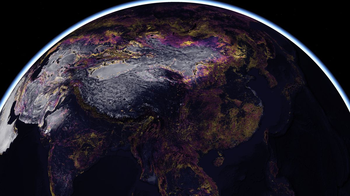
Esri releases new predictive Global Land Cover Map for 2050
Esri, the global leader in location intelligence, today announced it is releasing a new high-resolution, 2050 global land cover map as part of the company’s Living Atlas. Built in partnership with Clark Labs and using European Space Agency (ESA) 2010 and 2018 climate change initiative (CCI) satellite imagery, the map lets users see how the world’s land cover will change 30 years into the future.
This new series of analytical layers available in ArcGIS Living Atlas of the World leverages decades of historic observations along with patterns of land use and development to let users predict land cover in 2050. Each 300-meter pixel of the Earth is classified by land cover type and the vulnerability of human activity to modify it. The map includes three crucial layers that detail change in land cover up to the present, risk to that land, and the projected future change.
“The ability to understand the challenges posed by climate change to the planet alone is critical to our survival,” said Jack Dangermond, Esri founder and president. “But the power to virtually see into the future and visualize these material issues as they might unfold tomorrow is transformative. This new map demonstrates one way GIS can help us use technology to build a more sustainable world.”
In June, Esri released the first high-resolution global land cover map, supporting change detection and highlighting planetary land changes, especially related to the effects of human activity. Similar to that release, planners worldwide can use the 2050 Global Land Cover Map to better understand the geography around them with distinctive land cover, as well as human activity affecting them. Specifically, decision-makers can project future land cover patterns, allowing them to better assess the impact risks imposed by development or industry in a given location.
“Advancements in our understanding of land change processes and the power of geospatial neural networks has afforded us unprecedented opportunities to anticipate environmental changes ahead,” said J. Ronald Eastman, Professor of Geography and Director of Clark Labs at Clark University. “This provides us with the opportunity, and obligation, to be proactive in our stewardship of natural resources.”
Esri is releasing this mapping resource under a Creative Commons license to encourage broad adoption and ensure equitable access for planners creating a more sustainable planet. The content will be made available in ArcGIS Online as a map service and be freely available for use by its 10 million users. It will also be available for download and viewing. To explore the new 2050 Global Land Cover Map, visit livingatlas.arcgis.com/landcover-2050.