






Mapbox Brings Cycling Navigation into Meta Ray-Ban Smart Glasses
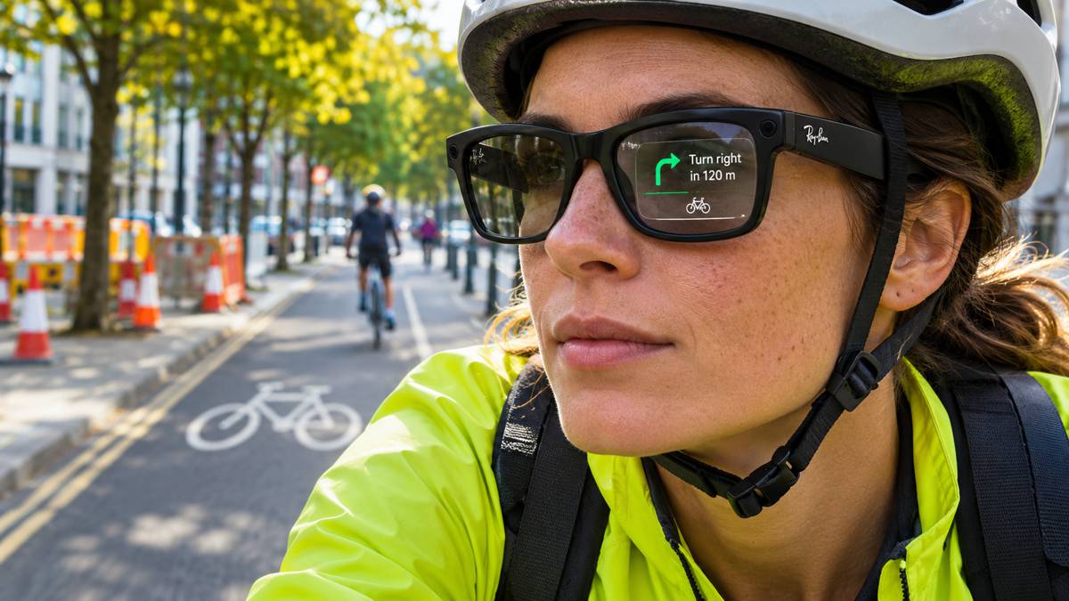
Cyclists using Meta Ray-Ban Display glasses can receive turn-by-turn directions directly within their field of view, following an expanded partnership between mapping technology specialist Mapbox and Meta. The system combines bicycle-specific route planning with visual instructions and open-ear audio, allowing riders to navigate unfamiliar streets without repeatedly consulting a smartphone or handlebar-mounted display.
Announced by Mapbox, the integration brings the company’s routing and location technology into Meta’s wearable platform. It follows the introduction of cycling navigation by Meta in September and extends an existing relationship between the two companies.
Briefing
- Mapbox is providing cycling navigation technology for Meta Ray-Ban Display smart glasses.
- Turn-by-turn directions appear within the glasses, supported by spoken instructions through open-ear audio.
- Routes are optimised for cycling and automatically recalculated when riders change direction.
- Meta announced cycling navigation in September 2026, initially for users in the United States and Canada.
- The partnership expands Mapbox’s work in wearable navigation alongside its established automotive and location services business.
Cycling Navigation Without Looking at a Phone
For cyclists travelling through unfamiliar urban areas, following a digital route can mean balancing navigation against awareness of surrounding traffic. Smartphone applications provide detailed mapping, but checking a screen mounted on the handlebars or carried in a pocket can interrupt a rider’s attention, particularly when approaching complicated junctions or negotiating busy roads.
The Meta Ray-Ban Display integration places directional information within the glasses themselves, accompanied by spoken instructions through the open-ear audio system. Riders can follow a route while keeping their hands on the handlebars, and if they take a different street or path, the navigation system recalculates directions to accommodate the change.
Mapbox provides routing designed specifically for cycling rather than simply transferring automotive directions onto a smaller display. Its wider cycling navigation technology can favour streets with cycle lanes and avoid highways, reflecting the different access requirements and operating conditions of bicycle travel. In urban areas, where networks frequently combine segregated infrastructure, shared roads and routes through public spaces, the suitability of a journey depends on considerably more than the shortest distance between two points.
The wearable interface introduces its own considerations. Directions must be sufficiently clear to interpret at a glance, while route instructions need to arrive early enough for riders to respond safely. Although presenting information within the field of view may reduce the need to look down at a separate screen, cyclists must still assess traffic conditions and surrounding hazards rather than relying entirely on digital guidance.
Mapbox Provides the Routing Technology
The partnership builds on Mapbox’s wider business in digital mapping, route calculation and location services. Its technology supports automotive navigation, logistics platforms and consumer applications, with developers accessing mapping capabilities through software development kits and application programming interfaces.
According to Mapbox, its location infrastructure incorporates continuously updated information and anonymised movement signals from more than 45,000 applications. The company describes its underlying technology as an agentic mapping engine, designed to help software systems interpret locations, movement and changes within the physical environment. The figure relates to Mapbox’s wider mapping operations rather than exclusively to the navigation service used in Meta’s glasses.
For wearable navigation, route calculation is only part of the technical challenge. The system must establish the user’s position, identify appropriate streets and paths, associate instructions with individual junctions and update guidance as the journey progresses. Those functions must also be presented through a compact display, where the amount of information that can be shown without overwhelming the wearer is considerably more limited than on a smartphone.
Peter Sirota, CEO of Mapbox, explained the company’s approach: “As AI moves beyond the screen and into the physical world, understanding location becomes essential,” said Sirota. “Our work with Meta brings Mapbox’s maps, routing, and navigation technology into a new kind of everyday experience, helping people get where they want to go with useful guidance right in their field of view.”
Mapbox supplies the underlying maps, routing and navigation capabilities while Meta develops the wearable experience through which users receive instructions. The arrangement allows established geospatial systems to be adapted to new devices without requiring their manufacturers to develop the entire mapping infrastructure independently.
An Expanding Market for Wearable Mapping
Meta announced cycling and public transport directions for Ray-Ban Display glasses at its September 2026 Connect event, with the navigation features initially scheduled for availability in the United States and Canada. The company has also expanded sales of the glasses into the UK, France, Italy and Germany, although availability of the hardware does not necessarily mean every navigation feature is supported in those markets.
Mapbox has been working with other manufacturers exploring alternatives to conventional navigation displays. In July 2026, the company described its collaboration with Snap on augmented reality navigation for its Specs wearable platform. That project involved adapting Mapbox’s navigation software development kit to operate on compact hardware, with engineers optimising the software and map data for the device’s computing environment.
The automotive sector offers a related application of location technology. In October, Mapbox announced 3D Live Navigation for BMW’s Neue Klasse vehicles, incorporating lane-level guidance and information from driver assistance systems into a three-dimensional mapping interface. The presentation is different from that used in smart glasses, but both applications involve translating detailed geospatial information into guidance that can be understood while travelling.
Wearable devices impose particularly demanding constraints on navigation software. Displays are smaller, power consumption must be controlled and instructions cannot occupy the user’s attention for extended periods. The timing and presentation of information therefore become as important to the user experience as the underlying route calculation.
Mapping Accuracy and Road Safety
Cycling navigation presents challenges that cannot be resolved through display technology alone. Road layouts change, access restrictions are introduced and routes that are technically available may be uncomfortable or unsuitable for less experienced cyclists. The quality of the underlying mapping information remains central to the usefulness of any navigation system, whether instructions appear on a smartphone, a vehicle dashboard or within a pair of glasses.
Construction activity makes this particularly apparent. Roadworks can close cycle lanes, divert riders into general traffic or temporarily alter access arrangements at junctions. In some locations, temporary traffic management may require cyclists to dismount or follow a diversion that is unfamiliar even to regular users of the route. Unless those changes are accurately represented within digital mapping systems, navigation software may continue recommending a route that is no longer available.
The problem extends beyond individual roadworks. Permanent changes to junction layouts, newly installed cycle infrastructure and revised traffic restrictions must also find their way into mapping databases. Transport authorities and mapping providers consequently depend on reliable processes for identifying and communicating changes across the road network, although the availability and timeliness of such information vary between locations.
There are separate questions about the safety of presenting visual information within a rider’s field of view. Instructions must be readable without obscuring potential hazards or encouraging prolonged attention to the display. The UK’s Highway Code addresses distraction associated with navigation and screen-based information, providing a useful general principle even though it does not specifically assess smart-glasses interfaces for cycling.
Neither Mapbox nor Meta has provided comparative evidence in the announcement demonstrating reduced cycling accidents or distraction through the new system. The ability to receive directions without consulting a separate screen is an identifiable practical benefit, but its effect on road safety would require independent assessment under representative riding conditions.
Location Technology Beyond the Dashboard
Wearable navigation introduces another application for the location infrastructure already used in vehicles, logistics operations and journey-planning services. The underlying software must accommodate devices with different displays, processing capabilities and user interfaces while continuing to provide accurate route information.
Similar approaches could eventually support location-aware guidance for infrastructure inspectors, maintenance personnel and workers operating across large industrial sites. Such uses would require appropriate mapping, operational information and safety controls, particularly where conventional road navigation data would not describe the working environment adequately.
For Mapbox, the Meta partnership extends its routing technology into a consumer device where navigation is delivered through a substantially different interface. Cyclists receive the directions through the glasses, but the underlying journey still depends on the familiar requirements of accurate positioning, appropriate route selection and timely updates when conditions change.
The everyday test will come at junctions, along unfamiliar cycle routes and wherever the road network differs from the information held in the map. A direction delivered at eye level is only useful if it arrives at the right moment and leads the rider along a suitable route.
Key Industry Questions
- What is Mapbox providing for Meta Ray-Ban Display glasses? Mapbox supplies location and routing technology supporting turn-by-turn cycling directions, with visual instructions presented within the glasses and accompanying spoken guidance.
- Can cyclists receive directions without looking at a smartphone? Yes. Directions appear within the Meta Ray-Ban Display glasses, allowing riders to follow a route without repeatedly consulting a separate phone screen.
- How does the system respond when cyclists leave their planned route? The navigation system automatically recalculates directions when a rider takes a different street or path, allowing the journey to continue along a revised route.
- How does cycling navigation differ from car navigation? Cycling routes can account for dedicated cycle infrastructure, access restrictions and roads suitable for bicycles. Routing preferences differ from those used for motor vehicles.
- Where is Meta Ray-Ban Display cycling navigation available? Meta initially announced the feature for the United States and Canada in September 2026. The glasses are sold in additional markets, but feature availability may differ by country.
- Do all Ray-Ban Meta glasses support visual cycling directions? No. The announced in-lens navigation functionality applies specifically to Meta Ray-Ban Display glasses, which incorporate a visual display.
- Could smart-glasses navigation improve cycling safety? Visual and audio directions may reduce the need to consult a separate screen, but independently verified evidence demonstrating reduced distraction or accident rates has not been provided.
- How do roadworks affect digital cycling navigation? Temporary closures, diverted cycle lanes and altered junction layouts can make planned routes unavailable. Accurate and timely mapping updates are needed to reflect these changes.
- Could wearable navigation technology be used in construction? Location-aware displays could potentially support inspections, maintenance activities and navigation around industrial sites. Such applications would require specialised mapping, operational integration and suitable safety assessments.
Strategic Takeaways
- Wearable navigation creates opportunities for mapping technology providers to supply location services across a wider range of consumer devices.
- Cycling-specific routing must account for infrastructure, access restrictions and the practical suitability of individual streets and paths.
- Temporary traffic management and permanent road changes remain challenges for maintaining accurate digital navigation data.
- Compact wearable displays require navigation instructions to be delivered with particular attention to timing, clarity and distraction.
- Mapbox’s work with Meta, Snap and automotive manufacturers demonstrates how established geospatial technology can be adapted to different hardware platforms.